
The Fraser River is the longest river within British Columbia, Canada, rising at Fraser Pass near Blackrock Mountain in the Rocky Mountains and flowing for 1,375 kilometres (854 mi), into the Strait of Georgia just south of the City of Vancouver. The river's annual discharge at its mouth is 112 cubic kilometres (27 cu mi) or 3,550 cubic metres per second (125,000 cu ft/s), and each year it discharges about 20 million tons of sediment into the ocean.

The North Cascades are a section of the Cascade Range of western North America. They span the border between the Canadian province of British Columbia and the U.S. state of Washington and are officially named in the U.S. and Canada as the Cascade Mountains. The portion in Canada is known to Americans as the Canadian Cascades, a designation that also includes the mountains above the east bank of the Fraser Canyon as far north as the town of Lytton, at the confluence of the Thompson and Fraser Rivers.
The Stʼatʼimc, also known as the Lillooet, St̓át̓imc, or Stl'atl'imx, are an Interior Salish people located in the southern Whale Mountains and Fraser Canyon region of the Interior of the Canadian province of British Columbia.

The Thompson River is the largest tributary of the Fraser River, flowing through the south-central portion of British Columbia, Canada. The Thompson River has two main branches, the South Thompson River and the North Thompson River. The river is home to several varieties of Pacific salmon and trout. The area's geological history was heavily influenced by glaciation, and the several large glacial lakes have filled the river valley over the last 12,000 years. Archaeological evidence shows human habitation in the watershed dating back at least 8,300 years. The Thompson was named by Fraser River explorer, Simon Fraser, in honour of his friend, Columbia Basin explorer David Thompson. Recreational use of the river includes whitewater rafting and angling.

The Stein Valley Nlaka’pamux Heritage Park is located near Lytton, British Columbia. The park was established in 1995. The park is co-managed, operated, and planned through a partnership between the Lytton First Nation and the government of British Columbia. The park provides recreational opportunities and cultural heritage activities, and features a number of pictographs.
Indigenous peoples of the Northwest Plateau, also referred to by the phrase Indigenous peoples of the Plateau, and historically called the Plateau Indians are Indigenous peoples of the Interior of British Columbia, Canada, and the non-coastal regions of the Northwestern United States.

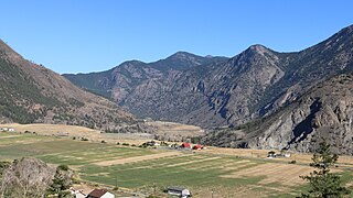
The Fraser Canyon is a major landform of the Fraser River where it descends rapidly through narrow rock gorges in the Coast Mountains en route from the Interior Plateau of British Columbia to the Fraser Valley. Colloquially, the term "Fraser Canyon" is often used to include the Thompson Canyon from Lytton to Ashcroft, since they form the same highway route which most people are familiar with, although it is actually reckoned to begin above Williams Lake at Soda Creek Canyon near the town of the same name.

The Lillooet Ranges are the southeasternmost subdivision of the Pacific Ranges of the Coast Mountains of British Columbia. They are located between the drainage of the Lillooet River and Harrison Lake on the west and the canyon of the Fraser River on the east, and by the lowland coastal valley of that river on the south.

The Clear Range is a small mountain range located in the angle of the Fraser and Thompson Rivers in south-central British Columbia, Canada. It has a small subdivision just northeast of that confluence named the Scarped Range. The Clear Range totals 16,270 km2 (6,280 sq mi) and is 75 km (47 mi) north to south and 35 km (22 mi) east to west. The Clear Range and its northward neighbour the Marble Range are both subranges of the Pavilion Range.

The Camelsfoot Range is a sub-range of the Chilcotin Ranges subdivision of the Pacific Ranges of the Coast Mountains in British Columbia. The Fraser River forms its eastern boundary. The range is approximately 90 km at its maximum length and less than 30 km wide at its widest.

The Secwépemc, also known by the exonym Shuswap, are a First Nations people residing in the interior of the Canadian province of British Columbia. They speak one of the Salishan languages, known as Secwepemctsín or Shuswap.
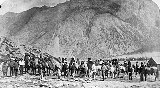
The Fraser Canyon War, also known as the Canyon War or the Fraser River War, was an incident between white miners and the indigenous Nlaka'pamux people in the newly declared Colony of British Columbia, which later became part of Canada, in 1858. It occurred during the Fraser Canyon Gold Rush, which brought many white settlers to the Fraser Canyon area. Largely ignored by Canadian historians, it was one of the seminal events of the founding of the colony. Although it ended relatively peacefully, it was a major test of the new administration's control over the goldfields, which were distant and difficult to access from the centre of colonial authority at Victoria in the Colony of Vancouver Island.
Nicola, also Nkwala or N'kwala, was an important First Nations political figure in the fur trade era of the British Columbia Interior as well as into the colonial period (1858–1871). He was grand chief of the Okanagan people and chief of the Nicola Valley peoples, an alliance of Nlaka'pamux and Okanagans and the surviving Nicola Athapaskans, and also of the Kamloops Band of the Shuswap people.
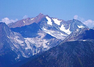
Skihist Mountain, also sometimes referred to as Skihist Peak, is the highest mountain in the Cantilever Range and in southwestern British Columbia, Canada. It is located on the southern boundary of Stein Valley Nlaka'pamux Heritage Park, about 20 km (12 mi) west of Lytton. It is the highest summit in the Lillooet Ranges, which lie between the Lillooet and Fraser Rivers, south of the Gates Valley and Seton and Anderson Lakes.
Fountain is an unincorporated rural area and Indian reserve community in the Fraser Canyon region of British Columbia, Canada, located at the ten-mile (16 km) mark from the town of Lillooet on BC Highway 99, which in that area is also on the route of the Old Cariboo Road and is located at the junction of that route with the old gold rush-era trail via Fountain Valley and the Fountain Lakes.

Thompson Country, also referred to as The Thompson and sometimes as the Thompson Valley and historically known as the Couteau Country or Couteau District, is a historic geographic region of the Southern Interior of British Columbia, more or less defined by the basin of the Thompson River. This is a tributary of the Fraser; the major city in the area is Kamloops.
Annie Zixtkwu York was a distinguished elder of the Nlaka'pamux people of the Spuzzum First Nation of Spuzzum, in Fraser Canyon located in the lower region of British Columbia, Canada. York was raised by her Nlaka'pamux family where she came to be bilingual speaking English and Nlaka'pamuctsin. She dedicated herself to the Christian religion and the beliefs of the Nlaka'pamux people, Nle'kepmx. York's family members educated her about the history of Spuzzum as well as the origin of its name, Spuzzum chiefs, and the ethnobotany of the region. York was known to be a storyteller, always recording and sharing stories.
The Nlakaʼpamux or Nlakapamuk, also previously known as the Thompson, Thompson River Salish, Thompson Salish, Thompson River Indians or Thompson River people, and historically as the Klackarpun, Haukamaugh, Knife Indians, and Couteau Indians, are an Indigenous First Nations people of the Interior Salish language group in southern British Columbia. Their traditional territory includes parts of the North Cascades region of Washington.
Botanie Valley is in British Columbia's southern interior near Lytton. It is a traditional food source for the Nlaka'pamux people. The name itself means "covering" possibly referring to the abundant plant life covering the area. Botanie Creek enters the Thompson River a few kilometres upstream of its confluence with the Fraser River, making Botanie the Thompson River's last tributary.
Texas Creek is a medium-sized right tributary of the Fraser River in the Fraser Canyon region of that river's course, located approximately 16 miles down the river from the town of Lillooet. Texas Creek is also the name of the rural neighbourhood in the area of the creek, and also that of the Texas Creek Ranch which is one of the larger holdings.


