Brentwood Colony, South Dakota | |
|---|---|
 Brentwood Colony  Brentwood Colony | |
| Coordinates: 45°09′05″N99°17′54″W / 45.15139°N 99.29833°W | |
| Country | United States |
| State | South Dakota |
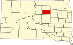
| County | Faulk |
| Area | |
• Total | 0.98 sq mi (2.54 km2) |
| • Land | 0.87 sq mi (2.26 km2) |
| • Water | 0.11 sq mi (0.28 km2) |
| Elevation | 1,716 ft (523 m) |
| Population | |
• Total | 116 |
| • Density | 133.2/sq mi (51.41/km2) |
| Time zone | UTC-6 (Central (CST)) |
| • Summer (DST) | UTC-5 (CDT) |
| ZIP Code | 57438 (Faulkton) |
| Area code | 605 |
| FIPS code | 46-07068 |
| GNIS feature ID | 2813024 [2] |
Brentwood Colony is a Hutterite colony [4] and census-designated place (CDP) in Faulk County, South Dakota, United States. The population was 116 at the 2020 census. [5] It was first listed as a CDP prior to the 2020 census. [2]
It is in the northwest part of the county, 17 miles (27 km) by road northwest of Faulkton, the county seat, and 8 miles (13 km) southwest of Norbeck. Thunderbird Colony is 5 miles (8 km) by road to the northeast.