Rockham, South Dakota

Last updated

Rockham, South Dakota
Faulk County South Dakota Incorporated and Unincorporated areas Rockham Highlighted.svg
Location in Faulk County and the state of South Dakota
Coordinates: 44°54′15″N98°49′24″W / 44.90417°N 98.82333°W / 44.90417; -98.82333
Country United States
State South Dakota
County Faulk
Platted 1886 [1]
Area
[2]
  Total0.50 sq mi (1.29 km2)
  Land0.50 sq mi (1.29 km2)
  Water0.00 sq mi (0.00 km2)
Elevation
[3]
1,401 ft (427 m)
Population
 (2020) [4]
  Total22
  Density44.18/sq mi (17.06/km2)
Time zone UTC-6 (Central (CST))
  Summer (DST) UTC-5 (CDT)
ZIP code
57470
Area code 605
FIPS code 46-55540 [5]
GNIS feature ID1267553 [3]

Rockham is a town in Faulk County, South Dakota, United States, off U.S. Route 212, and was a stop on the old Chicago and North Western Railway. The population was 22 at the 2020 census. [6]

Contents

History

Rockham was platted in 1886. [7] It was named after Rockhampton, in Australia. [7] A post office has been in operation in Rockham since 1887. [8]

The Chicago & North Western Railway constructed a rail line from Redfield to Faulkton in 1886. [9] Rockham was founded as a stop on the railway that year, in 1886 on land originally homesteaded by Anders Opperud, and was incorporated on March 4, 1909. Rockham's first school, the F.M. Brown School, was erected in 1884; the Rockham Public School was built in 1915. Rockham received its first telephone service in 1903 and electrical power was distributed throughout the city in 1919. [10]

In 1925, the Rockham Public School was damaged by a tornado. [11]

In 1970, the Chicago & North Western Railway abandoned its rail line from Redfield to Gettysburg, leaving Rockham without rail service for hauling grain. [12]

The Rockham Public School closed in 1972.

Rockham celebrated its centennial on July 4–6, 1986.

Geography

According to the United States Census Bureau, the town has a total area of 0.50 square miles (1.29 km2), all land. [13]

Demographics

Historical population
CensusPop.Note
1910 286
1920 34721.3%
1930 288−17.0%
1940 220−23.6%
1950 113−48.6%
1960 19774.3%
1970 60−69.5%
1980 52−13.3%
1990 48−7.7%
2000 5310.4%
2010 33−37.7%
2020 22−33.3%
U.S. Decennial Census [14] [4]

2010 census

As of the census [15] of 2010, there were 33 people, 13 households, and 6 families residing in the town. The population density was 66.0 inhabitants per square mile (25.5/km2). There were 28 housing units at an average density of 56.0 per square mile (21.6/km2). The racial makeup of the town was 100.0% White.

There were 13 households, of which 23.1% had children under the age of 18 living with them, 46.2% were married couples living together, and 53.8% were non-families. 38.5% of all households were made up of individuals, and 15.4% had someone living alone who was 65 years of age or older. The average household size was 2.54 and the average family size was 4.00.

The median age in the town was 34.5 years. 36.4% of residents were under the age of 18; 0.0% were between the ages of 18 and 24; 15.2% were from 25 to 44; 27.4% were from 45 to 64; and 21.2% were 65 years of age or older. The gender makeup of the town was 60.6% male and 39.4% female.

2000 census

As of the census [5] of 2000, there were 53 people, 18 households, and 14 families residing in the town. The population density was 107.2 inhabitants per square mile (41.4/km2). There were 27 housing units at an average density of 54.6 per square mile (21.1/km2). The racial makeup of the town was 98.11% White, and 1.89% from two or more races.

There were 18 households, out of which 38.9% had children under the age of 18 living with them, 77.8% were married couples living together, and 22.2% were non-families. 22.2% of all households were made up of individuals, and 5.6% had someone living alone who was 65 years of age or older. The average household size was 2.94 and the average family size was 3.43.

In the town, the population was spread out, with 30.2% under the age of 18, 1.9% from 18 to 24, 35.8% from 25 to 44, 15.1% from 45 to 64, and 17.0% who were 65 years of age or older. The median age was 36 years. For every 100 females, there were 112.0 males. For every 100 females age 18 and over, there were 105.6 males.

The median income for a household in the town was $35,625, and the median income for a family was $68,750. Males had a median income of $23,750 versus $16,667 for females. The per capita income for the town was $19,511. None of the population and none of the families were below the poverty line.

Related Research Articles

<span class="mw-page-title-main">Ludden, North Dakota</span> City in North Dakota, United States

Ludden is a city in Dickey County, North Dakota, United States. The population was 15 at the 2020 census. Ludden was founded in 1886.

<span class="mw-page-title-main">Oakes, North Dakota</span> City in North Dakota, United States

Oakes is the most populous city in Dickey County, North Dakota, United States. The population was 1,798 at the 2020 census. Oakes was founded in 1886.

<span class="mw-page-title-main">Broadland, South Dakota</span> Town in South Dakota, United States

Broadland is a town in Beadle County, South Dakota, United States. The population was 27 at the 2020 census.

<span class="mw-page-title-main">Hitchcock, South Dakota</span> Town in South Dakota, United States

Hitchcock is a town in Beadle County, South Dakota, United States. The population was 112 at the 2020 census.

<span class="mw-page-title-main">Groton, South Dakota</span> City in South Dakota, United States

Groton is a city in southeastern Brown County, South Dakota, United States. The population was 1,380 at the 2020 census.

<span class="mw-page-title-main">Hecla, South Dakota</span> City in South Dakota, United States

Hecla is a city in Brown County, South Dakota, United States, located only a few miles south of the North Dakota border. The population was 193 at the 2020 census. State Highway 37 runs along the east side of town.

<span class="mw-page-title-main">Raymond, South Dakota</span> Town in South Dakota, United States

Raymond is a town in western Clark County, South Dakota, United States. The population was 53 at the 2020 census.

<span class="mw-page-title-main">Wakonda, South Dakota</span> Town in South Dakota, United States

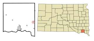
Wakonda is a town in Clay County, South Dakota, United States. The population was 347 at the 2020 census.

<span class="mw-page-title-main">Fairburn, South Dakota</span> Town in South Dakota, United States

Fairburn is a town in Custer County, South Dakota, United States. The population was 60 at the 2020 census.

<span class="mw-page-title-main">Hermosa, South Dakota</span> Town in South Dakota, United States

Hermosa is a town near the northern edge of Custer County, South Dakota, United States. The population was 382 at the 2020 census.

<span class="mw-page-title-main">Faulkton, South Dakota</span> City in South Dakota, United States

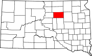
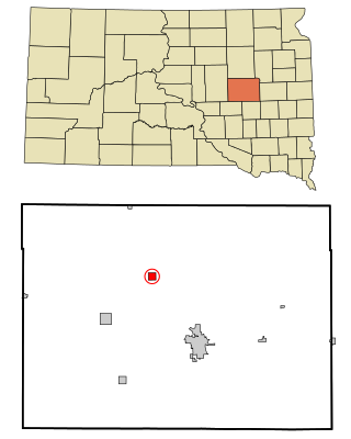
Faulkton is a city in and county seat of Faulk County, South Dakota, United States. The population was 826 at the 2020 census. The city's nickname is "The Carousel City".

<span class="mw-page-title-main">Seneca, South Dakota</span> Town in South Dakota, United States

Seneca is a town in Faulk County, South Dakota, United States. The population was 22 at the 2020 census.

<span class="mw-page-title-main">Farmer, South Dakota</span> Town in South Dakota, United States

Farmer is a town in Hanson County, South Dakota, United States. It is part of the Mitchell, South Dakota Micropolitan Statistical Area. The population was 15 at the 2020 census.

<span class="mw-page-title-main">Fulton, South Dakota</span> Town in South Dakota, United States

Fulton is a town in Hanson County, South Dakota, United States. It is part of the Mitchell, South Dakota Micropolitan Statistical Area. The population was 87 at the 2020 census.

<span class="mw-page-title-main">Whitewood, South Dakota</span> City in South Dakota, United States

Whitewood is a city in Lawrence County, South Dakota, United States. The population was 879 at the 2020 census.

<span class="mw-page-title-main">Vilas, South Dakota</span> Town in South Dakota, United States

Vilas is a town in Miner County, South Dakota, United States. The population was 29 at the 2020 census.

<span class="mw-page-title-main">Quinn, South Dakota</span> Town in South Dakota, United States

Quinn is a town in Pennington County, South Dakota, United States. The population was 63 at the 2020 census. The town is the home of the Badlands Observatory, located in the former community hospital, built in 1950.

<span class="mw-page-title-main">Conde, South Dakota</span> City in South Dakota, United States

Conde is a city in Spink County, South Dakota, United States. The population was 142 at the 2020 census.

<span class="mw-page-title-main">Redfield, South Dakota</span> City in South Dakota, United States

Redfield is a city in and the county seat of Spink County, South Dakota, United States. The population was 2,214 at the 2020 census. The city was named for J. B. Redfield, a railroad official.

<span class="mw-page-title-main">Turton, South Dakota</span> Town in South Dakota, United States

Turton is a town in Spink County, South Dakota, United States. The population was 55 at the 2020 census. The town was served by Turton High School from 1915 to 1956; students attended Doland High School thereafter.

References

  1. "SD Towns" (PDF). South Dakota State Historical Society . Retrieved February 15, 2010.
  2. "ArcGIS REST Services Directory". United States Census Bureau. Retrieved October 15, 2022.
  3. 1 2 U.S. Geological Survey Geographic Names Information System: Rockham, South Dakota
  4. 1 2 "Census Population API". United States Census Bureau. Retrieved October 15, 2022.
  5. 1 2 "U.S. Census website". United States Census Bureau . Retrieved January 31, 2008.
  6. "U.S. Census Bureau: Rockham town, South Dakota". www.census.gov. United States Census Bureau. Retrieved March 25, 2022.
  7. 1 2 Chicago and North Western Railway Company (1908). A History of the Origin of the Place Names Connected with the Chicago & North Western and Chicago, St. Paul, Minneapolis & Omaha Railways. p. 119.
  8. "Faulk County". Jim Forte Postal History. Retrieved March 26, 2015.
  9. "Archived copy" (PDF). Archived from the original (PDF) on November 11, 2013. Retrieved November 11, 2013.{{cite web}}: CS1 maint: archived copy as title (link) | p=80
  10. South Dakota Senate Concurrent Resolution No. 29, adopted February 19, 1986; Concurred in by the South Dakota House of Representatives February 19, 1986.
  11. Rockham Centennial, Rockham, S.D., Revisit Rockham July 4, 5, and 6, 1886-1986. The Redfield Press. 1986. p. 40.
  12. http://history.sd.gov/Preservation/OtherServices/SDRailroad.pdf%7C p = 87
  13. "US Gazetteer files 2010". United States Census Bureau. Archived from the original on January 25, 2012. Retrieved June 21, 2012.
  14. "Census of Population and Housing". Census.gov. Retrieved June 4, 2015.
  15. "U.S. Census website". United States Census Bureau . Retrieved June 21, 2012.