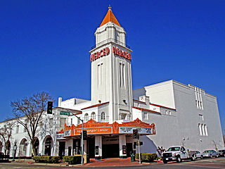
Atwater is a city on State Route 99 in Merced County, California, United States. Atwater is 8 miles (13 km) west-northwest of Merced, at an elevation of 151 feet. The population as of the 2010 census was 28,168.

The Merced River, in the central part of the U.S. state of California, is a 145-mile (233 km)-long tributary of the San Joaquin River flowing from the Sierra Nevada into the San Joaquin Valley. It is most well known for its swift and steep course through the southern part of Yosemite National Park, where it is the primary watercourse flowing through Yosemite Valley. The river's character changes dramatically once it reaches the plains of the agricultural San Joaquin Valley, where it becomes a slow-moving meandering stream.

The University of California, Merced, is the tenth and newest of the University of California campuses. The public research university is located in the San Joaquin Valley in Merced County, California, just northeast of the city of Merced, and between Modesto, California and Fresno, California. Most UC Merced students are from California with enrollment nearly evenly divided between Southern California, the Central Valley, and Northern California.

Lake Merced is a freshwater lake in the southwest corner of San Francisco, in the U.S. state of California. It is surrounded by three golf courses, as well as residential areas, Lowell High School, San Francisco State University, Lakeshore Alternative Elementary School, Stonestown Galleria, Fort Funston and the Pacific Ocean. The San Francisco Police Department shooting range, as well as a skeet shooting club and the city's National Guard armory are also in the area. The lake is home of the Pacific Rowing Club and St. Ignatius College Prep Rowing Team, both competitive rowing programs for San Francisco high school students.

Central California is a subregion of Northern California, generally thought of as the middle third of the state, north of Southern California. It includes the northern portion of the San Joaquin Valley, the Central Coast, the central hills of the California Coast Ranges, and the foothills and mountain areas of the central Sierra Nevada.

El Nido is a census-designated place in Merced County, California. It is located 15 miles (24 km) west-southwest of Le Grand, at an elevation of 141 feet, and a population of 160 The population was 330 at the 2010 census.

The Merced Sun-Star is a daily broadsheet newspaper printed in Merced, California, in the United States. It has an estimated circulation of 20,000 copies. The newspaper is published every day except for Sundays.
Cressey is a census-designated place in Merced County, California. It is located 6 miles (9.7 km) north-northwest of Atwater, at an elevation of 167 feet. The population was 394 at the 2010 census.

Merced Falls is an unincorporated community in Merced County, California. It is located on the north bank of the Merced River 6 miles (9.7 km) east of Snelling, at an elevation of 348 feet . Merced Falls was named for a set of rapids on the Merced River.

Briceburg is an unincorporated community in Mariposa County, California. It is located on the Merced River near the confluence with Bear Creek, 5 miles (8 km) north-northwest of Midpines, at an elevation of 1138 feet. It is accessed via a bridge over the Merced River that connects Highway 140 with Briceburg Road.
Bear Creek is a census-designated place in Merced County, California. It is located 3.5 miles (5.6 km) east of Merced, at an elevation of 190 feet. The population was 290 at the 2010 census.
Bellevue is a former settlement in Merced County, California. It was located on the Yosemite Valley Railroad 4 miles (6.4 km) north of Merced, at an elevation of 177 feet. Bellevue still appeared on USGS maps as of 1917.
Buhach is an unincorporated community in Merced County, California. It is located 2 miles (3.2 km) east-southeast of Atwater, at an elevation of 157 feet.
Cuba is a former settlement in Merced County, California. It was located on the Atchison, Topeka and Santa Fe Railroad 2.25 miles (3.6 km) east-northeast of Atwater, at an elevation of 167 feet. Cuba still appeared on USGS maps as of 1918.
Fluhr is an unincorporated community in Merced County, California. It is located on the Atchison, Topeka and Santa Fe Railroad 2 miles (3.2 km) east-northeast of Atwater, at an elevation of 174 feet.
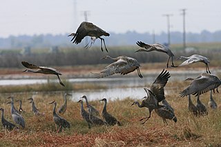
The Merced National Wildlife Refuge encompasses 10,262 acres (41.53 km2) of wetlands, native grasslands, vernal pools, and riparian areas in California. It was established in 1951 under the Lea Act to attract wintering waterfowl from adjacent farmland where their foraging was causing crop damage. In the last few decades, changes in agricultural practices and refuge management have reduced these wildlife/crop issues.

Merced College is a public community college in Merced, California.

Adam C. Gray is an American politician currently serving in the California State Assembly. He is a Democrat representing the 21st Assembly District, encompassing all of Merced County and portions of Stanislaus County.