
Diamond Springs is a census-designated place (CDP) in El Dorado County, California, United States. It is part of the Sacramento–Arden-Arcade–Roseville Metropolitan Statistical Area. The population was 11,037 at the 2010 census, up from 4,888 at the 2000 census. The town is registered as California Historical Landmark number 487. It lies at an elevation of 1791 feet.
Alondra Park, also known as El Camino Village, is a census designated place (CDP) in the South Bay region of Los Angeles County, California, United States. It is the unincorporated area north of Alondra Community Regional Park and El Camino College. It is east of Lawndale, south of Hawthorne, west of Gardena, and north of Torrance. Manhattan Beach Boulevard and Crenshaw Boulevard are the two major cross streets in the area. The population was 8,569 at the 2020 census, down from 8,592 at the 2010 census. There is an official Alondra Park Post Office of the U.S. Postal Service in nearby Gardena, California. Urbanized cement-lined Dominguez Creek bisects a portion of Alondra Park.
Delhi is a census-designated place (CDP) in Merced County in the U.S. state of California. Delhi is 18 miles (29 km) west-northwest of Merced, at an elevation of 118 feet (36 m). According to the 2020 census, the population was 10,656.

Hilmar-Irwin is a census-designated place (CDP) in Merced County, California, United States. As of the 2020 census, the population was 5,164.

Le Grand is an unincorporated community and census-designated place (CDP) in Merced County, California, United States. Le Grand is 14 miles (23 km) east-southeast of Merced, the county seat at an elevation of 253 feet (77 m). The population was 1,592 at the 2020 census, down from 1,659 at the 2010 census.

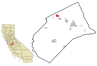
Planada is a census-designated place (CDP) in Merced County, California, United States. Planada is 9 miles (14 km) east of Merced, the county seat, at an elevation of 226 feet (69 m). The population was 4,164 at the 2020 census, down from 4,584 at the 2010 census.

South Dos Palos is an unincorporated community and census-designated place (CDP) in Merced County, California, United States. It is located 2 miles (3 km) southwest of Dos Palos at an elevation of 118 feet (36 m). The population was 1,747 at the 2020 census, up from 1,620 at the 2010 census.

Winton is an unincorporated community and census-designated place (CDP) in Merced County, California, United States. Winton is located 2.5 miles (4 km) north of Atwater, California. and 10 miles (16 km) northwest of Merced, the county seat. Winton was established along the original Santa Fe Railroad. At one time, passenger trains would stop at this location.

El Cerrito is a census-designated place (CDP) in Riverside County, California, United States. It is an unincorporated area mostly surrounded by the city of Corona. The population was 5,100 at the 2010 census, up from 4,590 at the 2000 census.

El Portal is a census-designated place in Mariposa County, California, United States. It is located 11.5 miles (19 km) west-southwest of Yosemite Village, at an elevation of 1,939 feet (591 m). The population was 372 at the 2020 census, down from 474 at the 2010 census.

Ballico is a census-designated place in Merced County, California, United States. It is located 9 miles (14 km) northwest of Atwater at an elevation of 151 feet. The population was 347 at the 2020 United States census, down from 406 in 2010.
Cressey is a census-designated place in Merced County, California. It is located 6 miles (9.7 km) north-northwest of Atwater, at an elevation of 167 feet. The population was 366 at the 2020 United States census, down from 393 in 2010.
Snelling is an unincorporated community and census-designated place (CDP) in Merced County, California, United States. It is located on the north bank of the Merced River 17 miles (27 km) north of Merced, at an elevation of 256 feet (78 m). The population was 238 at the 2020 census.
Midpines is a census-designated place in Mariposa County, California. It lies among the Sierra Nevada foothills of the central part of the state at an elevation of 2,585 feet (788 m), 5 miles (8 km) northeast of Mariposa, the county seat, and 22 miles (35 km) by road southwest of El Portal. It is composed of scattered residential areas along both sides of State Route 140, which is one of three principal routes to Yosemite National Park, some 30 miles (48 km) to the east of Midpines. The population was 379 at the 2020 census, down from 1,204 in 2010, when the CDP was drawn to cover significantly more area.
Bear Creek is a census-designated place in Merced County, California. It is located 3.5 miles (5.6 km) east of Merced, at an elevation of 190 feet. The population was 273 at the 2020 United States census, down from 290 at the 2010 census.
Stevinson is an unincorporated community and census-designated place in Merced County, California. It is located 21 miles (34 km) west of Merced at an elevation of 85 feet (26 m). The population was 275 at the 2020 census, down from 313 at the 2010 census.
Tuttle is an unincorporated community and census-designated place (CDP) in Merced County, California, United States. It is located on the Atchison, Topeka and Santa Fe Railroad 6 miles (10 km) east of Merced, the county seat, at an elevation of 207 feet (63 m). The population was 102 at the 2020 census.

Lake Don Pedro is a census-designated place (CDP) in Mariposa County, California. The community sits at an elevation of 1,122 feet (342 m). As of the 2020 United States census, the population was 1,765.
McSwain is an unincorporated community and census-designated place (CDP) in Merced County, California, United States. McSwain sits at an elevation of 144 feet (44 m). As of the 2020 census, the population was 4,480, up from 4,171 in 2010.
Franklin is a census-designated place in Merced County, California, United States, sitting at an elevation of 161 feet (49 m). As of the 2020 census the population was 6,919, up from 6,149 in 2010.


