| Bronson Creek Airport | |||||||||||
|---|---|---|---|---|---|---|---|---|---|---|---|
| Summary | |||||||||||
| Operator | |||||||||||
| Serves | Snip Gold Mine | ||||||||||
| Location | Bronson Creek, British Columbia | ||||||||||
| Time zone | PST (UTC−08:00) | ||||||||||
| • Summer (DST) | PDT (UTC−07:00) | ||||||||||
| Elevation AMSL | 500 ft / 152 m | ||||||||||
| Coordinates | 56°40′47″N131°05′15″W / 56.67972°N 131.08750°W Coordinates: 56°40′47″N131°05′15″W / 56.67972°N 131.08750°W | ||||||||||
| Map | |||||||||||
| Runways | |||||||||||
| |||||||||||
Source: Canada Flight Supplement [1] | |||||||||||
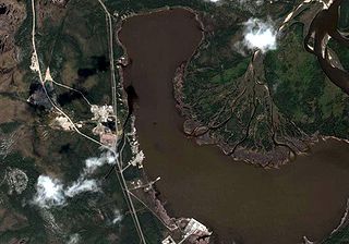
Bronson Creek Airport( IATA : YBM, TC LID : CAB5) was an airport in Bronson Creek, British Columbia, Canada. [2] [3] [4] [5]
An IATA airport code, also known as an IATA location identifier, IATA station code or simply a location identifier, is a three-letter code designating many airports around the world, defined by the International Air Transport Association (IATA). The characters prominently displayed on baggage tags attached at airport check-in desks are an example of a way these codes are used.

Transport Canada is the department within the Government of Canada responsible for developing regulations, policies and services of transportation in Canada. It is part of the Transportation, Infrastructure and Communities (TIC) portfolio. The current Minister of Transport is Marc Garneau. Transport Canada is headquartered in Ottawa, Ontario.
A location identifier is a symbolic representation for the name and the location of an airport, navigation aid, or weather station, and is used for manned air traffic control facilities in air traffic control, telecommunications, computer programming, weather reports, and related services.
The airport was built to service the Snip Gold Mine which closed in 1999. [6] The Transport Canada location identifier is now used by Abbotsford (Regional Hospital & Cancer Centre) Heliport.


