Related Research Articles

Colorado is a state in the Mountain West subregion of the Western United States. It encompasses most of the Southern Rocky Mountains, as well as the northeastern portion of the Colorado Plateau and the western edge of the Great Plains. Colorado is the eighth most extensive and 21st most populous U.S. state. The 2020 United States Census enumerated the population of Colorado at 5,773,714, an increase of 14.80% since the 2010 United States Census.

Coconino County is a county located in the north-central part of the U.S. state of Arizona. Its population was 134,421 at the 2010 census. The county seat is Flagstaff. The county takes its name from Cohonino, a name applied to the Havasupai people. It is the second-largest county by area in the contiguous United States, behind San Bernardino County, California. It has 18,661 sq mi (48,300 km2), or 16.4% of Arizona's total area, and is larger than each of the nine smallest states in the U.S.

Sandoval County is located in the U.S. state of New Mexico. As of the 2010 census, the population was 131,561, making it the fourth-most populous county in New Mexico. The county seat is Bernalillo.
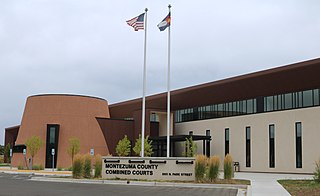
Montezuma County is the southwesternmost of the 64 counties in the U.S. state of Colorado. As of the 2020 census, the population was 25,849. The county seat is Cortez.

Chaffee County is one of the 64 counties of the U.S. state of Colorado. As of the 2020 census, the population was 19,476. The county seat is Salida.

Glencoe is a town in Buffalo County in the U.S. state of Wisconsin. The population was 485 at the 2010 census. The unincorporated community of Glencoe is located in the town.

The Royal Gorge is a canyon of the Arkansas River located west of Cañon City, Colorado. The canyon begins at the mouth of Grape Creek, about 2 mi (3.2 km) west of central Cañon City, and continues in a west-northwesterly direction for approximately 6 mi (9.7 km) until ending near U.S. Route 50. Being one of the deepest canyons in Colorado, it is also known as the Grand Canyon of the Arkansas (River), with a maximum depth of 1,250 ft (380 m). The canyon is also very narrow, measuring from 50 ft (15 m) wide at its base to 300 ft (91 m) wide at its top, as it carves a path through the granite formations below Fremont Peak and YMCA Mountain, which rise above the north and south rims, respectively.

The Four Corners is a region of the Southwestern United States consisting of the southwestern corner of Colorado, southeastern corner of Utah, northeastern corner of Arizona, and northwestern corner of New Mexico. The Four Corners area is named after the quadripoint at the intersection of approximately 37° north latitude with 109° 03' west longitude, where the boundaries of the four states meet, and are marked by the Four Corners Monument. It is the only location in the United States where four states meet. Most of the Four Corners region belongs to semi-autonomous Native American nations, the largest of which is the Navajo Nation, followed by Hopi, Ute, and Zuni tribal reserves and nations. The Four Corners region is part of a larger region known as the Colorado Plateau and is mostly rural, rugged, and arid. In addition to the monument, commonly visited areas within Four Corners include Monument Valley, Mesa Verde National Park, Chaco Canyon, Canyons of the Ancients National Monument and Canyon de Chelly National Monument. The most populous city in the Four Corners region is Farmington, New Mexico, followed by Durango, Colorado.
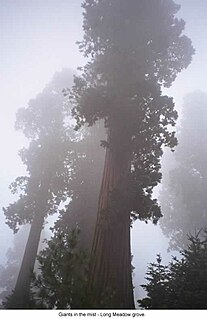
Sequoia National Forest is located in the southern Sierra Nevada mountains of California. The U.S. National Forest is named for the majestic Giant Sequoia trees which populate 38 distinct groves within the boundaries of the forest.

Skeleton Canyon, called Cañon Bonita by the Mexicans, is located 30 miles (50 km) northeast of the town of Douglas, Arizona, in the Peloncillo Mountains, which straddle the modern Arizona and New Mexico state line, in the New Mexico Bootheel region.
The Wave is a sandstone rock formation located in Arizona, United States, near its northern border with Utah. The formation is situated on the slopes of the Coyote Buttes in the Paria Canyon-Vermilion Cliffs Wilderness of the Colorado Plateau. The area is administered by the Bureau of Land Management (BLM) at the Grand Staircase-Escalante National Monument visitor center in Kanab, Utah.

Swan Township is located in Warren County, Illinois, United States. As of the 2010 census, its population was 265 and it contained 126 housing units.

Eckerty is an unincorporated community in Johnson Township, Crawford County, Indiana.

The Shinarump Conglomerate is a geologic formation found in the Four Corners region of the United States. It was deposited in the early part of the Late Triassic period.

The Trail of the Ancients is a New Mexico Scenic Byway to prehistoric archaeological and geological sites of northwestern New Mexico. It provides insight into the lives of the Ancestral Puebloans and the Navajo, Ute, and Apache peoples. Geological features include canyons, volcanic rock features, and sandstone buttes. Several of the sites are scenic and wilderness areas with recreational opportunities.

Browns Canyon National Monument is a 21,586 acres (87 km2) national monument in Chaffee County, Colorado, that was designated as such by President Barack Obama under the Antiquities Act on February 19, 2015. The site will be centered along the Arkansas River between Buena Vista and Salida. Browns Canyon is the most popular destination for whitewater rafting in the country, and is also known for its fishing and hiking. The monument will provide habitat protection for bighorn sheep, peregrine falcons, elk, and golden eagles.
Lime Canyon Wilderness is a unit of the National Wilderness Preservation System located in eastern Nevada, United States, within the Gold Butte National Monument. The 23,710-acre (9,600 ha) wilderness area is administered by the Bureau of Land Management, and was designated in 2002 to protect roadless, undeveloped mountains bordering Lake Mead National Recreation Area.
References
- ↑ "Browns Canon Populated Place Profile". HTL, Inc. Retrieved 28 April 2013.
- ↑ "Browns Canon, United States". ITA. Retrieved 28 April 2013.
- ↑ Sheppard, Kate (19 February 2015). "Obama Will Designate 3 New National Monuments". Huffington Post . Retrieved 19 February 2015.
- ↑ "Browns Canon". Geographic Names Information System . United States Geological Survey.
Municipalities and communities of Chaffee County, Colorado, United States | ||
|---|---|---|
| City | 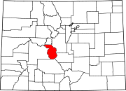 | |
| Towns | ||
| CDPs | ||
| Unincorporated communities | ||
Coordinates: 38°36′43″N106°03′36″W / 38.61194°N 106.06000°W
| | This Colorado-related article is a stub. You can help Wikipedia by expanding it. |