Buchanan Township | |
|---|---|
 | |
| Coordinates: 40°33′52″N95°39′31″W / 40.5644224°N 95.6586419°W | |
| Country | |
| State | |
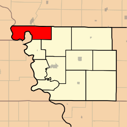
| County | Atchison |
| Area | |
• Total | 108.8 km2 (42.02 sq mi) |
| • Land | 106.8 km2 (41.25 sq mi) |
| • Water | 2.0 km2 (0.77 sq mi) 1.83% |
| Elevation | 276 m (906 ft) |
| Population | |
• Total | 65 |
| • Density | 0.6/km2 (1.6/sq mi) |
| FIPS code | 29-00509244 [1] |
| GNIS feature ID | 766231 [2] |
Buchanan Township is a township in Atchison County, Missouri, United States. [2] At the 2020 census, its population was 65. [3] The northwest corner of the township is the northwest corner of the entire state.
Contents
Buchanan Township was established in 1858, and named after James Buchanan, the 15th President of the United States. [4]
