
Lanzenkirchen is a market town in the district of Wiener Neustadt-Land in the Austrian state of Lower Austria.

Thalheim bei Wels is a town in the Wels-Land District in the Austrian state of Upper Austria.

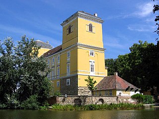
Laxenburg is a market town in the district of Mödling, in the Austrian state of Lower Austria. Located about 20 km (12 mi) south of the Austrian capital Vienna, it is chiefly known for the Laxenburg castles, which, beside Schönbrunn, served as the most important summer retreat of the Habsburg monarchs.

For the town in Germany, see Mistelbach, Bavaria.

Liezen is a municipality in the Austrian federal state of Styria, district capital of the district of the same name and economic center on the River Enns.

Hauskirchen is a town in the district of Gänserndorf in the Austrian state of Lower Austria.
Mailberg is a town in the district of Hollabrunn in Lower Austria, Austria. First mentioned in records in 1055 Castle Mailberg is owned and run by the Austrian Grand Priory of the Sovereign Military Order of Malta since 1146. It is known for its wine production and now serves as a castle hotel and as Vinothek for the local Winemakers Community "Mailberg Valley".

Bernhardsthal is a town in the district of Mistelbach in the Austrian state of Lower Austria.

Falkenstein is a town in the district of Mistelbach in the Austrian state of Lower Austria.
Hochleithen is a municipality in the district of Mistelbach in the Austrian state of Lower Austria.

Wilfersdorf is a town in the district of Mistelbach in the Austrian state of Lower Austria.
Wolkersdorf im Weinviertel is a town in the district of Mistelbach in the Austrian state of Lower Austria. It is situated in the Weinviertel, about 15 km north of Vienna, on the main road from Vienna to Brno. The municipality consists of the subdivisions Wolkersdorf, Riedenthal, Pfösing, Obersdorf and Münichsthal. It was elevated to town status in 1969.
Voitsberg is a small city in the district of Voitsberg in Styria, Austria, with a population of c. 9,700 as of 2009. It grew upon the St. Margaret church at the Tregistbach river and was first mentioned in 1220 as Civitas. Remains of the Greisenegg palace and Obervoitsberg castle can be seen. Other objects of interest are its Cityhall Voitsberg, designed by architect Arik Brauer.
Volders is a municipality in the district of Innsbruck-Land in the Austrian state of Tyrol located 12 km east of Innsbruck on the southern side of the Inn River. Sights are Schloss Friedberg and Schloss Aschach and the church of Saint Charles Borromeo, attached to a Servite convent.
Eferding (help·info) is the capital of the Eferding district in the Austrian state of Upper Austria.

Kefermarkt is a municipality in the district of Freistadt in the Austrian state of Upper Austria. The church in Kefermarkt houses the late medieval Kefermarkt Altarpiece.
Vorchdorf is a market town in the district of Gmunden in Upper Austria, Austria, as well as the name of the municipal area ("Gemeinde") that the town and others occupy. As of the 2005 census, the town of Vorchdorf had a population of 7,287 inhabitants.

Gallspach is a municipality and spa in the district of Grieskirchen in the Austrian state of Upper Austria. Centre of the municipality ist the market town Gallspach. It comprises also the following villages: Enzendorf, Gferedt, Niederndorf, Schützendorf, Thall, Thongraben, Vornwald and Wies.
Sankt Gotthard im Mühlkreis is a municipality in the district of Urfahr-Umgebung in Upper Austria, Austria.

Ragnitz is a municipality in the district of Leibnitz in Styria, Austria. Three castles are within the territories of Ragnitz : Schloss Frauheim, Schloss Laubegg and Schloss Rohr


