Lambach is a market town in the Wels-Land district of the Austrian state of Upper Austria on the Ager and Traun Rivers. A major stop on the salt trade, it is the site of the Lambach Abbey, built around 1056. Notable alumnus from the local elementary school is Adolf Hitler, who attended the establishment in the 1890s.

Weiden bei Rechnitz is a town in the district of Oberwart in the Austrian state of Burgenland.

Furth bei Göttweig is a town and municipality in the district of Krems-Land in the Austrian state of Lower Austria. The municipality consists of the following populated places:

Reith bei Seefeld is a municipality in the district of Innsbruck-Land in the Austrian state of Tyrol located 12.3 km northwest of Innsbruck and 3 km south of Seefeld in Tirol.

Hof bei Salzburg is a municipality in the district of Salzburg-Umgebung in the state of Salzburg in Austria.

St. Georgen bei Salzburg is a municipality in the district of Salzburg-Umgebung in the state of Salzburg in Austria.
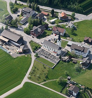
Langen bei Bregenz is a municipality in the district of Bregenz in the Austrian state of Vorarlberg.

Feldkirchen bei Mattighofen is a municipality in the Braunau am Inn district in the Austrian state of Upper Austria. It is home to the Berglandmilch dairy, the largest cheese dairy in Austria.

Kirchberg bei Mattighofen is a municipality in the district of Braunau am Inn in the Austrian state of Upper Austria.

Sankt Oswald bei Freistadt is a municipality in the district of Freistadt in Austrian state of Upper Austria.

Windhaag bei Freistadt is a municipality in the district of Freistadt in the Austrian state of Upper Austria.

Windhaag bei Perg is a municipality in the district of Perg in the Austrian state of Upper Austria.

St. Georgen bei Obernberg am Inn is a municipality in the district of Ried in the Austrian state of Upper Austria.

Sankt Oswald bei Haslach is an Austrian municipality located in the state of Upper Austria in the district of Rohrbach.

Andorf is a municipality in the district of Schärding in Upper Austria, Austria. As of 2024, it had a population of 5,218.

Altenberg bei Linz is a municipality in the district of Urfahr-Umgebung in the Mühlviertel region in the Austrian state of Upper Austria.

Kirchschlag bei Linz is a municipality in the district of Urfahr-Umgebung in the Austrian state of Upper Austria.
Oberndorf bei Schwanenstadt is a municipality in the district of Vöcklabruck in the Austrian state of Upper Austria.

Neukirchen bei Lambach is a municipality in the district of Wels-Land in the Austrian state of Upper Austria.

Pichl bei Wels is a municipality in the district of Wels-Land in the Austrian state of Upper Austria.