
Eureka is a city located in St. Louis County, Missouri, United States, adjacent to the cities of Wildwood and Pacific, along Interstate 44. It is in the extreme southwest of the Greater St. Louis metro area. As of the 2010 census, the city had a population of 10,189. Since 1971, Eureka has been known as the home of the amusement park Six Flags St. Louis.

St. Louis County is located in the eastern-central portion of Missouri. It is bounded by the City of St. Louis and the Mississippi River to the east, the Missouri River to the north, and the Meramec River to the south. As of the 2019 Census Bureau population estimate, the population was 994,205, making it the most populous county in Missouri. Its county seat is Clayton. The county is included in the St. Louis, MO–IL metropolitan statistical area.

Arnold is the largest city in Jefferson County, Missouri, United States. The population was 20,808 at the 2010 census.

Fenton is a city in St. Louis County, Missouri, United States, and a suburb of St. Louis. The population was 4,022 at the 2010 census.

Valley Park is a city in St. Louis County, Missouri, United States. The population was 6,942 at the 2010 census.

Pacific is a city in the U.S. state of Missouri in eastern Franklin County and extending to the east into southwest St. Louis County. The population was 7,002 at the 2010 census.

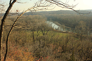
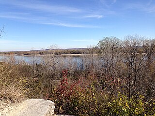
The Meramec River, sometimes spelled Maramec River, is one of the longest free-flowing waterways in the U.S. state of Missouri, draining 3,980 square miles (10,300 km2) while wandering 218 miles (351 km) from headwaters near Steelville to where it empties into the Mississippi River near St. Louis at Arnold and Oakville. The Meramec watershed covers six Missouri Ozark Highland counties—Dent, Phelps, Crawford, Franklin, Jefferson, and St. Louis—and portions of eight others—Maries, Gasconade, Iron, Washington, Reynolds, St. Francois, Ste. Genevieve, and Texas. Between its source and its mouth, it falls 1,025 feet (312 m). Year-round navigability begins above Maramec Spring, just south of St. James. The Meramec's size increases at the confluence of the Dry Fork, and its navigability continues until the river enters the Mississippi at Arnold, Missouri.
Route 141, also known as Woods Mill Road in parts of St. Louis County, is a state highway located in the western St. Louis metropolitan area. Its northern terminus is at Route 370 in Bridgeton; its southern terminus is at U.S. Route 61/U.S. Route 67 in Arnold, in Jefferson County. The northern stretches of the highway are often referred to as the Maryland Heights Expressway or Earth City Expressway.

Meramec State Park is a public recreation area located near Sullivan, Missouri, about 60 miles from St. Louis, along the Meramec River. The park has diverse ecosystems such as hardwood forests and glades. There are over 40 caves located throughout the park, the bedrock isdolomite. The most famous is Fisher Cave, located near the campgrounds. The park borders the Meramec Conservation Area.

Johnson's Shut-Ins State Park is a public recreation area covering 8,781 acres (3,554 ha) on the East Fork Black River in Reynolds County, Missouri. The state park is jointly administered with adjoining Taum Sauk Mountain State Park, and together the two parks cover more than sixteen thousand acres in the St. Francois Mountains region of the Missouri Ozarks.

Sherman is an unincorporated community in western St. Louis County, Missouri, United States. It is located on the Meramec River, approximately three miles northeast of Eureka. Sherman formerly had a post office, but mail now comes from Ballwin.
Castlewood State Park is a public recreation area and Missouri state park occupying 1,818 acres (736 ha) which straddle the Meramec River in St. Louis County, Missouri. The most visited section of the state park lies on the north side of the Meramec; the park acreage on the south side of the river is accessed from Lone Elk County Park and includes the World Bird Sanctuary.
In the U.S. state of Missouri, Interstate 55 (I-55) runs from the Arkansas state line to the Poplar Street Bridge over the Mississippi River in St. Louis.

The Great Rivers Greenway District is a public agency created in 2000 to develop a regional network of greenways. Great Rivers Greenway engages citizens and community partners to plan, build and care for the greenways. In its first 20 years the agency built more than 128 miles of greenways connecting parks, rivers, schools, neighborhoods, business districts and transit.

Robertsville State Park is a public recreation area bordering the Meramec River in unincorporated Robertsville in Franklin County, Missouri. The state park's 1,225 acres (496 ha) include a boat launch, campground, playground, picnic shelters, and the Spice Bush and Lost Hill hiking trails. The land was once owned by Edward James Roberts, who moved to the area at age 14 in 1831.

Emmenegger Nature Park (ENP) consists of 93 acres (0.38 km2) in southwestern St. Louis County, Missouri. It is located in the city of Kirkwood and bordered to the west by the Meramec River, to the south by Interstate 44 and the Possum Woods Conservation Area, and to the east by Interstate 270. The ENP is part of the Henry Shaw Ozark Corridor. The Powder Valley Nature Center is directly to the east of ENP across Interstate 270.
Cliff Cave County Park is a 525-acre public park located in St. Louis, Missouri. The park is operated by St. Louis County Parks. It is named after Cliff Cave, a natural cave located in the park that is a historical and archaeologic site. The park contains woodlands, wetlands, and rocky hillsides and is adjacent to the Mississippi River. It has three trails: the Mississippi Trail, the Spring Valley Trail, and the River Bluff Trail. The Riverside Shelter overlooks the Mississippi River. An active train track runs through the park. Cliff Cave Park is part of the Mississippi River Greenway. The park won the "Best View of the Mississippi" award in 2009, which it was granted by The Riverfront Times.
Indian Camp Creek Park is a public park in Foristell, Missouri. It is located in the northwestern part of St. Charles County and is operated by the St. Charles County Parks Department. It is the county's largest park at 603 acres.
Bohrer Park is a park located in St. Louis County, Missouri. The park is owned and administered by the St. Louis County Department of Parks and Recreation.
Cliff Cave Park is a park located in St. Louis County, Missouri. The park is owned and administered by the St. Louis County Department of Parks and Recreation. The park is located alongside the Mississippi River.