
Scouting in Missouri has a long history, from the 1910s to the present day.

St. Charles County is in the central eastern part of the U.S. state of Missouri. As of the 2010 census, the population was 360,485, making it Missouri's third-most populous county. Its county seat is St. Charles. The county was organized October 1, 1812 and named for Saint Charles Borromeo, an Italian cardinal. The county executive is Steve Ehlmann, since January 2007.

St. Peters is a city in St. Charles County, Missouri, United States. The 2010 census showed the city's population to be 52,575, tied for 10th place in Missouri with Blue Springs.

The Katy Trail State Park is a state park in the U.S. state of Missouri that contains the Katy Trail, the country's longest recreational rail trail. It runs 240 miles (390 km), largely along the northern bank of the Missouri River, in the right-of-way of the former Missouri–Kansas–Texas Railroad. Open year-round from sunrise to sunset, it serves hikers, joggers, and cyclists. Its hard, flat surface is of "limestone pug".

Fort Sheridan is a residential neighborhood within the cities of Lake Forest, Highwood, and Highland Park in Lake County, Illinois, United States. It was originally established as Fort Sheridan, an Army post named after Civil War cavalry general Philip Sheridan, to honor his services to Chicago.
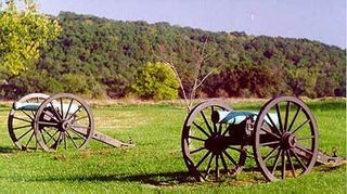
Wilson's Creek National Battlefield, located near Republic, Missouri, preserves the site of the Battle of Wilson's Creek. Fought on August 10, 1861, the battle was the first major American Civil War engagement west of the Mississippi River. In the battle, a Confederate army commanded by Benjamin McCulloch and Sterling Price defeated a smaller Union army commanded by Nathaniel Lyon. However, the Confederates were unable to hold much of Missouri, and a Confederate defeat at the Battle of Pea Ridge effectively solidified Union control of the state. Major features include a five-mile automobile tour loop, the restored 1852 Ray House, and "Bloody Hill," the site of the final stage of the battle. The site is located near Republic in southwestern Missouri just southwest of the city of Springfield. It has been a unit of the National Park Service since 1960, and was listed on the National Register of Historic Places in 1966.

The Irish Wilderness is a 16,227-acre (66 km2) wilderness area in the U.S. State of Missouri. The U.S. Congress designated it a wilderness in 1984. The Irish Wilderness is located within the Eleven Point Ranger District of the Mark Twain National Forest, 10 miles (16 km) northeast of Alton, Missouri. The Irish Wilderness is one of eight wilderness areas protected and preserved in Missouri.

Hawn State Park is a public recreation area located 14 miles (23 km) southwest of Ste. Genevieve, Missouri. The state park's nearly 5,000 acres (2,000 ha) include three state-designated natural areas: Pickle Creek, LaMotte Sandstone Barrens, and Botkins Pine Woods. Orchid Valley is also considered part of Hawn State Park, but is not connected to the rest of the park and is not open to the public.

Babler State Park is a state-managed public recreation area located in the northwest section of the city of Wildwood, Missouri. A large bronze statue of Dr. Babler greets park visitors. The state park's 2,441 acres (988 ha) offer opportunities for hiking, picnicking, bicycling, horseback riding, and camping. The park was added to the National Register of Historic Places in 1985.

Cuivre River State Park is a public recreation area covering more than 6,400 acres (2,600 ha) northeast of the city of Troy in the Lincoln Hills region of northeastern Missouri, United States. The state park's rugged landscapes range from native grasslands and savannas to limestone bluffs over looking forested hills. The park offers an extensive system of hiking trails plus swimming and camping facilities and is managed by the Missouri Department of Natural Resources. It encompasses the Lincoln Hills Natural Area and two designated wild areas: Big Sugar Creek and Northwoods.
San Mateo County's Memorial Park is located in Loma Mar and is operated by the San Mateo County Department of Parks. The park encompasses 673 acres (2.72 km2), and includes old-growth redwood trees, eight miles (13 km) of hiking trails, camping areas, picnic facilities, a visitor center, a camp store, a creek swimming area, and campfire programs. Pescadero Creek, which provides winter habitat for steelhead trout, runs through the park. Bloomquist, Hoffman, McCormick, and Peterson Creeks join Pescadero Creek within the park boundaries.

Graham Cave State Park is a state park in the U.S. state of Missouri consisting of 369 acres (149 ha) located in Montgomery County. The park's namesake, Graham Cave, is a cave in St. Peter sandstone with an entrance 120 feet (37 m) wide and 60 feet (18 m) high and an extent of about 100 feet (30 m) into the hillside. The cave protects an historically important Pre-Columbian archaeological site dating back to as early as 10,000 years ago. Visitors are allowed up to the entrance of the cave where interpretive signs point out significant discoveries. The park includes the 82-acre (33 ha) Graham Cave Glades Natural Area which protects an area of sandstone and dolomite glades with a rich diversity of glade species. The park is adjacent to Interstate 70 from which the entrance to the cave can be glimpsed during foliage-free months.

Devil's Den State Park is a 2,500-acre (1,000 ha) Arkansas state park in Washington County, near West Fork, Arkansas in the United States. The park was built by the Civilian Conservation Corps, beginning in 1933. Devil's Den State Park is in the Lee Creek Valley in the Boston Mountains, which are the southwestern part of The Ozarks. The park, with an 8 acres (3.2 ha) CCC-built lake, is open for year-round recreation, with trails for hiking, mountain biking and horseback riding. Devil's Den State Park also has several picnic areas, a swimming pool and cabins, with camping sites ranging from modern to primitive. Fossils of coral and crinoids can be found along the banks and within Lee Creek at Devil's Den State Park.
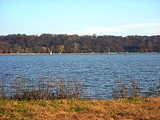
Creve Coeur Lake Memorial Park is a 2,145-acre (8.68 km2) St. Louis County park located in Maryland Heights, Missouri, United States. The park is the largest in the St. Louis County Parks system and includes Creve Coeur Lake, an oxbow lake which is one of the largest natural lakes in Missouri. The park has facilities for picnicking, tennis courts, multi-purpose athletic fields, and an archery course. Creve Coeur Park includes Crystal Springs Quarry Golf Course, an 18-hole course opened in 2001. In December 2003, construction for the Creve Coeur Lake Memorial Park Bridge, which is part of Missouri Route 364, was completed. The concrete bridge connects St. Louis County to St. Charles County and crosses over the southern end of the park. The project also included Creve Coeur Lake being dredged and the addition of a siltation lake to prevent the need for later dredging. Creve Coeur Lake Memorial Park has an asphalt walking trail around the lake, which was constructed by the Missouri Department of Transportation alongside the bridge project. The trail also connects to a separate lane on the bridge leading across the Missouri River to connect to the Katy Trail. A large portion of the park and surrounding area is also wetlands, and the park has been used for conservation purposes, particularly the study of various waterfowl.

Indian Cave State Park is a public recreation and historic preservation area covering nearly 3,400 acres (1,400 ha) along the Missouri River in southeast Nebraska. The state park preserves a cave with prehistoric petroglyphs as well as the partially reconstructed village of St. Deroin established in 1853 as part of the former Nemaha Half-Breed Reservation. The state park lies ten miles (16 km) south of Brownville and eight miles (13 km) east of Shubert, straddling the county line between Nemaha and Richardson counties.

An extensive collection of parks and greenways exists in Huntsville, Alabama for the public's recreational use.

Red Rock Landing Conservation Area is located in eastern Perry County, Missouri at the end of County Road 350, approximately ten miles east of Perryville, Missouri. The Missouri Conservation Department created this area in November 1994 with the purchase of 554-acres along the Mississippi River.

Echo Bluff State Park is a public recreation area comprising 476 acres (193 ha) of land in Newton Township, Shannon County, Missouri, United States. The state park occupies the site of former Camp Zoe, a summer camp for children that opened in 1929. The park was named for the massive cliff that towers over one side of Sinking Creek.

Towne Park is a public park in Foristell, Missouri. It is operated by St. Charles County. The park, which opened on May 11, 2012, is named for the Towne family, who donated the land. It is the 10th park in the St. Charles County Parks system.
Quail Ridge Park is a public park in Wentzville, Missouri. It is operated by the St. Charles County Parks Department.
