University City is an inner-ring suburb of the city of St. Louis in St. Louis County, in the U.S. state of Missouri. The population was measured at 35,065 by the 2020 census.

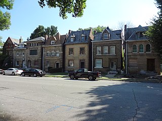
The Central West End is a neighborhood in St. Louis, Missouri, stretching from Midtown's western edge to Union Boulevard and bordering on Forest Park with its outstanding array of free cultural institutions. It includes the Cathedral Basilica of Saint Louis on Lindell Boulevard at Newstead Avenue, which houses the largest collection of mosaics in the world. The Central West End is represented by three aldermen as it sits partially in the 17th, 18th, and 28th Wards.
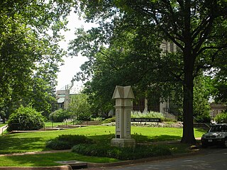
Wydown/Skinker is a neighborhood in St. Louis, Missouri. Washington University in St. Louis is located just north of this neighborhood. The neighborhood is bounded by the city limits on the west, Forsyth Boulevard on the north, Forest Park on the east and Clayton Avenue on the south. The Missouri Historical Society Library & Research Center is located in the Wydown/Skinker neighborhood.

Academy/Sherman Park is a neighborhood in North St. Louis, just outside Central West End. The official boundaries of the area are Dr. Martin Luther King Drive on the north, Delmar Boulevard on the south, North Kingshighway Boulevard on the east, and Union Boulevard on the west.

DeBaliviere Place is a neighborhood of St. Louis, Missouri.
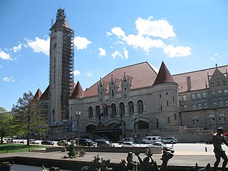
Downtown West is a neighborhood in St. Louis, Missouri. It is, as the name suggests, a section of downtown that is further inland, west from the banks of the Mississippi River. St. Louis City Hall, the Metropolitan Police Headquarters, St. Louis Union Station, Stifel Theatre, Enterprise Center, and the future St. Louis MLS stadium are all located in Downtown West. The Washington Avenue Historic District is a former garment district consisting of turn of the previous century high rise warehouses converted into residential lofts, restaurants, taverns, and coffee shops. It is bounded by Jefferson Avenue on the west, Tucker Boulevard on the east, Cole Street on the north, and Chouteau Avenue on the south.

Fairground is a neighborhood of St. Louis, Missouri. The neighborhood's boundaries are defined as Glasgow Avenue on the east, west and North Florissant Avenues on the north, Warne on the west, and Fairground Park and Natural Bridge Avenue on the south.
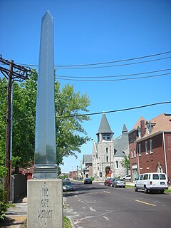
The Gate District is a neighborhood of St. Louis, Missouri. The Gate District is defined as the area between Chouteau Avenue and Interstate 44 on the north and south and between South Jefferson Avenue and South Grand Boulevard on the east and west. This area is just south of the central corridor and west of Lafayette Square. The term Gate was added to define this neighborhood due to the number of ironclad gates lining the streets. Today, the neighborhood is the subject of increased gentrification.

Hamilton Heights is a neighborhood of St. Louis, Missouri. The neighborhood is bounded by Dr. Martin Luther King Drive on the Northeast, the city limits on the Northwest, Page Avenue on the South, and Union Boulevard on the East.

JeffVanderLou (JVL) is a neighborhood of St. Louis, Missouri. The neighborhood is situated between North Vandeventer Avenue on the northwest, Natural Bridge Avenue on the northeast, North Jefferson Avenue on the East, Delmar Boulevard on the south, and North Compton Avenue and Martin Luther King Drive on the Southwest.

Skinker DeBaliviere is a neighborhood of St. Louis, Missouri located directly north of Forest Park. In addition to the park, its boundaries are Delmar Boulevard to the north, DeBaliviere Avenue to the east, and the western city limits. It is home to The Pageant, Pin-up Bowl, and all the other establishments of the Delmar Loop east of University City. It also includes the west end of the Forest Park – DeBaliviere and the entire Skinker MetroLink stations. The Delmar Loop station is just outside of its north boundary. In 1978, the neighborhood was designated a Local Historic District by the City of St. Louis, and the private subdivision of Parkview is listed in the National Register of Historic Places.

Lewis Place is a neighborhood of St. Louis, Missouri. Lewis Place is defined by Martin Luther King Drive on the North, Delmar Boulevard on the South, Newstead Avenue on the East, and Walton on the West.

North Hampton is a neighborhood of St. Louis, Missouri. Located in Southwest City, North Hampton is bounded by Scanlan and Connecticut to the north, South Kingshighway Boulevard to the east, Chippewa Street to the south, and Hampton Avenue to the west.

Near North Riverfront is a neighborhood of St. Louis, Missouri. Between 1990 and 2000 Near North Riverfront led the city in percentage population growth, growing 89% over the decade. Despite this large percentage growth, Near North Riverfront is largely non-residential and so the 89% percent gain represented a numerical gain of only 306 persons. The neighborhood is served by major city streets such as Tucker Boulevard, West Florissant Avenue, and Broadway Boulevard.

Penrose is a neighborhood of St. Louis, Missouri. The Penrose neighborhood is split with half of it in the city's 21st Ward. and the other half in the city's 1st Ward. The neighborhood is located on the north side of the city just south of Interstate 70 and west of O’Fallon Park. It is bounded by Florissant Avenue and I-70 on the north, Natural Bridge on the south, North Newstead and Pope Avenue on the east, and Kingshighway Boulevard on the west.
Vandeventer is a neighborhood of St. Louis, Missouri. The area is bounded by Dr. Martin Luther King Drive on the North, Delmar Boulevard on the South, Vandeventer Avenue on the East, and Newstead Avenue on the West.

Visitation Park is a neighborhood of St. Louis, Missouri. The neighborhood is defined by Maple Avenue on the North, Delmar Boulevard on the South, Union Boulevard on the East, and Belt Avenue on the West. Visitation Park is a small neighborhood nestled southeast of the West End neighborhood, just north of DeBaliviere Place.
Walnut Park West is a neighborhood of St. Louis, Missouri. The Walnut Park West neighborhood is situated in northwest St. Louis. It is bounded by West Florissant Avenue to the northeast, Riverview Boulevard to the southeast, Interstate Highway 70 (I-70) to the south, and the City limits to the west and northwest.

West End is a neighborhood of St. Louis, Missouri. This neighborhood is defined by Page Boulevard on the North, Delmar Boulevard on the South, Belt Avenue and Union Boulevard via Maple Avenue on the East, and City limits on the West. The neighborhood is home to the Emmanuel DeHodiamont House, one of the two oldest houses in St. Louis.