Forest Park Southeast, St. Louis

Last updated
Forest Park Southeast
The Grove (10602410245).jpg
The Grove, Forest Park Southeast, October 2013
STL Neighborhood Map 39.PNG
Location (red) of Forest Park Southeast within St. Louis
Country United States
State Missouri
City St. Louis
Wards 17
Area
  Total0.64 sq mi (1.7 km2)
Population
 (2020) [1]
  Total3,458
  Density5,400/sq mi (2,100/km2)
ZIP code(s)
Part of 63110
Area code(s) 314
Website stlouis-mo.gov

Forest Park Southeast (FPSE) is a neighborhood of St. Louis, Missouri. It is bordered by Interstate 64 (U.S. Route 40) to the north, Vandeventer Avenue to the east, Interstate 44 to the south, and Kingshighway Boulevard and Forest Park to the west. Adjoining neighborhoods include Kings Oak and The Hill to the west, Southwest Garden to the south, Botanical Heights to the southeast, Midtown to the east, and the Central West End to the north.

Contents

The commercial district along Manchester Avenue, which bisects the neighborhood, is branded as The Grove.

History

In the late 18th century, prior to the founding of St. Louis, present-day Forest Park Southeast was part of a region of communal French farms known as Prairie des Noyers ("Meadows of the Walnut Trees"). [2] Following the Louisiana Purchase, the area's complex land titles were gradually assigned to private owners, who then sold to speculators. [2]

By the 1820s, the area was part of a large tract owned by Samuel McRee (namesake of McRee Town, today Botanical Heights). [2] A portion of this tract containing modern-day Forest Park Southeast was sold to Henry Shaw in the 1840s, and the Missouri Pacific Railroad purchased its right-of-way at the southern edge of the neighborhood in 1850. [2] Despite the arrival of the railroad, the area remained undeveloped through the American Civil War. [2]

The area was annexed by the city of St. Louis in 1876, when the city limits shifted westward from Grand Boulevard to Skinker Boulevard. [2] In the following decade, multiple streetcar lines were extended westward into the neighborhood, spurring the development of Forest Park Southeast as a streetcar suburb. [2] Gibson Heights, located in the northwestern quadrant of modern-day Forest Park Southeast, became the area's first residential development in 1880. [2]

Between 1880 and 1900, the neighborhood grew rapidly, and a vibrant commercial district developed along Manchester Avenue. [2] While its proximity to industry and railroads made it less desirable than the affluent Central West End to the north, Forest Park Southeast was ideally situated to house a diverse working-class population of merchants, tradesmen, and laborers. [2]

Forest Park Southeast was largely built out by 1910, and it experienced its final wave of construction in the mid-1920s as St. Louis's population continued to disperse to the west. [2] Beginning in the 1960s, deindustrialization and suburbanization resulted in severe disinvestment in and depopulation of the neighborhood. By the 1990s, the neighborhood had developed a significant crime problem and a third of its population was under the federal poverty line. [3] [4]

Gentrification of Forest Park Southeast began in the 1990s with the arrival of LGBT-oriented bars and clubs along Manchester Avenue, establishing the neighborhood as a gay village. [4] These nightlife establishments revitalized a largely abandoned retail district, which diversified into daytime restaurants and stores during the 2000s. [4] By the end of that decade, local business owners began branding the Manchester Avenue retail district as "The Grove", a reference to the historic Adams Grove residential development in the southern portion of the neighborhood. [4] The branding of the district was formalized in 2009 with the creation of The Grove Community Improvement District (CID), which levies a special sales tax to fund public improvements within its boundaries. [5]

The proximity of the neighborhood to the Washington University Medical Center and Cortex Innovation Community has accelerated gentrification. [6] The Washington University Medical Center Redevelopment Corporation (WUMCRC) has invested heavily in the neighborhood since the 1990s with the purchase and redevelopment of over 500 vacant or abandoned properties. [6] WUMCRC has partnered with local developers to build a mix of market-rate and affordable single-family housing on these properties, which are largely concentrated in the southern half of the neighborhood. [6]

In 2017, a form-based zoning code was created in order to regulate the urban design of new development in the neighborhood. [7]

Demographics

Historical population
YearPop.±%
1990 4,087    
2000 3,704−9.4%
2010 2,918−21.2%
2020 3,458+18.5%
[8]

In 2020 the neighborhood's population was 36.1% Black, 46.2% White, 0.2% Native American, 7.0% Asian, 0.1% Pacific Islander, 7.3% Two or More Races, and 3.2% Some Other Race. 4.7% of the population was of Hispanic or Latino origin. [9]

Racial composition2000 [10] 2010 [11] 2020
White 18.4%30.1%46.2%
Black or African American 77.0%64.3%36.1%
Hispanic or Latino (of any race)0.9%2.1%4.7%
Asian 0.8%2.4%7.0%

See also

Related Research Articles

<span class="mw-page-title-main">Clayton, Missouri</span> City in Missouri, United States

Clayton is a city in and the seat of St. Louis County, Missouri. It borders the independent city of St. Louis. The population was 17,355 at the 2020 census. Organized in 1877, the city was named after Ralph Clayton, who donated the land for the St. Louis County courthouse.

<span class="mw-page-title-main">West Adams, Los Angeles</span> Neighborhood of Los Angeles in California, United States

West Adams is a historic neighborhood in the South Los Angeles region of Los Angeles, California. The area is known for its large number of historic buildings, structures and notable houses and mansions throughout Los Angeles. It is a youthful, densely populated area with a high percentage of African American and Latino residents. The neighborhood has several public and private schools.

This article is about the many neighborhoods and districts in the Greater Richmond, Virginia area. Note that this article is an attempt to be inclusive of the broader definitions of the areas which are often considered part of the Greater Richmond Region, based on their urban or suburban character and nature, rather than by strictly political boundaries.

<span class="mw-page-title-main">North Park, San Diego</span>

North Park is a neighborhood in San Diego, California, United States, as well as a larger "community" as defined by the City of San Diego for planning purposes. The neighborhood is bounded:

City Heights is a dense urban community in central San Diego, California, known for its ethnic diversity. The area was previously known as East San Diego. City Heights is located south of Mission Valley and northeast of Balboa Park.

<span class="mw-page-title-main">Central West End, St. Louis</span> Neighborhood of St. Louis in Missouri, United States

The Central West End is a neighborhood in St. Louis, Missouri, stretching from Midtown's western edge to Union Boulevard and bordering on Forest Park with its outstanding array of free cultural institutions. It includes the Cathedral Basilica of Saint Louis on Lindell Boulevard at Newstead Avenue, which houses the largest collection of mosaics in the world. The Central West End is represented by three aldermen as it sits partially in the 17th, 18th, and 28th Wards.

<span class="mw-page-title-main">Carondelet Park</span>

Carondelet Park, established in 1875, is the third largest park in the city of St. Louis, Missouri. The park contains nearly 180 acres (0.73 km2) and is located in the southeastern portion of the city, just west of Interstate 55, and is accessible at the Loughborough Avenue exit. Loughborough Avenue is the park's southern boundary; its northern boundary is Holly Hills Boulevard. The park takes its name from Carondelet, St. Louis. The Carondelet, Holly Hills, Boulevard Heights, and Bevo Mill neighborhoods surround the park, and the park is a focal point for the community.

<span class="mw-page-title-main">Washington Avenue Historic District (St. Louis, Missouri)</span> Historic district in Missouri, United States

The Washington Avenue Historic District is located in Downtown West, St. Louis, Missouri along Washington Avenue, and bounded by Delmar Boulevard to the north, Locust Street to the south, 8th Street on the east, and 18th Street on the west. The buildings date from the late 19th century to the early 1920s. They exhibit a variety of popular architectural styles of those years, but most are revival styles or in the commercial style that would later come to be known as the Chicago School of architecture. Most are large multi-story buildings of brick and stone construction, built as warehouses for the St. Louis garment district. Many have terra cotta accents on their facades. After World War II, the decline in domestic garment production and the preference for single-story industrial space led to many of the buildings being vacant or underused due to functional obsolescence.

<span class="mw-page-title-main">Transportation in St. Louis</span>

Transportation in Greater St. Louis, Missouri includes road, rail, ship, and air transportation modes connecting the bi-state St. Louis metropolitan area with surrounding communities throughout the Midwest, national transportation networks, and international locations. The Greater St. Louis region also supports a multi-modal transportation network that includes bus, paratransit, and light rail service in addition to shared-use paths, bike lanes and greenways.

<span class="mw-page-title-main">Neighborhoods of Milwaukee</span>

The neighborhoods of Milwaukee include a number of areas in southeastern Wisconsin within the state's largest city at nearly 600,000 residents.

Columbus, the state capital and Ohio's largest city, has numerous neighborhoods within its city limits. Neighborhood names and boundaries are not officially defined. They may vary or change from time to time due to demographic and economic variables.

<span class="mw-page-title-main">Shaw, St. Louis</span> Neighborhood of St. Louis in Missouri, United States

Shaw is a neighborhood in St. Louis, Missouri. It is bordered on the North by Interstate 44, the east by S. Grand Blvd, the west by Tower Grove Ave and the Missouri Botanical Gardens, and the south by Tower Grove Park. The Shaw Neighborhood is a local historic district whose historic structure and character is protected by ordinance.

<span class="mw-page-title-main">Gate District, St. Louis</span> Neighborhood of St. Louis in Missouri, United States

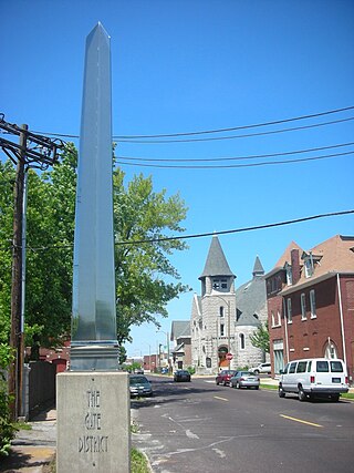
The Gate District is a neighborhood of St. Louis, Missouri. The Gate District is defined as the area between Chouteau Avenue and Interstate 44 on the north and south and between South Jefferson Avenue and South Grand Boulevard on the east and west. This area is just south of the central corridor and west of Lafayette Square. The term Gate was added to define this neighborhood due to the number of ironclad gates lining the streets. Today, the neighborhood is the subject of increased gentrification.

<span class="mw-page-title-main">Botanical Heights, St. Louis</span> Neighborhood of St. Louis in Missouri, United States

Botanical Heights is a neighborhood of St. Louis, Missouri. Its former name was McRee Town. The Botanical Heights neighborhood is defined by Chouteau Avenue on the North, Interstate 44 on the South, 39th Street on the East and Vandeventer Avenue on the West. This near Southside neighborhood is located just north of the Shaw neighborhood.

<span class="mw-page-title-main">Tiffany, St. Louis</span> Neighborhood of St. Louis in Missouri, United States

Tiffany is a neighborhood of St. Louis, Missouri. It is located on the western side of Grand Boulevard along the section containing St. Louis University's Medical Complex. The neighborhood is defined by Chouteau Avenue on the North, Interstate 44 on the South, Grand Boulevard on the East, and 39th Street on the West.

<span class="mw-page-title-main">Tower Grove South, St. Louis</span> Neighborhood of St. Louis in Missouri, United States

Tower Grove South is a neighborhood of south St. Louis, Missouri. Formerly known as Oak Hill, Tower Grove South is bounded by Arsenal Street on the north, Chippewa Street on the south, Kingshighway Boulevard on the west, and Grand Boulevard on the east. The majority of the neighborhood was built following the extension of streetcar lines from downtown St. Louis. Commercial development in the neighborhood is concentrated on Grand Boulevard in the east and Morganford Road in the west of the neighborhood. There are also scatterings of commercial and mixed use buildings on interior intersections.

The streets of St. Louis, Missouri, United States, and the surrounding area of Greater St. Louis are under the jurisdiction of the City of St. Louis Street Department. According to the Streets Division, there are 1,000-mile (1,600 km) of streets and 600-mile (970 km) of alleys within the city.

<span class="mw-page-title-main">The Grove, St. Louis</span>

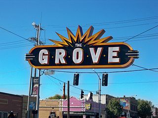
The Grove is a business district located along Manchester Avenue between Kingshighway Boulevard and Vandeventer Avenue in the Forest Park Southeast (FPSE) neighborhood of St. Louis, Missouri. Formerly known as the Manchester Strip, the retail drag was first developed in the late 19th century to serve the working-class population of Forest Park Southeast. Today, the Grove is home to a variety of restaurants, bars, and clubs, including a significant number of LGBT-oriented establishments. The district is supported by a community improvement district (CID), created in 2009, which levies an additional sales tax on businesses within its boundaries to fund infrastructure and branding services.

References

  1. "2020 Census Neighborhood Results".
  2. 1 2 3 4 5 6 7 8 9 10 11 "National Register of Historic Places Registration Form – Forest Park Southeast Historic District" (PDF). Missouri Department of Natural Resources. October 17, 2001.
  3. Suchland, Colin E. (August 2008). "The Sacred and the Urban: The Case for Social-Justice Gentrifiers" (PDF).
  4. 1 2 3 4 Suchland, Colin E. (2013). Culture, capital and community : gentrification and redevelopment in a St Louis neighborhood. MOspace (Thesis). University of Missouri Library Systems. doi:10.32469/10355/42985. hdl: 10355/42985 .
  5. "Park Central Development - Grove CID". Park Central Development. 2016.
  6. 1 2 3 Moore, Doug. "These longtime St. Louis residents are digging in as their neighborhood takes off". stltoday.com. Retrieved 2019-09-11.
  7. Barker, Jacob (December 1, 2017). "A Raising Cane's raises concerns in fast-growing, hip corner of St. Louis". St. Louis Post Dispatch. Retrieved 2019-09-11.
  8. "St. Louis: Forest Park Southeast Neighborhood Statistics".
  9. "City of St. Louis" (PDF). Retrieved 2021-09-15.
  10. "The City of St. Louis Missouri". City of St. Louis.
  11. "The City of St. Louis Missouri". City of St. Louis.

Sources

Coordinates: 38°37′33″N90°15′31″W / 38.6259°N 90.2585°W / 38.6259; -90.2585