Soulard is a historic neighborhood in St. Louis, Missouri. It is the home of Soulard Farmers Market, the oldest farmers' market west of the Mississippi River. Soulard is one of ten certified local historic districts in the city of St. Louis.

The Caves of St. Louis have been important in the economic development of St. Louis, Missouri, United States. The city was built upon a complex of natural caves which were once used for the lagering of beer by early German immigrant brewers. Caves are naturally cool, which was especially attractive to brewers before the advent of refrigeration.

Lafayette Square is a neighborhood in St. Louis, Missouri, which is bounded on the north by Chouteau Avenue, on the south by Interstate 44, on the east by Truman Parkway, and on the west by South Jefferson Avenue. It surrounds Lafayette Park, which is the city's oldest public park — created by local ordinance in 1836.

The Lemp Neighborhood Arts Center (LNAC), also known as "The Lemp," is a non-profit performance space, art gallery, and community center located in the historic Benton Park neighborhood of St. Louis, Missouri. Since its founding in March 1994, the organization has been among the forefront of art spaces committed to the DIY ethic in St. Louis and the Midwest, holding the position as one of the oldest all-ages "Do-It-Yourself" music venues in the region and in the United States, alongside ABC No Rio in New York City, 924 Gilman Street in Berkeley, California, and the Ché Café in La Jolla, California.

LaSalle Park is an integral part of the three-neighborhood "Old Frenchtown" area—LaSalle Park, Lafayette Square and Soulard—bordering the southern edge of downtown St. Louis. It was formed as a "new" neighborhood, legally distinct from the larger Soulard district, through the efforts of the city of St. Louis, Missouri and Ralston Purina, which has its world headquarters in LaSalle Park.
The Lemp Mansion is a historical house in Benton Park, St. Louis, Missouri. It is also the site of three suicides by Lemp family members after the death of the son Frederick Lemp, whose William J. Lemp Brewing Co. dominated the St. Louis beer market before Prohibition with its Falstaff beer brand. The mansion is said to be haunted by members of the Lemp family.

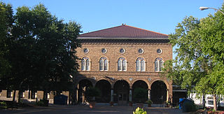
Shaw is a neighborhood in St. Louis, Missouri. It is bordered on the North by Interstate 44, the east by S. Grand Blvd, the west by Tower Grove Ave and the Missouri Botanical Gardens, and the south by Tower Grove Park. The Shaw Neighborhood is a local historic district whose historic structure and character is protected by ordinance.

Gus' Pretzels is a pretzel bakery and snack counter in the Benton Park neighborhood of St. Louis, Missouri, United States. It was opened in 1920 by Frank Ramsperger. Gus' is a third generation family business owned by the Koebbe family. It is located at 1820 Arsenal Street near the Anheuser-Busch brewery.
The Fred Krug Brewery was located at 2435 Deer Park Boulevard in Omaha, Nebraska. Founded in 1859, Krug Brewery was the first brewery in the city. Krug was one of the "Big 4" brewers located in Omaha, which also included the Storz, Willow Springs and Metz breweries. Later sold to Falstaff in 1936, the facility closed in 1987.

Benton Park West is a neighborhood located in South St. Louis City, Missouri, United States. The neighborhood is bounded by Jefferson Ave. on the east, Gravois Ave. on the north and west, and an irregular boundary consisting of Cherokee Street, S. Compton Ave., and Potomac St. to the south. The neighborhood is the conglomeration of two different neighborhoods in the 1970s, Compton Hill and Marquette-Cherokee. Parts of these two 1970s neighborhoods make up the current day Benton Park West. Marquette-Cherokee was bounded by Arsenal Street on the north, Bates Street on the south and Grand Boulevard on the west. Its eastern edge was the bank of the Mississippi River. Benton Park West has the highest percentage of Latino residents among St. Louis neighborhoods.

The Lemp Brewery was a beer brewing company established in 1840 in St. Louis, Missouri that was acquired by the Griesedieck Beverage Company in 1920, which subsequently became the Falstaff Brewing Corporation. The brewery complex property consists of 27 buildings on a 13.7-acre (0.055 km2) site in the Marine Villa neighborhood. St. Louisian Steve DeBellis has been the owner of the Lemp Brewing Company trademark since 1988.

The Falstaff Brewing Corporation was an American brewery located in St. Louis, Missouri. With roots in the 1838 Lemp Brewery of St. Louis, the company was renamed after the Shakespearean character Sir John Falstaff in 1903. Production peaked in 1965 with 7,010,218 barrels brewed and then dropped 70 percent in the next 10 years. While its smaller labels linger on today, its main label Falstaff Beer went out of production in 2005. The rights to the brand are owned by Pabst Brewing Company.

College Hill is a neighborhood of the City of St. Louis, Missouri. The name College Hill was given to this area because it was the location of the Saint Louis University College Farm. This area, bounded generally by Warne Ave., O'Fallon Park, I-70, Grand Boulevard, and W. Florissant Ave., was acquired by the University for garden and recreation purposes in 1836. It was subdivided in the early 1870s.

Fox Park is a neighborhood of St. Louis, Missouri. The neighborhood borders are Jefferson Avenue to the east, Interstate 44 to the north, Gravois Avenue to the south and Nebraska Avenue to the west. Surrounding neighborhoods include the Gate District, Compton Heights, Tower Grove East, Benton Park West and McKinley Heights.
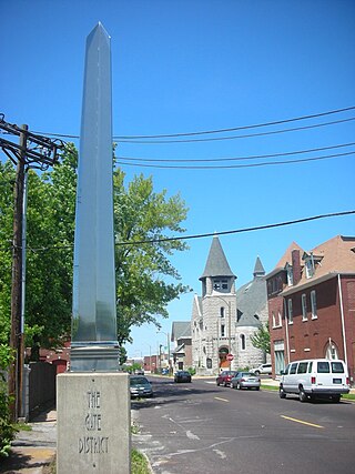
The Gate District is a neighborhood of St. Louis, Missouri. The Gate District is defined as the area between Chouteau Avenue and Interstate 44 on the north and south and between South Jefferson Avenue and South Grand Boulevard on the east and west. This area is just south of the central corridor and west of Lafayette Square. The term Gate was added to define this neighborhood due to the number of ironclad gates lining the streets. Today, the neighborhood is the subject of increased gentrification.
Marine Villa is a neighborhood of St. Louis, Missouri. The neighborhood is located just south of the large and historic Anheuser-Busch Brewery complex along the bluffs of the Mississippi River. It is further defined by Cherokee Street's Antique Row on the north, Gasconade Street on the south, South Broadway and Jefferson Avenue on the west, and the Mississippi River on the east.
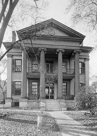
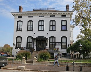
The Chatillon–DeMenil Mansion, located at 3352 DeMenil Place in Benton Park, St. Louis, Missouri, was begun in 1848 for the pioneer Henry Chatillon, then enlarged to its present form by prominent St. Louis businessman Nicolas DeMenil from 1855 to 1863. The house serves as a house museum, and according to its nomination to the National Register of Historic Places, described "as being the finest example of Greek Revival architecture in the Midwest."
The streets of St. Louis, Missouri, United States, and the surrounding area of Greater St. Louis are under the jurisdiction of the City of St. Louis Street Department. According to the department's Streets Division, there are 1,000 miles (1,600 km) of streets and 600 miles (970 km) of alleys within the city.
Cherokee Street is a culturally significant east-west street in South City, St. Louis, Missouri. Its western border is Grand Boulevard and its eastern border is Broadway.


