Southwest Garden, St. Louis

Last updated
Southwest Garden
Southwest Gardens.JPG
Southwest Garden Neighborhood sign at the corner of Shaw and Vandeventer Avenue, March 2011
STL Neighborhood Map 13.PNG
Location (red) of Southwest Garden within St. Louis
Country United States
State Missouri
City St. Louis
Wards 8, 10, 24
Area
  Total0.86 sq mi (2.2 km2)
Population
 (2020) [1]
  Total5,245
  Density6,100/sq mi (2,400/km2)
ZIP code(s)
Parts of 63110, 63139
Area code(s) 314
Website stlouis-mo.gov

Southwest Garden is a neighborhood of St. Louis, Missouri, located south of The Hill and Forest Park Southeast, west of the Missouri Botanical Garden and Tower Grove Park, east of Lindenwood Park and Clifton Heights, and north of North Hampton.

Contents

Bisected by Kingshighway Boulevard, one of St. Louis’s major arterial roads, Southwest Garden is named for its proximity to the Botanical Garden. The neighborhood is notable for its architectural heritage, containing two National Historic Landmark Districts:

1920s "American Movements"-style duplexes on Shenandoah Avenue in the Shaw's Garden National Historic Landmark District. Duplexes on Shenandoah Avenue in Southwest Garden, St. Louis.jpg
1920s “American Movements”-style duplexes on Shenandoah Avenue in the Shaw’s Garden National Historic Landmark District.

In addition to the Botanical Garden and Tower Grove Park, other notable locations within the neighborhood include:

The neighborhood is covered by St. Louis Board of Aldermen wards 8, 10 and 24.

History

Shaw’s Garden

In 1769, Illinois Country French settlers established the first European settlement in modern-day Southwest Garden with the creation of the Prairie des Noyers Commons, a large tract of agricultural land between Grand Avenue and Kingshighway Boulevard. In the 19th century, this communal land on the fringe of a growing St. Louis was gradually sold off to private landowners, including Henry Shaw. Shaw’s holdings came to encompass the modern-day Botanical Garden and most of the land between modern-day Tower Grove Park and Vandeventer Avenue. [2]

Inspired by the gardens of Chatsworth House in England, Shaw created the Missouri Botanical Garden, which opened in 1859, and bequeathed the land for Tower Grove Park to the City of St. Louis in 1868. This spurred the subdivision of several nearby tracts, including Tower Grove Place between Kingshighway and Alfred Avenue in 1870. The “Tower Grove Park Addition” was developed slowly over the following three decades due to poor access to the streetcar system; the nearest line was across Tower Grove Park on Arsenal Street. In 1897, the Missouri Street Railroad Company constructed a new streetcar line to Southampton extending down Vandeventer Avenue and Kingshighway, increasing the viability of residential development in the area. [2]

In the 1910s, under the direction of director George T. Moore and chief landscape architect John Noyes, the Botanical Garden began planning to subdivide its land holdings north and west of its modern boundaries, seeking to establish neighborhoods that would complement the Garden’s aesthetic. The first plat, the “Shaw’s Vandeventer Avenue Addition” north of the Garden (along present-day Interstate 44), was completed in 1916. The Garden generated substantial revenue from selling the land to developers, who constructed a variety of multi-family buildings over the following decade. [2]

The larger trapezoidal tract of land west of the Garden required more substantial planning. Following the subdivision planning principles of renowned landscape architect Henry Wright, Noyes designed a curved street grid that conformed to the tract’s irregular borders. The “Shaw’s Garden Subdivision” was fully developed by third-party builders by the end of the 1920s. [2]

Two private places, Gurney Court and Heger Court, were established by independent developers in the early 1920s along Magnolia Avenue, south of the “Tower Grove Park Addition” and north of Tower Grove Park. These small subdivisions each contain single-family homes centered around a landscaped court. [2]

West of Kingshighway

Southwest Garden west of Kingshighway has a history similar to its neighbor The Hill. After the "Great Fire" of 1848 destroyed large parts of St. Louis, an ordinance banning frame construction put a premium on brick construction. The demand for brick spurred the mining of clay deposits that had been found west of Kingshighway in the 1830s. As the mines attracted immigrant miners, they began to settle nearby areas. [7]

The establishment of St. Aloysius Gonzaga parish in 1892 helped further spur settlement. As a historically German parish, St. Aloysius Gonzaga represented and attracted more Germans. The parish was located at Magnolia and January Avenues. It was razed in 2006. [8]

Demographics

Historical population
CensusPop.Note
1990 5,203
2000 5,74810.5%
2010 4,885−15.0%
2020 5,2457.4%
Sources: [9] [10]

In 2020, Southwest Garden’s racial makeup was 73.8% White, 13.1% Black, 0.2% Native American, 4.7% Asian, 6.5% Two or More Races, and 1.8% Some Other Race. 4.5% of the people were of Hispanic or Latino origin. [11]

Related Research Articles

<span class="mw-page-title-main">Missouri Botanical Garden</span> Botanical garden in the United States

The Missouri Botanical Garden is a botanical garden located at 4344 Shaw Boulevard in St. Louis, Missouri. It is also known informally as Shaw's Garden for founder and philanthropist Henry Shaw. Its herbarium, with more than 6.6 million specimens, is the second largest in North America, behind that of the New York Botanical Garden. The Index Herbariorum code assigned to the herbarium is MO and it is used when citing housed specimens.

<span class="mw-page-title-main">Tower Grove Park</span> United States historic place

Tower Grove Park is a municipal park in St. Louis, Missouri. Located on the south side of the city, the elongated 289-acre (117 ha) park extends 1.6 miles (2.6 km) from Kingshighway Boulevard east to Grand Boulevard. The park’s predominately residential surroundings include the neighborhoods of Southwest Garden, Shaw, Tower Grove East, and Tower Grove South.

<span class="mw-page-title-main">Henry Shaw (philanthropist)</span> American philanthropist

Henry Shaw was a businessman, amateur botanist, and slave owner in St. Louis, MO when it was a gateway city to the West. His businesses supplied residents, pioneers and others. Having made his fortune, he was able to retire at age 40, pursue his interest in botany, and used much of his fortune in philanthropy. He is best known as the founder of the Missouri Botanical Garden, but he also donated the land to the city for Tower Grove Park and oversaw its development. He donated funds to several other city institutions as well.

<span class="mw-page-title-main">Shaw, St. Louis</span> Neighborhood of St. Louis in Missouri, United States

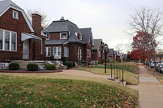
Shaw is a neighborhood in St. Louis, Missouri. It is bordered on the North by Interstate 44, the east by S. Grand Blvd, the west by Tower Grove Ave and the Missouri Botanical Gardens, and the south by Tower Grove Park. The Shaw Neighborhood is a local historic district whose historic structure and character is protected by ordinance.

<span class="mw-page-title-main">Southampton, St. Louis</span> Neighborhood of St. Louis in Missouri, United States

Southampton is a neighborhood in St. Louis, Missouri. Located in the southwestern reaches of the city, its borders are Chippewa Street on the north, Hampton Avenue on the west, Eichelberger Street on the south, and South Kingshighway Boulevard on the east.

<span class="mw-page-title-main">College Hill, St. Louis</span> Neighborhood of St. Louis in Missouri, United States

College Hill is a neighborhood of the City of St. Louis, Missouri. The name College Hill was given to this area because it was the location of the Saint Louis University College Farm. This area, bounded generally by Warne Ave., O'Fallon Park, I-70, Grand Boulevard, and W. Florissant Ave., was acquired by the University for garden and recreation purposes in 1836. It was subdivided in the early 1870s.

<span class="mw-page-title-main">Forest Park Southeast, St. Louis</span> Neighborhood of St. Louis in Missouri, United States

Forest Park Southeast (FPSE) is a neighborhood of St. Louis, Missouri. It is bordered by Interstate 64 (U.S. Route 40) to the north, Vandeventer Avenue to the east, Interstate 44 to the south, and Kingshighway Boulevard and Forest Park to the west. Adjoining neighborhoods include Kings Oak and The Hill to the west, Southwest Garden to the south, Botanical Heights to the southeast, Midtown to the east, and the Central West End to the north.

<span class="mw-page-title-main">JeffVanderLou, St. Louis</span> Neighborhood of St. Louis in Missouri, United States

JeffVanderLou (JVL) is a neighborhood of St. Louis, Missouri. The neighborhood is situated between North Vandeventer Avenue on the northwest, Natural Bridge Avenue on the northeast, North Jefferson Avenue on the East, Delmar Boulevard on the south, and North Compton Avenue and Martin Luther King Drive on the Southwest.

<span class="mw-page-title-main">Botanical Heights, St. Louis</span> Neighborhood of St. Louis in Missouri, United States

Botanical Heights is a neighborhood of St. Louis, Missouri. Its former name was McRee Town. The Botanical Heights neighborhood is defined by Chouteau Avenue on the North, Interstate 44 on the South, 39th Street on the East and Vandeventer Avenue on the West. This near Southside neighborhood is located just north of the Shaw neighborhood.

<span class="mw-page-title-main">Lindenwood Park, St. Louis</span> Neighborhood of St. Louis in Missouri, United States

Lindenwood Park is a neighborhood of St. Louis, Missouri. The Lindenwood Neighborhood is defined by Arsenal Street and I-44 to the north, Watson and Chippewa Street to the south, Hampton Avenue on the east and the city limits to the west.

<span class="mw-page-title-main">North Hampton, St. Louis</span> Neighborhood of St. Louis in Missouri, United States

North Hampton is a neighborhood of St. Louis, Missouri. Located in Southwest City, North Hampton is bounded by Scanlan and Connecticut to the north, South Kingshighway Boulevard to the east, Chippewa Street to the south, and Hampton Avenue to the west.

<span class="mw-page-title-main">Penrose, St. Louis</span> Neighborhood of St. Louis in Missouri, United States

Penrose is a neighborhood of St. Louis, Missouri. The Penrose neighborhood is split with half of it in the city's 21st Ward and the other half in the city's 1st Ward. The neighborhood is located on the north side of the city just south of Interstate 70 and west of O’Fallon Park. It is bounded by Florissant Avenue and I-70 on the north, Natural Bridge on the south, North Newstead and Pope Avenue on the east, and Kingshighway Boulevard on the west.

<span class="mw-page-title-main">Princeton Heights, St. Louis</span> Neighborhood of St. Louis in Missouri, United States

Princeton Heights is a neighborhood of St. Louis, Missouri. The neighborhood boundaries are defined as Hampton Boulevard on the west, Eichelberger on the north, Christy Boulevard on the east, and Gravois on the south.

<span class="mw-page-title-main">Tiffany, St. Louis</span> Neighborhood of St. Louis in Missouri, United States

Tiffany is a neighborhood of St. Louis, Missouri. It is located on the western side of Grand Boulevard along the section containing St. Louis University's Medical Complex. The neighborhood is defined by Chouteau Avenue on the North, Interstate 44 on the South, Grand Boulevard on the East, and 39th Street on the West.

<span class="mw-page-title-main">Tower Grove East, St. Louis</span> Neighborhood of St. Louis in Missouri, United States

Tower Grove East is a neighborhood of St. Louis, Missouri. The Tower Grove East neighborhood is bordered by Shenandoah Avenue to the north, Nebraska Avenue to the east, Gravois Avenue to the south, and south Grand Boulevard to the west.

<span class="mw-page-title-main">Tower Grove South, St. Louis</span> Neighborhood of St. Louis in Missouri, United States

Tower Grove South is a neighborhood of south St. Louis, Missouri. Formerly known as Oak Hill, Tower Grove South is bounded by Arsenal Street on the north, Chippewa Street on the south, Kingshighway Boulevard on the west, and Grand Boulevard on the east. The majority of the neighborhood was built following the extension of streetcar lines from downtown St. Louis. Commercial development in the neighborhood is concentrated on Grand Boulevard in the east and Morganford Road in the west of the neighborhood. There are also scatterings of commercial and mixed use buildings on interior intersections.

<span class="mw-page-title-main">Vandeventer, St. Louis</span> Neighborhood of St. Louis in Missouri, United States

Vandeventer is a neighborhood of St. Louis, Missouri. The area is bounded by Dr. Martin Luther King Drive on the North, Delmar Boulevard on the South, Vandeventer Avenue on the East, and Newstead Avenue on the West.

The streets of St. Louis, Missouri, United States, and the surrounding area of Greater St. Louis are under the jurisdiction of the City of St. Louis Street Department. According to the Streets Division, there are 1,000-mile (1,600 km) of streets and 600-mile (970 km) of alleys within the city.

<span class="mw-page-title-main">The Grove, St. Louis</span>

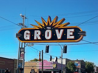
The Grove is a business district located along Manchester Avenue between Kingshighway Boulevard and Vandeventer Avenue in the Forest Park Southeast (FPSE) neighborhood of St. Louis, Missouri. Formerly known as the Manchester Strip, the retail drag was first developed in the late 19th century to serve the working-class population of Forest Park Southeast. Today, the Grove is home to a variety of restaurants, bars, and clubs, including a significant number of LGBT-oriented establishments. The district is supported by a community improvement district (CID), created in 2009, which levies an additional sales tax on businesses within its boundaries to fund infrastructure and branding services.

The Transgender Memorial Garden is a memorial to transgender people killed by anti-LGBTQ violence. It is located at 2800 Wyoming Street in the Benton Park West neighborhood of St. Louis, Missouri.

References

  1. 2020 Census Neighborhood Results
  2. 1 2 3 4 5 6 "National Register of Historic Places Registration Form – Shaw's Garden Historic District" (PDF). Missouri State Parks. 2012-02-12. pp. 174–184. Retrieved 2023-02-19.
  3. "National Register of Historic Places Registration Form – Reber Place" (PDF). Missouri State Parks. 2012-01-20. Retrieved 2023-02-19.
  4. "St. Louis Psychiatric Rehabilitation Center". University of Missouri–St. Louis – St. Louis Psychology Internship Consortium. Retrieved 2023-02-19.
  5. 1 2 Schremp Hahn, Valerie (2019-04-14). "150 years: From Lunatic Asylum to St. Louis Psychiatric Rehabilitation Center". St. Louis Post-Dispatch . pp. B1.
  6. "Women in Health Sciences". Washington University in St. Louis School of Medicine. 2009. Retrieved 2023-02-19.
  7. "SWGNA".
  8. http://www.southwestgarden.org/?page_id=6
  9. "Southwest Garden Neighborhood Statistics". St Louis, MO. Retrieved 26 January 2023.
  10. "Neighborhood Census Data". City of St. Louis. Retrieved 26 January 2023.
  11. https://www.stlouis-mo.gov/government/departments/planning/research/documents/upload/Total-Population-by-Neighborhood-Census-2020-Redistricting-Release-2.pdf [ bare URL PDF ]

38°36′28″N90°16′25″W / 38.6078°N 90.2735°W / 38.6078; -90.2735