The Central West End is a neighborhood in St. Louis, Missouri, stretching from Midtown's western edge to Union Boulevard and bordering on Forest Park with its outstanding array of free cultural institutions. It includes the Cathedral Basilica of Saint Louis on Lindell Boulevard at Newstead Avenue, which houses the largest collection of mosaics in the world. The Central West End sits entirely within the 9th Ward.
Swan Lake is a historic district in Tulsa, Oklahoma. Its borders consist of 15th Street to the North, Utica Street to the East, 21st Street to the South, and Peoria Avenue to the west. The District was developed in the early 20th century as a middle-class residential area with single-family homes, some duplexes and apartment buildings. It is still considered a highly regarded residential area with a high occupancy rate.

Waddy Butler Wood was a prominent American architect of the early 20th century and resident of Washington, D.C. Although Wood designed and remodeled numerous private residences, his reputation rested primarily on his larger commissions, such as banks, commercial offices, and government buildings. His most famous works include the Woodrow Wilson House and the Main Interior Building.

Sugar Hill is a National Historic District in the Harlem and Hamilton Heights neighborhoods of Manhattan, New York City, bounded by West 155th Street to the north, West 145th Street to the south, Edgecombe Avenue to the east, and Amsterdam Avenue to the west. The equivalent New York City Historic Districts are:

Annie Minerva Turnbo Malone was an American businesswoman, inventor and philanthropist. In the first three decades of the 20th century, she founded and developed a large and prominent commercial and educational enterprise centered on cosmetics for African-American women.
Samuel M. Plato (1882–1957) was an American architect and building contractor who is noted for his work on federal housing projects and U.S. post offices, as well as designing and building other structures in the United States such as private homes, banks, churches, and schools. During World War II, the Alabama native was one of the few African-American contractors in the country to be awarded wartime building contracts, which included Wake and Midway Halls. He also received contracts to build at least thirty-eight U.S. post offices across the country.

Sumner High School, also known as Sumner Stone High School, is a St. Louis public high school that was the first high school for African-American students west of the Mississippi River in the United States. Together with Vashon High School, Sumner was one of only two public high schools in St. Louis City for African-American students and was segregated. Established in 1875 only after extensive lobbying by some of St. Louis' African-American residents, Sumner moved to its current location in 1908.
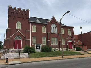
The Antioch Baptist Church in St. Louis, Missouri is a church long important in the black community of the Ville neighborhood of North St. Louis. It is located in a Gothic Revival-style brick building at 4213 N. Market St. which was built in 1921. The building was added to the National Register of Historic Places in 1999.

William Butts Ittner was an architect in St. Louis, Missouri. He designed over 430 school buildings in Missouri and other areas, was president of the St. Louis Chapter of the American Institute of Architects from 1893 to 1895, was awarded an honorary degree by the University of Missouri in 1930, served as president of the Architectural League of America during 1903–04, and at the time of his death was president of the St. Louis Plaza Commission, a fellow and life member of the American Institute of Architects, and a thirty-third degree Mason. He was described as the most influential man in school architecture in the United States and has a star on the St. Louis Walk of Fame. He was appointed St. Louis School Board commissioner in 1897 and is said to have designed open buildings that featured "natural lighting, inviting exteriors, and classrooms tailored to specific needs." In 1936, Ittner died. His legacy is survived by the William B. Ittner, Inc. and Ittner & Bowersox, Inc. architecture firms in St. Louis.
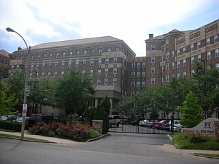
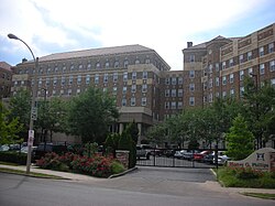
Homer G. Phillips Hospital was the only public hospital for African Americans in St. Louis, Missouri from 1937 until 1955, when the city began to desegregate. It continued to operate after the desegregation of city hospitals, and continued to serve the Black community of St. Louis until its closure in 1979.

Harris–Stowe State University (HSSU) is a public historically black university in St. Louis, Missouri. The university offers 50 majors, minors, and certificate programs in education, business, and arts & sciences. It is a member-school of the Thurgood Marshall College Fund. It is immediately east of the Saint Louis University campus. The school enrolled 1,084 students in 2022.
McKissack & McKissack is an American design, program management and construction firm based in New York. It is the oldest Black-owned architecture and construction company in the United States.
This is a list of properties and historic districts within the Downtown St. Louis and Downtown West, St. Louis areas of the city of St. Louis, Missouri that are listed on the National Register of Historic Places. The downtown area is defined by Cole Street to the north, the river front to the east, Chouteau Avenue to the south, and Jefferson Avenue to the west. Tucker Avenue divides Downtown to the east from Downtown West to the west.

Charles Sumner Sedgwick was an American architect based in Minneapolis, Minnesota.
Herman H. Dreer (1888–1981) was an American academic administrator, educator, educational reformer, activist, author, editor, Baptist minister, and civil rights leader. He is best known for writing curriculum and programming for teaching African American History at most grade levels for early 20th-century public schools. Dreer is also credited with initiating Black History Month observance in the United States, alongside Carter G. Woodson.
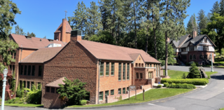
The Marycliff-Cliff Park Historic District is a historic residential area in the Cliff/Cannon neighborhood of Spokane, Washington, located immediately uphill from the city's downtown core, listed on the National Register of Historic Places (NRHP). The district is made up of two distinct but connected areas, the Marycliff section located at the base of a basalt cliff and south of Seventh Avenue, and the Cliff Park section located atop the cliff and north of 14th Avenue. Encroachment from the nearby city center has changed the nature of the Marycliff section over the decades. Of the palatial homes built in the late 1800s in the area, all have either been converted to commercial or public use or razed to make way for new development, though there are still a number of properties that are intact and reflect the historic nature of the area. The Cliff Park section retains its original residential character and historic nature, with only 11 properties listed as intrusive among the 118 properties in the area.
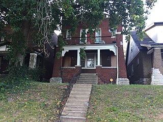
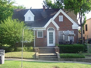
The Dr. Herman S. Dreer House is a historic building built in 1930 and located at 4335 Cote Brilliante Avenue in the The Ville neighborhood of St. Louis, Missouri.
Edwards Heights Historic District is a U.S. historic district and residential neighborhood in Oklahoma City, Oklahoma. It is approximately 4 miles east of downtown Oklahoma City and is roughly bounded by NE. 16th Street, N. Page Avenue, NE. Success Street and N. Bryant Avenue, extension on NE. Grand Boulevard. The Edward Heights Historic District was developed and subdivided specifically for African-Americans; and was founded in the 1930s and 1940s, at a time of racist residential deed restrictions in Oklahoma City.
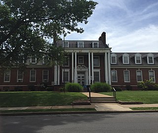
St. Louis Colored Orphans Home is a historic orphanage for Black orphans and building in The Ville neighborhood of St. Louis, Missouri, U.S.. It is known as the Annie Malone Children and Family Service Center since 1946. It serves as a shelter for children who need a temporary home and a counseling center for families in crisis. The St. Louis Colored Orphans Home has been listed on the National Register of Historic Places since 1999, for the architecture and contributions to Black history.

Simmons Colored School is a historic building and a former African American school in The Ville neighborhood of St. Louis, Missouri, U.S.. It served as a historically segregated African American elementary school and middle school from 1898 until 1930. The building served as the Stowe Teachers College campus, an African American normal school and junior college from 1930 until 1940. The building has played an important role in The Ville community since its inception. The school was also known as Elleardsville School for Colored Children No. 8, Colored School #8, Simmons Middle School, and Simmons School.