Anheuser-Busch Companies, LLC, is an American brewing company headquartered in St. Louis, Missouri. Since 2008, it has been wholly owned by Anheuser-Busch InBev SA/NV, now the world's largest brewing company, which owns multiple global brands, notably Budweiser, Michelob, Stella Artois, and Beck's.

Adolphus Busch was the German-born co-founder of Anheuser-Busch with his father-in-law, Eberhard Anheuser. He introduced numerous innovations, building the success of the company in the late 19th and early 20th centuries. He became a philanthropist, using some of his wealth for education and humanitarian needs. His great-great-grandson, August Busch IV, is a former CEO of Anheuser-Busch.
Soulard is a historic neighborhood in St. Louis, Missouri. It is the home of Soulard Farmers Market, the oldest farmers' market west of the Mississippi River. Soulard is one of ten certified local historic districts in the city of St. Louis.

The Caves of St. Louis have been important in the economic development of St. Louis, Missouri, United States. The city was built upon a complex of natural caves which were once used for the lagering of beer by early German immigrant brewers. Caves are naturally cool, which was especially attractive to brewers before the advent of refrigeration.

LaSalle Park is an integral part of the three-neighborhood "Old Frenchtown" area—LaSalle Park, Lafayette Square and Soulard—bordering the southern edge of downtown St. Louis. It was formed as a "new" neighborhood, legally distinct from the larger Soulard district, through the efforts of the city of St. Louis, Missouri and Ralston Purina, which has its world headquarters in LaSalle Park.
Columbus, the state capital and Ohio's largest city, has numerous neighborhoods within its city limits. Neighborhood names and boundaries are not officially defined. They may vary or change from time to time due to demographic and economic variables.
The Fred Krug Brewery was located at 2435 Deer Park Boulevard in Omaha, Nebraska. Founded in 1859, Krug Brewery was the first brewery in the city. Krug was one of the "Big 4" brewers located in Omaha, which also included the Storz, Willow Springs and Metz breweries. Later sold to Falstaff in 1936, the facility closed in 1987.

Benton Park West is a neighborhood located in South St. Louis City, Missouri, United States. The neighborhood is bounded by Jefferson Ave. on the east, Gravois Ave. on the north and west, and an irregular boundary consisting of Cherokee Street, S. Compton Ave., and Potomac St. to the south. The neighborhood is the conglomeration of two different neighborhoods in the 1970s, Compton Hill and Marquette-Cherokee. Parts of these two 1970s neighborhoods make up the current day Benton Park West. Marquette-Cherokee was bounded by Arsenal Street on the north, Bates Street on the south and Grand Boulevard on the west. Its eastern edge was the bank of the Mississippi River. Benton Park West has the highest percentage of Latino residents among St. Louis neighborhoods.

The Lemp Brewery was a beer brewing company established in 1840 in St. Louis, Missouri that was acquired by the Griesedieck Beverage Company in 1920, which subsequently became the Falstaff Brewing Corporation. The brewery complex property consists of 27 buildings on a 13.7-acre (0.055 km2) site in the Marine Villa neighborhood. St. Louisian Steve DeBellis has been the owner of the Lemp Brewing Company trademark since 1988.

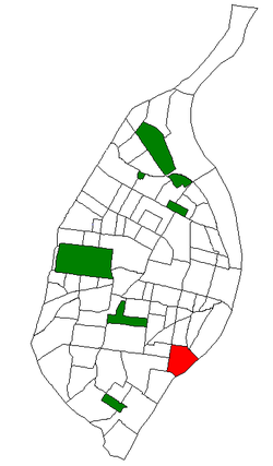
Benton Park is a neighborhood in southside St. Louis, Missouri, just west of the Soulard neighborhood. The official boundaries of the area are Gravois Avenue on the north, Cherokee Street on the south, I-55 on the east, and Jefferson Avenue on the west. Benton Park is unrelated to Benton Place, a private street located in Lafayette Square, St. Louis.

Anheuser-Busch Brewery is a brewery complex in St. Louis, Missouri. It was opened in 1852 by German immigrant Adolphus Busch. It a National Historic Landmark District. The Lyon Schoolhouse Museum is on the grounds at the Anheuser-Busch Brewery. It is considered to be one of oldest school buildings in St Louis. It served as the head offices of the brewery after 1907. The museum contains rare mementos gathered from the founding of the company to current day, including pictures of the brewery and its expansion over the years. The 142 acres (57 ha) property includes 189 buildings. Some of the most striking are red brick Romanesque architecture with crenelated towers and elaborate ornamentation.
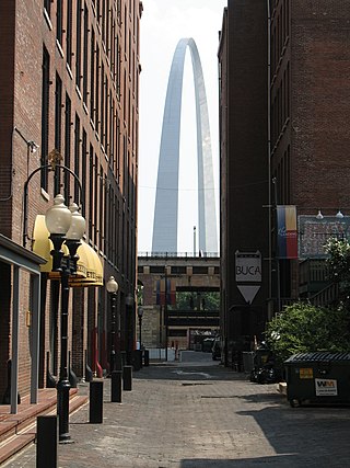
The architecture of St. Louis exhibits a variety of commercial, residential, and monumental architecture. St. Louis, Missouri is known for the Gateway Arch, the tallest monument constructed in the United States. Architectural influences reflected in the area include French Colonial, German, early American, European influenced, French Second Empire, Victorian, and modern architectural styles.
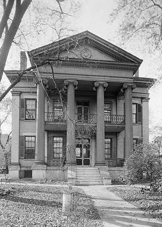
The Chatillon–DeMenil Mansion, located at 3352 DeMenil Place in Benton Park, St. Louis, Missouri, was begun in 1848 for the pioneer Henry Chatillon, then enlarged to its present form by prominent St. Louis businessman Nicolas DeMenil from 1855 to 1863. The house serves as a house museum, and according to its nomination to the National Register of Historic Places, described "as being the finest example of Greek Revival architecture in the Midwest."
The streets of St. Louis, Missouri, United States, and the surrounding area of Greater St. Louis are under the jurisdiction of the City of St. Louis Street Department. According to the department's Streets Division, there are 1,000 miles (1,600 km) of streets and 600 miles (970 km) of alleys within the city.
Jefferson Avenue is a major, seven lane wide, north to south thoroughfare in the city of St. Louis, Missouri. For much of its run in south city Jefferson Avenue and Grand Boulevard take a parallel course, separated by about sixteen blocks. In the northern city, their concurrence varies some.
The history of St. Louis, Missouri, from 1866 to 1904 was marked by rapid growth. Its population increased, making it the country's fourth-largest city after New York City, Philadelphia, and Chicago. It also saw rapid development of heavy industry, infrastructure, and transportation. The period culminated with the city's hosting of the 1904 World's Fair and 1904 Summer Olympics.
Cherokee Street is a culturally significant east-west street in South City, St. Louis, Missouri. Its western border is Grand Boulevard and its eastern border is Broadway.

The Marine Villa Neighborhood Historic District is a residential historic district in the Marine Villa neighborhood of St. Louis, Missouri, United States. The district encompasses ten blocks and includes 356 buildings and sites, 187 of which are considered contributing resources to the district's historic character. Construction in the area began in 1870, but poor infrastructure and street access limited settlement. A streetcar line opened on South Broadway in 1890, leading the district to develop into one of St. Louis' many streetcar suburbs of the era. Most of the neighborhood's early residents were working-class and middle-class German immigrants and their families. The district's buildings are mainly one- and two-story brick buildings, and as the majority were built by individual property owners, they feature a wide variety of styles and shapes; the architectural styles used in the district include Spanish Colonial Revival, Romanesque Revival, Colonial Revival, Tudor Revival, Italianate, and Second Empire.