
Clifton Heights is a neighborhood of St. Louis, Missouri, US, located along the southwest border of the city and highlighted by a park — Clifton Park (38.6143°N 90.2916°W) — with a playground and a lake.

North Point is a neighborhood of St. Louis, Missouri, US. It is bounded by Goodfellow on the North, Northcrest, West Florissant on the Southwest, and Riverview Boulevard on the East and Northeast.
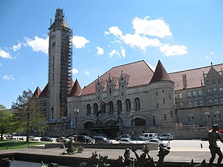
Downtown West is a neighborhood in St. Louis, Missouri. It is, as the name suggests, a section of downtown that is further inland, west from the banks of the Mississippi River. St. Louis City Hall, the Metropolitan Police Headquarters, St. Louis Union Station, Stifel Theatre, Enterprise Center, and CityPark stadium are all located in Downtown West. The Washington Avenue Historic District is a former garment district consisting of turn of the previous century high rise warehouses converted into residential lofts, restaurants, taverns, and coffee shops. It is bounded by Jefferson Avenue on the west, Tucker Boulevard on the east, Cole Street on the north, and Chouteau Avenue on the south.
Fairground is a neighborhood of St. Louis, Missouri. The neighborhood's boundaries are defined as Glasgow Avenue on the east, west and North Florissant Avenues on the north, Warne on the west, and Fairground Park and Natural Bridge Avenue on the south.

Forest Park Southeast (FPSE) is a neighborhood of St. Louis, Missouri. It is bordered by Interstate 64 (U.S. Route 40) to the north, Vandeventer Avenue to the east, Interstate 44 to the south, and Kingshighway Boulevard and Forest Park to the west. Adjoining neighborhoods include Kings Oak and The Hill to the west, Southwest Garden to the south, Botanical Heights to the southeast, Midtown to the east, and the Central West End to the north.

Fountain Park is a neighborhood of St. Louis, Missouri, United States. Originally the Aubert Place subdivision, it was laid out by John Lay in 1857. The Fountain Park neighborhood is located in north St. Louis with Martin Luther King Drive on the north, Delmar Boulevard on the south, Walton Avenue on the east, and Kingshighway Boulevard on the west. It is just two blocks north of the Central West End (CWE) of the city. The Fountain Park neighborhood is named after Fountain Park, a small oval-shaped city park near its center. A Martin Luther King Jr. statue sculpted by Rudolph Edward Torrini is situated on the west side of the park.

Fox Park is a neighborhood of St. Louis, Missouri. The neighborhood borders are Jefferson Avenue to the east, Interstate 44 to the north, Gravois Avenue to the south and Nebraska Avenue to the west. Surrounding neighborhoods include the Gate District, Compton Heights, Tower Grove East, Benton Park West and McKinley Heights.

The Greater Ville is a neighborhood of St. Louis, Missouri. The area is bounded by Marcus Avenue on the northwest, Natural Bridge Avenue on the northeast, Dr. Martin Luther King Drive and St. Louis Avenue on the south via North Taylor Avenue and Sarah Street, and North Vandeventer Avenue on the southeast. The Greater Ville surrounds The Ville neighborhood.

Hamilton Heights is a neighborhood of St. Louis, Missouri. The neighborhood is bounded by Dr. Martin Luther King Drive on the Northeast, the city limits on the Northwest, Page Avenue on the South, and Union Boulevard on the East.

Holly Hills is a neighborhood located in South St. Louis, Missouri, near the intersection of I-55 and Loughborough Avenue. The neighborhood is defined by Bates and Walsh on the Northeast, Holly Hills on the Southwest, Morganford St on the Northwest, and Grand Boulevard on the Southeast. It is surrounded by Carondelet Park and the Boulevard Heights, Bevo Mill, Dutchtown and Carondelet neighborhoods.

Hyde Park is a neighborhood of St. Louis, Missouri. A historic North St. Louis neighborhood, Hyde Park is bound by Ferry to the North, I-70 to the East, Palm Street and Natural Bridge Avenue to the South, and Glasgow to the West.

Mark Twain/I-70 Industrial is a neighborhood of St. Louis, Missouri. It is bound by I-70 to the north, North Kingshighway to the east, Natural Bridge Road to the south, and the city limit to the west.

North Hampton is a neighborhood of St. Louis, Missouri. Located in Southwest City, North Hampton is bounded by Scanlan and Connecticut to the north, South Kingshighway Boulevard to the east, Chippewa Street to the south, and Hampton Avenue to the west.

North Riverfront is a neighborhood of St. Louis, Missouri. The neighborhood is bounded by Adelaide St. on the south, the Mississippi River on the east, Maline Creek on the north, and Hall Street, Calvary Avenue, Bellefontaine Cemetery, and I-70 to the west.

O'Fallon is a neighborhood of St. Louis, Missouri. The neighborhood is located on the north side of the City of St. Louis, nestled between O'Fallon Park and Fairground Park. It is bounded by West Florissant, Harris Avenue, Algernon Street and Adelaide on the north, Pope Avenue on the northwest, Kossuth and Natural Bridge Avenues on the south via Fair Avenue, Warne on the east, and Newstead on the west. The O'Fallon neighborhood is located in the 21st Ward which is currently represented by Alderman John Collins-Muhammad.

Riverview is a neighborhood of St. Louis, Missouri. Riverview comprises the extreme northern section of the city, bounded by the Mississippi River to the east, the city limits to the west, and Chain of Rocks Road to the south, with the northern boundary lying a third of a mile north of I-270. The only major road running through the neighborhood is Riverview Drive.

Tower Grove South is a neighborhood of south St. Louis, Missouri. Formerly known as Oak Hill, Tower Grove South is bounded by Arsenal Street on the north, Chippewa Street on the south, Kingshighway Boulevard on the west, and Grand Boulevard on the east. The majority of the neighborhood was built following the extension of streetcar lines from downtown St. Louis. Commercial development in the neighborhood is concentrated on Grand Boulevard in the east and Morganford Road in the west of the neighborhood. There are also scatterings of commercial and mixed use buildings on interior intersections.

Visitation Park is a neighborhood in St. Louis, Missouri. The neighborhood is defined by Maple Avenue on the North, Delmar Boulevard on the South, Union Boulevard on the East, and Belt Avenue on the West. Visitation Park is a small neighborhood nestled southeast of the West End neighborhood, just north of DeBaliviere Place.

Walnut Park East is a neighborhood of St. Louis, Missouri. Walnut Park East is one of several neighborhoods in northwest St. Louis. Its borders are West Florissant Avenue to the northeast, Emerson Avenue to the southeast, Interstate 70 (I-70) to the southwest and west, and Riverview Boulevard to the northwest.

West End is a neighborhood of St. Louis, Missouri. This neighborhood is defined by Page Boulevard on the North, Delmar Boulevard on the South, Belt Avenue and Union Boulevard via Maple Avenue on the East, and City limits on the West. The neighborhood is home to the Emmanuel DeHodiamont House, one of the two oldest houses in St. Louis.

