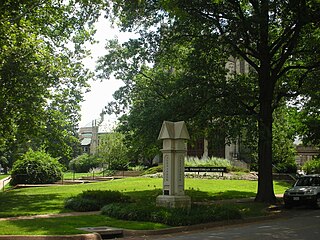
The Central West End is a neighborhood in St. Louis, Missouri, stretching from Midtown's western edge to Union Boulevard and bordering on Forest Park with its outstanding array of free cultural institutions. It includes the Cathedral Basilica of Saint Louis on Lindell Boulevard at Newstead Avenue, which houses the largest collection of mosaics in the world. The Central West End sits entirely within the 9th Ward.

Lafayette Square is a neighborhood in St. Louis, Missouri, which is bounded on the north by Chouteau Avenue, on the south by Interstate 44, on the east by Truman Parkway, and on the west by South Jefferson Avenue. It surrounds Lafayette Park, which is the city's oldest public park — created by local ordinance in 1836.

Shaw is a neighborhood in St. Louis, Missouri. It is bordered on the North by Interstate 44, the east by S. Grand Blvd, the west by Tower Grove Ave and the Missouri Botanical Gardens, and the south by Tower Grove Park. The Shaw Neighborhood is a local historic district whose historic structure and character is protected by ordinance.
Wydown/Skinker is a neighborhood in St. Louis, Missouri. Washington University in St. Louis is located just north of this neighborhood. The neighborhood is bounded by the city limits on the west, Forsyth Boulevard on the north, Forest Park on the east and Clayton Avenue on the south. The Missouri Historical Society Library & Research Center is located in the Wydown/Skinker neighborhood.

College Hill is a neighborhood of the City of St. Louis, Missouri. The name College Hill was given to this area because it was the location of the Saint Louis University College Farm. This area, bounded generally by Warne Ave., O'Fallon Park, I-70, Grand Boulevard, and W. Florissant Ave., was acquired by the University for garden and recreation purposes in 1836. It was subdivided in the early 1870s.

DeBaliviere Place is a neighborhood of St. Louis, Missouri.
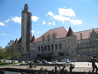
Downtown West is a neighborhood in St. Louis, Missouri. It is, as the name suggests, a section of downtown that is further inland, west from the banks of the Mississippi River. St. Louis City Hall, the Metropolitan Police Headquarters, St. Louis Union Station, Stifel Theatre, Enterprise Center, and CityPark stadium are all located in Downtown West. The Washington Avenue Historic District is a former garment district consisting of turn of the previous century high rise warehouses converted into residential lofts, restaurants, taverns, and coffee shops. It is bounded by Jefferson Avenue on the west, Tucker Boulevard on the east, Cole Street on the north, and Chouteau Avenue on the south.
Fairground is a neighborhood of St. Louis, Missouri. The neighborhood's boundaries are defined as Glasgow Avenue on the east, west and North Florissant Avenues on the north, Warne on the west, and Fairground Park and Natural Bridge Avenue on the south.

Forest Park Southeast (FPSE) is a neighborhood of St. Louis, Missouri. It is bordered by Interstate 64 (U.S. Route 40) to the north, Vandeventer Avenue to the east, Interstate 44 to the south, and Kingshighway Boulevard and Forest Park to the west. Adjoining neighborhoods include Kings Oak and The Hill to the west, Southwest Garden to the south, Botanical Heights to the southeast, Midtown to the east, and the Central West End to the north.

Fountain Park is a neighborhood of St. Louis, Missouri, United States. Originally the Aubert Place subdivision, it was laid out by John Lay in 1857. The Fountain Park neighborhood is located in north St. Louis with Martin Luther King Drive on the north, Delmar Boulevard on the south, Walton Avenue on the east, and Kingshighway Boulevard on the west. It is just two blocks north of the Central West End (CWE) of the city. The Fountain Park neighborhood is named after Fountain Park, a small oval-shaped city park near its center. A Martin Luther King Jr. statue sculpted by Rudolph Edward Torrini is situated on the west side of the park.

Fox Park is a neighborhood of St. Louis, Missouri. The neighborhood borders are Jefferson Avenue to the east, Interstate 44 to the north, Gravois Avenue to the south and Nebraska Avenue to the west. Surrounding neighborhoods include the Gate District, Compton Heights, Tower Grove East, Benton Park West and McKinley Heights.
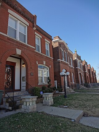
The Gate District is a neighborhood of St. Louis, Missouri. The Gate District is defined as the area between Chouteau Avenue and Interstate 44 on the north and south and between South Jefferson Avenue and South Grand Boulevard on the east and west. This area is just south of the central corridor and west of Lafayette Square. The term Gate was added to define this neighborhood due to the number of ironclad gates lining the streets. Today, the neighborhood is the subject of increased gentrification.

The Greater Ville is a neighborhood of St. Louis, Missouri. The area is bounded by Marcus Avenue on the northwest, Natural Bridge Avenue on the northeast, Dr. Martin Luther King Drive and St. Louis Avenue on the south via North Taylor Avenue and Sarah Street, and North Vandeventer Avenue on the southeast. The Greater Ville surrounds The Ville neighborhood.

Hyde Park is a neighborhood of St. Louis, Missouri. A historic North St. Louis neighborhood, Hyde Park is bound by Ferry to the North, I-70 to the East, Palm Street and Natural Bridge Avenue to the South, and Glasgow to the West.

JeffVanderLou (JVL) is a neighborhood of St. Louis, Missouri. The neighborhood is situated between North Vandeventer Avenue on the northwest, Natural Bridge Avenue on the northeast, North Jefferson Avenue on the East, Delmar Boulevard on the south, and North Compton Avenue and Martin Luther King Drive on the Southwest.

Lewis Place is a neighborhood of St. Louis, Missouri. Lewis Place is defined by Martin Luther King Drive on the North, Delmar Boulevard on the South, Newstead Avenue on the East, and Walton on the West.

Botanical Heights is a neighborhood of St. Louis, Missouri. Its former name was McRee Town. The Botanical Heights neighborhood is defined by Chouteau Avenue on the North, Interstate 44 on the South, 39th Street on the East and Vandeventer Avenue on the West. This near Southside neighborhood is located just north of the Shaw neighborhood.

Southwest Garden is a neighborhood of St. Louis, Missouri, located south of The Hill and Forest Park Southeast, west of the Missouri Botanical Garden and Tower Grove Park, east of Lindenwood Park and Clifton Heights, and north of North Hampton.

Penrose is a neighborhood of St. Louis, Missouri. The neighborhood is located on the north side of the city just south of Interstate 70 and west of O’Fallon Park. It is bounded by Florissant Avenue and I-70 on the north, Natural Bridge on the south, North Newstead and Pope Avenue on the east, and Kingshighway Boulevard on the west.
Delmar Boulevard is a major east-west street in St. Louis, Missouri, United States.