List of neighborhoods of St. Louis

Last updated

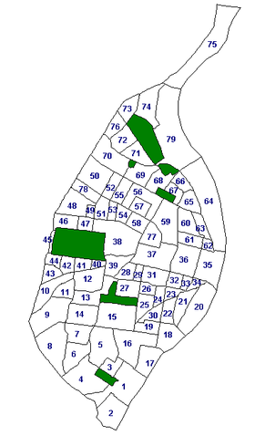
The City of St. Louis officially recognizes 79 neighborhoods within its limits. [1] Census data is collected for each neighborhood, as well as crime data, historic property data, and dining establishment health ratings. National historic neighborhoods are identified by the official neighborhood to which they belong.

Contents

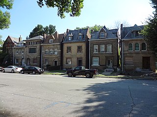
Also, several neighborhood names extend to areas well beyond their technical borders. For example, Downtown St. Louis is generally thought to include the St. Louis Union Station and Enterprise Center, even though Downtown technically ends at Tucker Avenue (12th Street). Additionally, the Fox Theatre and Powell Symphony Hall are popularly considered a part of Midtown St. Louis even though they are in Grand Center. Dogtown is an area south of Forest Park that includes at least 4 distinct neighborhoods.

Moreover, sometimes several neighborhoods are lumped together in categories such as "North City" and "South City." North City used to have large Polish and German, among others, immigrant populations, evidenced by the churches they built, such as St. Stanislaus Kostka Church.


The following is a list of neighborhoods of the city of St. Louis, Missouri.

NeighborhoodPopulationWhiteBlackHispanic/Latino 2 AIAN 1 AsianMixed RaceCorridor
Academy/Sherman Park 2,3555.087.32.30.31.15.3North
Baden 5,4653.991.80.80.40.13.4North
Benton Park 3,58168.122.33.80.41.36.8South
Benton Park West 4,32831.750.013.20.61.98.2South
Bevo Mill 11,94158.320.611.60.64.89.9South
Botanical Heights 1,19637.250.05.00.33.37.3Central
Boulevard Heights 8,69074.06.45.50.39.17.9South
Carondelet 7,73443.139.39.60.51.59.9South
Carr Square 2,2362.194.90.900.32.0North
Central West End 16,67056.921.04.70.113.76.4Central
Cheltenham 126065.28.45.40.217.97.1Central
Clayton-Tamm 2,34885.24.64.80.22.26.8Central
Clifton Heights 2,83686.23.93.30.12.35.8South
College Hill 1,2434.392.20.60.51.71.6North
Columbus Square 1,9785.888.72.20.20.63.3North
Compton Heights 1,39672.616.53.50.23.66.3South
DeBaliviere Place 3,65155.025.05.00.210.96.9Central
Downtown 5,44243.344.24.90.34.45.6Central
Downtown West 5,11546.241.04.80.44.06.0Central
Dutchtown 15,35626.050.712.10.57.08.3South
Ellendale 1,38576.310.64.30.21.78.4South
Fairground 1,1572.893.70.90.402.2North
Forest Park Southeast 3,45846.236.14.70.27.07.3Central
Fountain Park 1,0753.689.21.71.104.2North
Fox Park 2,54541.448.94.80.11.35.4South
Franz Park 2,26080.46.05.00.22.97.7Central
The Gate District 3,41919.272.53.00.11.95.1Central
Grand Center 3,04131.153.15.20.18.74.4Central
Gravois Park 4,68420.660.710.90.52.78.0South
Greater Ville 4,5451.395.21.10.202.5North
Hamilton Heights 2,1872.792.81.40.10.13.3North
The Hill 2,48790.42.53.30.21.14.5South
Hi-Pointe 2,15180.26.33.50.25.36.6Central
Holly Hills 3,64767.516.88.00.53.28.6South
Hyde Park 2,2719.784.61.60.40.33.8North
JeffVanderLou 4,2092.992.31.50.50.23.6North
Kings Oak 16761.131.11.200.66.0Central
Kingsway East 2,5021.892.91.10.30.24.0North
Kingsway West 2,6047.089.60.60.102.6North
Kosciusko 5238.530.815.40026.9South
Lafayette Square 2,16477.711.43.302.47.3Central
LaSalle Park 1,08830.762.71.60.10.45.4Central
Lewis Place 1,35911.884.51.80.40.22.1North
Lindenwood Park 9,38783.16.34.40.12.56.6South
Marine Villa 2,53035.348.010.10.71.19.1South
Mark Twain 3,2572.495.11.00.20.31.4North
Mark Twain/I-70 Industrial 9023.792.51.30.10.23.0North
McKinley Heights 1,66852.337.83.20.11.57.8South
Midtown 6,86247.734.73.90.29.74.1Central
Mount Pleasant 4,37636.346.710.60.62.17.8South
Near North Riverfront 39542.550.63.80.32.82.1North
North Hampton 7,48971.415.94.60.34.26.8South
North Point 3,3961.695.30.80.102.5North
North Riverfront 15457.832.59.71.30.60North
O’Fallon 4,3421.395.20.80.30.52.5North
Old North St. Louis 1,48812.882.51.10.10.14.3North
Patch 2,84255.229.78.11.01.38.8South
Peabody Darst Webbe 2,44315.379.71.60.10.83.6Central
Penrose 5,2430.995.30.80.502.8North
Princeton Heights 7,34681.47.45.00.21.97.4South
Riverview 24228.169.80.4001.7North
Shaw 6,91966.221.94.40.22.87.7South
Skinker-DeBaliviere 3,89948.629.44.20.413.26.7Central
Soulard 3,83175.215.84.30.21.16.0South
Southampton 6,64782.08.64.40.41.75.9South
Southwest Garden 5,24573.813.14.50.24.76.5South
St. Louis Hills 7,51688.83.72.60.21.55.0South
St. Louis Place 2,3366.389.81.40.50.22.9North
Tiffany 91525.762.63.50.24.74.5Central
Tower Grove East 5,70855.628.95.30.15.38.2South
Tower Grove South 12,71957.621.88.40.47.77.6South
Vandeventer 2,0414.888.91.90.40.53.9North
The Ville 1,4271.795.90.30.301.8North
Visitation Park 92418.177.61.50.21.22.3North
Walnut Park East 2,7571.493.91.60.103.4North
Walnut Park West 2,5610.895.10.80.20.13.4North
Wells/Goodfellow 4,4731.594.71.00.10.12.9North
West End 6,84610.571.57.70.46.85.4North
Wydown/Skinker 1,12173.42.93.70.218.54.6Central
All Data from 2020 U.S. Census Bureau [2]

^1 American Indian or Alaskan Native ^2 May be of any race.

The north side of the city is defined as north of Delmar Boulevard, the central corridor as between Delmar and I-44, and the south side as south of I-44.

In 2020 the north side was 90.0% Black, 4.5% White, 0.3% American Indian/Alaska Native, 0.8% Asian, 3.2% Two or More Races and 1.2% Some Other Race. 1.8% of the population was of Hispanic or Latino origin.

In 2020 the central corridor was 32.6% Black, 50.9% White, 0.2% American Indian/Alaska Native, 5.9% Two or More Races, 8.3% Asian, and 2.0% Some Other Race. 4.3% of the population was of Hispanic or Latino origin.

In 2020 the south side was 24.0% black, 60.6% white, 0.4% American Indian/Alaska Native, 7.6% Two or More Races, 3.9% Asian, and 3.6% Some Other Race. 7.1% of the population was of Hispanic or Latino origin.

Map of the 79 neighborhoods of St. Louis, Missouri STL Neighborhood Map with numbers.PNG
Map of the 79 neighborhoods of St. Louis, Missouri

Aldermanic wards

The city can also be divided by the wards of the Board of Aldermen. These wards, however, change with every new census, and data is not as readily available for comparison across wards. Nevertheless, the wards are important in the functioning of the city, as the approval of the local Alderman is generally understood to be necessary before large projects may begin.

See also

Related Research Articles

<span class="mw-page-title-main">University City, Missouri</span> City in Missouri, United States of America

University City is an inner-ring suburb of the city of St. Louis in St. Louis County, in the U.S. state of Missouri. The population was measured at 35,065 by the 2020 census.

<span class="mw-page-title-main">Central West End, St. Louis</span> Neighborhood of St. Louis in Missouri, United States

The Central West End is a neighborhood in St. Louis, Missouri, stretching from Midtown's western edge to Union Boulevard and bordering on Forest Park with its outstanding array of free cultural institutions. It includes the Cathedral Basilica of Saint Louis on Lindell Boulevard at Newstead Avenue, which houses the largest collection of mosaics in the world. The Central West End is represented by three aldermen as it sits partially in the 17th, 18th, and 28th Wards.

<span class="mw-page-title-main">Compton Heights, St. Louis</span> Neighborhood of St. Louis in Missouri, United States

Compton Heights is a neighborhood of St. Louis, Missouri. It is bordered by Interstate 44 to the north, Nebraska Avenue to the east, Shenandoah Avenue to the south, and Grand Boulevard to the west. Compton Hill Reservoir Park, home to the landmark Compton Water Tower, lies within the neighborhood. Compton Heights was one of the country's earliest planned residential developments of the nineteenth century. Its 1889 layout adhered to a plan that viewed nature as a neighbor, rather than as an enemy to be subjugated by a rectilinear grid. This is seen today in the neighborhood's wide setbacks and curving streets that create remarkable vistas, punctuated by more than 200 homes of extraordinary and varied interest. The entire neighborhood is a national historic district.

<span class="mw-page-title-main">DeBaliviere Place, St. Louis</span> Neighborhood of St. Louis in Missouri, United States

DeBaliviere Place is a neighborhood of St. Louis, Missouri.

<span class="mw-page-title-main">Fairground, St. Louis</span> Neighborhood of St. Louis in Missouri, United States

Fairground is a neighborhood of St. Louis, Missouri. The neighborhood's boundaries are defined as Glasgow Avenue on the east, west and North Florissant Avenues on the north, Warne on the west, and Fairground Park and Natural Bridge Avenue on the south.

<span class="mw-page-title-main">Fountain Park, St. Louis</span> Neighborhood in Missouri, United States

Fountain Park is a neighborhood of St. Louis, Missouri, United States. Originally the Aubert Place subdivision, it was laid out by John Lay in 1857. The Fountain Park neighborhood is located in north St. Louis with Martin Luther King Drive on the north, Delmar Boulevard on the south, Walton Avenue on the east, and Kingshighway Boulevard on the west. It is just two blocks north of the Central West End (CWE) of the city. The Fountain Park neighborhood is named after Fountain Park, a small oval-shaped city park near its center. A Martin Luther King Jr. statue sculpted by Rudolph Edward Torrini is situated on the west side of the park.

<span class="mw-page-title-main">Fox Park, St. Louis</span> Neighborhood of St. Louis in Missouri, United States

Fox Park is a neighborhood of St. Louis, Missouri. The neighborhood borders are Jefferson Avenue to the east, Interstate 44 to the north, Gravois Avenue to the south and Nebraska Avenue to the west. Surrounding neighborhoods include the Gate District, Compton Heights, Tower Grove East, Benton Park West and McKinley Heights.

<span class="mw-page-title-main">Gate District, St. Louis</span> Neighborhood of St. Louis in Missouri, United States

The Gate District is a neighborhood of St. Louis, Missouri. The Gate District is defined as the area between Chouteau Avenue and Interstate 44 on the north and south and between South Jefferson Avenue and South Grand Boulevard on the east and west. This area is just south of the central corridor and west of Lafayette Square. The term Gate was added to define this neighborhood due to the number of ironclad gates lining the streets. Today, the neighborhood is the subject of increased gentrification.

<span class="mw-page-title-main">Greater Ville, St. Louis</span> Neighborhood of St. Louis in Missouri, United States

The Greater Ville is a neighborhood of St. Louis, Missouri. The area is bounded by Marcus Avenue on the northwest, Natural Bridge Avenue on the northeast, Dr. Martin Luther King Drive and St. Louis Avenue on the south via North Taylor Avenue and Sarah Street, and North Vandeventer Avenue on the southeast. The Greater Ville surrounds The Ville neighborhood.

<span class="mw-page-title-main">Hyde Park, St. Louis</span> Neighborhood of St. Louis in Missouri, United States

Hyde Park is a neighborhood of St. Louis, Missouri. A historic North St. Louis neighborhood, Hyde Park is bound by Ferry to the North, I-70 to the East, Palm Street and Natural Bridge Avenue to the South, and Glasgow to the West.

<span class="mw-page-title-main">JeffVanderLou, St. Louis</span> Neighborhood of St. Louis in Missouri, United States

JeffVanderLou (JVL) is a neighborhood of St. Louis, Missouri. The neighborhood is situated between North Vandeventer Avenue on the northwest, Natural Bridge Avenue on the northeast, North Jefferson Avenue on the East, Delmar Boulevard on the south, and North Compton Avenue and Martin Luther King Drive on the Southwest.

<span class="mw-page-title-main">Skinker DeBaliviere, St. Louis</span> Neighborhood of St. Louis in Missouri, United States

Skinker DeBaliviere is a neighborhood of St. Louis, Missouri, located directly north of Forest Park. In addition to the park, its boundaries are Delmar Boulevard to the north, DeBaliviere Avenue to the east, and the western city limits near Skinker Boulevard. It is home to The Pageant, Pin-up Bowl, and all the other establishments of the Delmar Loop east of University City. It also includes the west end of the Forest Park – DeBaliviere and the entire Skinker MetroLink stations. The Delmar Loop station is just outside of its north boundary. In 1978, the neighborhood was designated a Local Historic District by the City of St. Louis, and the private subdivision of Parkview is listed in the National Register of Historic Places.

<span class="mw-page-title-main">Lewis Place, St. Louis</span> Neighborhood of St. Louis in Missouri, United States

Lewis Place is a neighborhood of St. Louis, Missouri. Lewis Place is defined by Martin Luther King Drive on the North, Delmar Boulevard on the South, Newstead Avenue on the East, and Walton on the West.

<span class="mw-page-title-main">Mark Twain/I-70 Industrial, St. Louis</span> Neighborhood of St. Louis in Missouri, United States

Mark Twain/I-70 Industrial is a neighborhood of St. Louis, Missouri. It is bound by I-70 to the north, North Kingshighway to the east, Natural Bridge Road to the south, and the city limit to the west.

<span class="mw-page-title-main">McKinley Heights, St. Louis</span> Neighborhood of St. Louis in Missouri, United States

McKinley Heights is a historic conservation neighborhood located in the near South Side of the City of St. Louis. It was rated as a Top 10 Neighborhood for young adults in the St. Louis metropolitan area. The neighborhood is bounded by I-44 to the north, Jefferson Avenue to the west, and I-55 and Gravois Boulevard to the east and south. There are restaurants and entertainment in the adjacent Soulard and Lafayette Square neighborhoods. Three bus routes provide a commute downtown or throughout the City. There are three churches and several neighborhood businesses. There is also 1 6th-12th Grade High School, McKinley Classical Leadership Academy

<span class="mw-page-title-main">O'Fallon, St. Louis</span> Neighborhood of St. Louis in Missouri, United States

O'Fallon is a neighborhood of St. Louis, Missouri. The neighborhood is located on the north side of the City of St. Louis, nestled between O'Fallon Park and Fairground Park. It is bounded by West Florissant, Harris Avenue, Algernon Street and Adelaide on the north, Pope Avenue on the northwest, Kossuth and Natural Bridge Avenues on the south via Fair Avenue, Warne on the east, and Newstead on the west. The O'Fallon neighborhood is located in the 21st Ward which is currently represented by Alderman John Collins-Muhammad.

<span class="mw-page-title-main">Penrose, St. Louis</span> Neighborhood of St. Louis in Missouri, United States

Penrose is a neighborhood of St. Louis, Missouri. The Penrose neighborhood is split with half of it in the city's 21st Ward and the other half in the city's 1st Ward. The neighborhood is located on the north side of the city just south of Interstate 70 and west of O’Fallon Park. It is bounded by Florissant Avenue and I-70 on the north, Natural Bridge on the south, North Newstead and Pope Avenue on the east, and Kingshighway Boulevard on the west.

<span class="mw-page-title-main">Vandeventer, St. Louis</span> Neighborhood of St. Louis in Missouri, United States

Vandeventer is a neighborhood of St. Louis, Missouri. The area is bounded by Dr. Martin Luther King Drive on the North, Delmar Boulevard on the South, Vandeventer Avenue on the East, and Newstead Avenue on the West.

<span class="mw-page-title-main">Visitation Park, St. Louis</span> Neighborhood of St. Louis in Missouri, United States

Visitation Park is a neighborhood in St. Louis, Missouri. The neighborhood is defined by Maple Avenue on the North, Delmar Boulevard on the South, Union Boulevard on the East, and Belt Avenue on the West. Visitation Park is a small neighborhood nestled southeast of the West End neighborhood, just north of DeBaliviere Place.

<span class="mw-page-title-main">West End, St. Louis</span> Neighborhood of St. Louis in Missouri, United States

West End is a neighborhood of St. Louis, Missouri. This neighborhood is defined by Page Boulevard on the North, Delmar Boulevard on the South, Belt Avenue and Union Boulevard via Maple Avenue on the East, and City limits on the West. The neighborhood is home to the Emmanuel DeHodiamont House, one of the two oldest houses in St. Louis.

References

  1. "Neighborhoods of the City of St. Louis".
  2. "2020 Census Neighborhood Results" . Retrieved 2021-09-27.