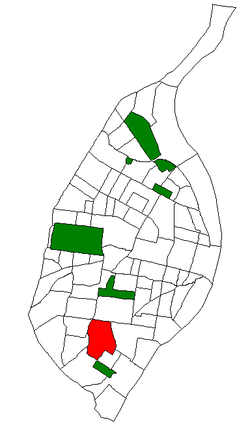
Bevo was a non-alcoholic malt beverage, or near beer, brewed in the United States by the Anheuser-Busch company beginning in the early 20th century. Bevo enjoyed its greatest success during the time of Prohibition, when beer, wine and distilled liquors were made illegal for thirteen years.

Anheuser-Busch Companies, LLC, is an American brewing company headquartered in St. Louis, Missouri. Since 2008, it has been wholly owned by Anheuser-Busch InBev SA/NV, now the world's largest brewing company, which owns multiple global brands, notably Budweiser, Michelob, Stella Artois, and Beck's.

Adolphus Busch was the German-born co-founder of Anheuser-Busch with his father-in-law, Eberhard Anheuser. He introduced numerous innovations, building the success of the company in the late 19th and early 20th centuries. He became a philanthropist, using some of his wealth for education and humanitarian needs. His great-great-grandson, August Busch IV, is a former CEO of Anheuser-Busch.
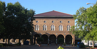
Soulard is a historic neighborhood in St. Louis, Missouri. It is the home of Soulard Farmers Market, the oldest farmers' market west of the Mississippi River. Soulard is one of ten certified local historic districts in the city of St. Louis.

Ballpark Village (BPV) is a dining and entertainment district in Downtown St. Louis, Missouri, owned by the investment group that controls the St. Louis Cardinals, the city's professional baseball team. Located on the 200 and 300 blocks of Clark Street, it sits across the street from and is meant to complement Busch Stadium, the team's home field, on the site of the demolished Busch Memorial Stadium.

August Anheuser Busch Sr. was an American brewing magnate who served as the President and CEO of Anheuser-Busch, based in St. Louis, Missouri, from 1913 to 1934. It became the world's largest brewery in 1957 under direction of his son August A. "Gussie" Busch Jr.
Bosnian Americans are Americans whose ancestry can be traced to Bosnia and Herzegovina. The vast majority of Bosnian Americans immigrated to the United States during and after the Bosnian War which lasted from 1992–95. Nevertheless, many Bosnians immigrated to the United States as early as the 19th century. The largest Bosnian-American population can be found in both Greater St. Louis and in Greater Chicago which boast the largest number of Bosnians in the world outside of Europe.

Benton Park West is a neighborhood located in South St. Louis City, Missouri, United States. The neighborhood is bounded by Jefferson Ave. on the east, Gravois Ave. on the north and west, and an irregular boundary consisting of Cherokee Street, S. Compton Ave., and Potomac St. to the south. The neighborhood is the conglomeration of two different neighborhoods in the 1970s, Compton Hill and Marquette-Cherokee. Parts of these two 1970s neighborhoods make up the current day Benton Park West. Marquette-Cherokee was bounded by Arsenal Street on the north, Bates Street on the south and Grand Boulevard on the west. Its eastern edge was the bank of the Mississippi River. Benton Park West has the highest percentage of Latino residents among St. Louis neighborhoods.

Benton Park is a neighborhood in southside St. Louis, Missouri, just west of the Soulard neighborhood. The official boundaries of the area are Gravois Avenue on the north, Cherokee Street on the south, I-55 on the east, and Jefferson Avenue on the west. Benton Park is unrelated to Benton Place, a private street located in Lafayette Square, St. Louis.

Boulevard Heights is a neighborhood of St. Louis, Missouri. The neighborhood is bounded by Gravois Avenue on the west, Holly Hills Boulevard and Carondelet Park on the north, South Grand Avenue and I-55 on the east, and the city limits on the south.

Dutchtown is a neighborhood of St. Louis, Missouri. It is called "Dutch" from Deutsch, i.e., "German", as it was the southern center of German-American settlement in St. Louis in the early 19th century. It was the original site of Concordia Seminary, Concordia Publishing House, Lutheran Hospital, and other German community organizations. The German Cultural Society still has its headquarters there. St Anthony of Padua Catholic Church towers over the neighborhood and is a symbol of the neighborhood.

Fox Park is a neighborhood of St. Louis, Missouri. The neighborhood borders are Jefferson Avenue to the east, Interstate 44 to the north, Gravois Avenue to the south and Nebraska Avenue to the west. Surrounding neighborhoods include the Gate District, Compton Heights, Tower Grove East, Benton Park West and McKinley Heights.
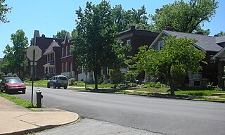
Gravois Park is a historic neighborhood of St. Louis, Missouri. Roughly bounded by Jefferson Avenue, Chippewa Street, Grand Boulevard, and Cherokee Street, the Gravois Park neighborhood is a diverse mix of homeowners, renters, and businesses. The area's architecture reflects its settlement at the turn of the 20th century. The namesake park dates from 1812, and was praised for its beauty in the nineteenth century already, and in 1914 was part of a walking tour of the city meant to show off the City Plan Commission's "idealized view of the shape of the city."

Holly Hills is a neighborhood in South St. Louis, Missouri, near the intersection of I-55 and Loughborough Avenue. The neighborhood is defined by Bates and Walsh on the Northeast, Holly Hills on the Southwest, Morganford Street on the Northwest, and Grand Boulevard on the Southeast. It is surrounded by Carondelet Park and the Boulevard Heights, Bevo Mill, Dutchtown and Carondelet neighborhoods.

McKinley Heights is a historic conservation neighborhood located in the near South Side of the City of St. Louis. It was rated as a Top 10 Neighborhood for young adults in the St. Louis metropolitan area. The neighborhood is bounded by I-44 to the north, Jefferson Avenue to the west, and I-55 and Gravois Boulevard to the east and south. There are restaurants and entertainment in the adjacent Soulard and Lafayette Square neighborhoods. Three bus routes provide a commute downtown or throughout the City. There are three churches and several neighborhood businesses. There is also 1 6th-12th Grade High School, McKinley Classical Leadership Academy
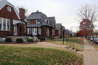
Princeton Heights is a neighborhood of St. Louis, Missouri. The neighborhood boundaries are defined as Hampton Boulevard on the west, Eichelberger on the north, Christy Boulevard on the east, and Gravois on the south.
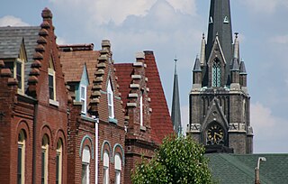
Tower Grove East is a neighborhood of St. Louis, Missouri. The Tower Grove East neighborhood is bordered by Shenandoah Avenue to the north, Nebraska Avenue to the east, Gravois Avenue to the south, and south Grand Boulevard to the west.
The streets of St. Louis, Missouri, United States, and the surrounding area of Greater St. Louis are under the jurisdiction of the City of St. Louis Street Department. According to the department's Streets Division, there are 1,000 miles (1,600 km) of streets and 600 miles (970 km) of alleys within the city.
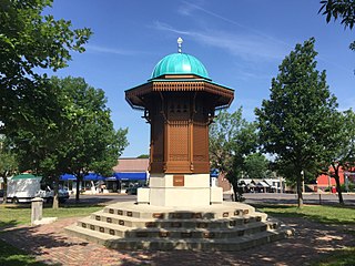
The city of St. Louis, Missouri, and the metropolitan area is tied with Chicago, Illinois for the largest Bosnian American population in the United States, and has the largest Bosnian population outside of Bosnia and Herzegovina. The highest concentration of Bosnians in St. Louis is in the "Little Bosnia" neighborhood of Bevo Mill. The Bosnian cultural imprint can be seen in the numerous Bosnian restaurants, bakeries, and cafes, as well as several Bosnian mosques and religious organizations.

Steve Mizerany was an American business owner and media personality. Mizerany was known in St. Louis, Missouri for the outsized personality he displayed as the star of his own advertisements.

