
The Central West End is a neighborhood in St. Louis, Missouri, stretching from Midtown's western edge to Union Boulevard and bordering on Forest Park with its outstanding array of free cultural institutions. It includes the Cathedral Basilica of Saint Louis on Lindell Boulevard at Newstead Avenue, which houses the largest collection of mosaics in the world. The Central West End is represented by three aldermen as it sits partially in the 17th, 18th, and 28th Wards.

The Grand Center Arts District is located in the Midtown St. Louis Historic District north of the Saint Louis University campus. Referred to colloquially as Grand Center, the neighborhood's formal name is Covenant Blu Grand Center. The neighborhood's is a member of the Global Cultural Districts Network.

St. Louis is located at 38°38′53″N90°12′44″W.

Shaw is a neighborhood in St. Louis, Missouri. It is bordered on the North by Interstate 44, the east by S. Grand Blvd, the west by Tower Grove Ave and the Missouri Botanical Gardens, and the south by Tower Grove Park. The Shaw Neighborhood is a local historic district whose historic structure and character is protected by ordinance.
Wydown/Skinker is a neighborhood in St. Louis, Missouri. Washington University in St. Louis is located just north of this neighborhood. The neighborhood is bounded by the city limits on the west, Forsyth Boulevard on the north, Forest Park on the east and Clayton Avenue on the south. The Missouri Historical Society Library & Research Center is located in the Wydown/Skinker neighborhood.

Southampton is a neighborhood in St. Louis, Missouri. Located in the southwestern reaches of the city, its borders are Chippewa Street on the north, Hampton Avenue on the west, Eichelberger Street on the south, and South Kingshighway Boulevard on the east.

Benton Park West is a neighborhood located in South St. Louis City, Missouri, United States. The neighborhood is bounded by Jefferson Ave. on the east, Gravois Ave. on the north and west, and an irregular boundary consisting of Cherokee Street, S. Compton Ave., and Potomac St. to the south. The neighborhood is the conglomeration of two different neighborhoods in the 1970s, Compton Hill and Marquette-Cherokee. Parts of these two 1970s neighborhoods make up the current day Benton Park West. Marquette-Cherokee was bounded by Arsenal Street on the north, Bates Street on the south and Grand Boulevard on the west. Its eastern edge was the bank of the Mississippi River. Benton Park West has the highest percentage of Latino residents among St. Louis neighborhoods.

Midtown is a neighborhood in St. Louis, Missouri. It is located 3 miles (4.8 km) west of the city riverfront at the intersection of Grand and Lindell Boulevards. It is home to the campus of Saint Louis University and the Grand Center Arts District.

Clifton Heights is a neighborhood of St. Louis, Missouri, US, located along the southwest border of the city and highlighted by a park — Clifton Park (38.6143°N 90.2916°W) — with a playground and a lake.
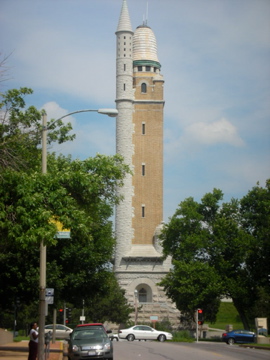
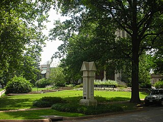
The Compton Heights historic neighborhood, located near the south side of St. Louis, Missouri in the shadow of the great water tower of Reservoir Park is one of the earliest planned residential developments of the American nineteenth century. Laid out in 1889 in accordance with a plan that viewed nature as a neighbor and not as an enemy to be subjugated by some rectilinear grid, its wide setbacks and curving streets create remarkable vistas, which are punctuated by more than 200 homes of extraordinary and varied interest. The entire neighborhood is a national historic district.

Forest Park Southeast (FPSE) is a neighborhood of St. Louis, Missouri. It is bordered by Interstate 64 to the north, Vandeventer Avenue to the east, Interstate 44 to the south, and Kingshighway Boulevard and Forest Park to the west. Adjoining neighborhoods include Kings Oak and The Hill to the west, Southwest Garden to the south, Botanical Heights to the southeast, Midtown to the east, and the Central West End to the north.

Fox Park is a neighborhood of St. Louis, Missouri. The neighborhood borders are Jefferson Avenue to the east, Interstate 44 to the north, Gravois Avenue to the south and Nebraska Avenue to the west. Surrounding neighborhoods include the Gate District, Compton Heights, Tower Grove East, Benton Park West and McKinley Heights.
Hi-Pointe is a neighborhood of St. Louis, Missouri, within a section known as Dogtown. It is bounded by Clayton Avenue and Oakland Avenue on the north, City Limits on the west, Dale Avenue on the south, and Louisville Avenue on the east. It is bordered by the Skinker-DeBaliviere neighborhood and Forest Park on the north, the Clayton-Tamm neighborhood on the east, the Franz Park neighborhood on the south and the city of Richmond Heights, part of St. Louis County on the west.

St. Louis Hills is a neighborhood in St. Louis, Missouri. The neighborhood, which is home to the Chippewa location of Ted Drewes Frozen Custard, is situated in the southwest part of St. Louis. It is bounded by Chippewa Street to the northwest and north, Hampton Avenue to the east, Gravois Avenue to the southeast, and the St. Louis county border to the southwest.

Kosciusko is a mostly non-residential neighborhood located in St. Louis, Missouri. It begins at the Mississippi River front in the east and goes up to 7th Boulevard and 8th Street in the west. Interstate 55 is a northern border, and St. George and Dorcas Streets border the south of this neighborhood. Kosciusko is named in honor of Tadeusz Kościuszko, an American Revolutionary war general of Polish descent.

Botanical Heights is a neighborhood of St. Louis, Missouri. Its former name was McRee Town. The Botanical Heights neighborhood is defined by Chouteau Avenue on the North, Interstate 44 on the South, 39th Street on the East and Vandeventer Avenue on the West. This near Southside neighborhood is located just north of the Shaw neighborhood.

Mark Twain is a neighborhood of St. Louis, Missouri named after author and Missouri native Mark Twain. It is located between Interstate 70 and Bellefontaine Cemetery.
Peabody–Darst–Webbe is a neighborhood of St. Louis, Missouri. It is also called the Near Southside neighborhood. Peabody–Darst–Webbe is an area bounded by S. Tucker Blvd. on the east, Chouteau Ave. on the north, Dolman Street on the west, and the I-55/I-44 interchange on the south.

Tower Grove South is a neighborhood of south St. Louis, Missouri. Formerly known as Oak Hill, Tower Grove South is bounded by Arsenal Street on the north, Chippewa Street on the south, Kingshighway Boulevard on the west, and Grand Boulevard on the east. The majority of the neighborhood was built following the extension of streetcar lines from downtown St. Louis. Commercial development in the neighborhood is concentrated on Grand Boulevard in the east and Morganford Road in the west of the neighborhood. There are also scatterings of commercial and mixed use buildings on interior intersections.

Clayton-Tamm is a historic St Louis neighborhood and once an Irish-American enclave located near the western border of St. Louis, Missouri, USA, just south of Forest Park.

