Budo–Su-ngai Padi National Park

Last updated • 2 min readFrom Wikipedia, The Free Encyclopedia
Budo–Su-ngai Padi National Park
อุทยานแห่งชาติบูโด-สุไหงปาดี
Thailand location relief map.svg
Red pog.svg
Map of Thailand
LocationSouthern Thailand
Coordinates 6°28′01″N101°37′48″E / 6.467°N 101.630°E / 6.467; 101.630 [1]
Area294 km2 (114 sq mi)
Established1999
http://web3.dnp.go.th/parkreserve/asp/style1/default.asp?npid=119&lg=2 [ permanent dead link ]

Budo–Su-ngai Padi National Park (Thai : อุทยานแห่งชาติบูโด-สุไหงปาดี) is a national park in Narathiwat Province, Thailand. It is part of Sankala Khiri mountain range, the southernmost subrange of the Tenasserim Hills. [3]

Contents

History

The area was a haven for guerrillas and few people ventured in to see the natural jungle environment here.[ citation needed ] However, when the situation improved in 1974, the Royal Forest Department established Pacho Waterfall Park that became Budo–Su-ngai Padi National Park.

Geography and climate

The park has an area of 294 square kilometres (114 sq mi) and covers parts of Narathiwat, Yala and Pattani Provinces. The Budo mountain range is part of the Indo-Malayan equatorial tropical rainforest that has high humidity because of the year-round rainfall that it gets.

The park has several waterfalls, such as Phu Wae, Pacho and Pako. The best known and accessible is "Pacho", on a high cliff. The word "pacho" is a Thai adaption/variant of the Malay word pancur meaning "waterfall".

Flora and fauna

The most distinctive plant is the "golden leaves" or "yandao". This plant was first discovered here in 1988. The vine leaves are gold in colour, similar to a hardwood tree of the genus Bauhinia , but considerably larger. Some leaves are even larger than the palm of a hand. The edges of the leaves are curved throughout, like two connected ovals. The leaves have a soft velvet-like texture. Rare animals in the area are rhinoceros, agile gibbons, tapirs, and Sumatran serows. The most important animal is the spectacled langur that inhabits Southeast Asia, from the south of Myanmar and Thailand all the way to Malaysia and some islands. It lives in high mountains and deep jungles in groups of around 30-40. The strongest male is the leader. The langur is usually shy, afraid of humans and not aggressive like monkeys. Apart from the spectacled langur, there are three other types in Thailand; banded langurs, gray langurs, and northern spectacled langurs. All four species of langurs are endangered mammals.

Related Research Articles

<span class="mw-page-title-main">Pattani province</span> Province of Thailand

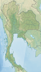
Pattani is one of the southern provinces of Thailand. Neighboring provinces are Narathiwat, Yala, and Songkhla. Its capital is the town of Pattani.

<span class="mw-page-title-main">Narathiwat province</span> Province of Thailand

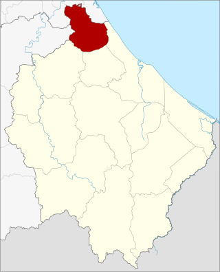
Narathiwat is one of the southern provinces (changwat) of Thailand. Neighboring provinces are Yala and Pattani. To the south it borders the Malaysian state of Kelantan and Perak. The southern railway line ends in this province, which is one of the nation's four provinces that border Malaysia. The province features a range of cultures as well as natural resources, and is relatively fertile. Narathiwat is about 1,140 kilometers south of Bangkok and has an area of 4,475 km2 (1,728 sq mi). Seventy-five percent of the area is jungle and mountains and has a tropical climate.

<span class="mw-page-title-main">Yala province</span> Province of Thailand

Yala is the southernmost Province (changwat) of Thailand. Neighboring provinces are Songkhla, Pattani, and Narathiwat. Yala is one of two landlocked provinces in southern Thailand, the other being Phatthalung. Its southern part borders Kedah and Perak of Malaysia.

<span class="mw-page-title-main">Khao Sok National Park</span> National park in Surat Thani, Thailand

Khao Sok National Park is in Surat Thani Province, Thailand. Its area is 461,712 rai ~ 739 square kilometres (285 sq mi), and it includes the 165 km2 (64 sq mi) Cheow Lan Lake contained by the Ratchaprapha Dam. The park is the largest area of virgin forest in southern Thailand and is a remnant of rain forest which is older and more diverse than the Amazon rain forest.

<span class="mw-page-title-main">Khao Yai National Park</span> National park in Thailand

Khao Yai National Park is a national park in Thailand. Established in 1962 as Thailand's first national park, it is the third largest national park in Thailand.

<span class="mw-page-title-main">Titiwangsa Mountains</span> Mountain range in Thailand and Malaysia

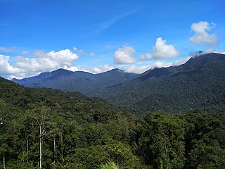
The Titiwangsa Mountains, also known as Banjaran Besar by locals, is the chain of mountains that forms the backbone of the Malay Peninsula. The northern section of the range is in southern Thailand, where it is known as the Sankalakhiri Range.

<span class="mw-page-title-main">Su-ngai Kolok</span> Subdistrict and town municipality in Narathiwat, Thailand

Su-ngai Kolok is a border town and subdistrict on the Malaysia-Thailand Border in Su-ngai Kolok District, Narathiwat Province, Thailand. It is one of the largest and most prosperous districts in Narathiwat Province. It is also one of the major economic centers in the southern part of Thailand. It is capital of the Su-ngai Kolok District. As of 2005, the town had a population of 38,612. Across the border is Rantau Panjang, Kelantan, Malaysia.

<span class="mw-page-title-main">Ra-ngae district</span> District in Narathiwat, Thailand

Ra-ngae is a district (amphoe) in Narathiwat province, southern Thailand.

<span class="mw-page-title-main">Waeng district</span> District in Narathiwat, Thailand

Waeng is the southernmost district (amphoe) of Narathiwat province, southern Thailand.

<span class="mw-page-title-main">Tak Bai district</span> District in Narathiwat, Thailand

Tak Bai is a district (amphoe) in the southeastern part of Narathiwat province, southern Thailand.

<span class="mw-page-title-main">Sukhirin district</span> District in Narathiwat, Thailand

Sukhirin is a district (amphoe) in the southern part of Narathiwat province, southern Thailand.

<span class="mw-page-title-main">Bacho district</span> District in Narathiwat, Thailand

Bacho is the northernmost district (amphoe) of Narathiwat province, southern Thailand.

Khao Luang is the tallest mountain in southern Thailand. It is in Nakhon Si Thammarat Province.

<i>Aglaia lawii</i> Species of tree in the Meliaceae from Tropical Asia and China

Aglaia lawii is a species of tree in the family Meliaceae. As well as the autonym species, there are two subspecies accepted.

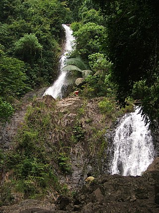
Chat Warin Waterfall is a waterfall in Tambon To Teng, near Narathiwat, Thailand. The entrance is a good asphalt road in Budo–Su-ngai Padi National Park. This is a medium-sized waterfall that has water year round and is shady from the many trees in the area.

<span class="mw-page-title-main">Khao Phanom Bencha National Park</span> National park in Thailand

Khao Phanom Bencha National Park is a national park in Krabi Province, Thailand. The park is named for Khao Phanom Bencha mountain and protects an area of virgin rainforest and rare wildlife.

<span class="mw-page-title-main">Khao Lak–Lam Ru National Park</span> National park in Thailand

Khao Lak–Lam Ru National Park is a national park in Phang Nga Province, Thailand. The park is named for two of its mountain peaks, Khao Lak and Lam Ru. It also encompasses beaches and forests.

<span class="mw-page-title-main">Phu Phan National Park</span> National park in Thailand

Phu Phan National Park is a national park in Sakon Nakhon and Kalasin provinces, Thailand. This isolated park covers a wide jungle area in the Phu Phan Mountains of Isan.

Khun Phawo National Park is a national park in the Mae Ramat District, Tak Province, Thailand.

Princess Sirindhorn Wildlife Sanctuary, or popularly known as Pa Phru To Daeng (ป่าพรุโต๊ะแดง), or just called Phru To Daeng (พรุโต๊ะแดง) is a largest and most fertile peat swamp forest in Thailand covering an area of 125,625 rais, about 4.9654 km2 (49,654 a) in Mueang Narathiwat, Tak Bai, Su-ngai Kolok, and Su-ngai Padi districts of Narathiwat province in southern Thailand. It is about 6 km from Su-ngai Kolok railway station.

References

  1. "Budo-Sungai Padi". Protected Planet . Retrieved 26 October 2022.
  2. "Budo-Sungai Padi". Protected Planet . Retrieved 26 October 2022.
  3. "Budo - Su-ngai Padi National Park". Department of National Parks (DNP) Thailand. Archived from the original on 10 July 2015. Retrieved 9 July 2015.