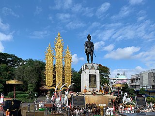
Chiang Rai is one of Thailand's seventy-six provinces, which lies in upper northern Thailand and is Thailand's northernmost province. It is bordered by the Shan State of Myanmar to the north, Bokeo province of Laos to the east, Phayao to the south, Lampang to the southwest, and Chiang Mai to the west. The provinces is linked to Houayxay Laos by the Fourth Thai–Lao Friendship Bridge that spans the Mekong.

Loei, is one of the more sparsely populated provinces (changwat) of Thailand. It lies in the Isan region of upper northeastern Thailand. Neighboring provinces are Nong Khai, Udon Thani, Nong Bua Lamphu, Khon Kaen, Phetchabun, and Phitsanulok. In the north it borders Xaignabouli and Vientiane province of Laos.

Kalasin is one of Thailand's seventy-six provinces (changwat), located in upper northeastern Thailand, also called Isan. The province was established by the Act Establishing Changwat Kalasin, BE 2490 (1947), and it came into existence on 1 October 1947. Neighboring provinces are Sakon Nakhon, Mukdahan, Roi Et, Maha Sarakham, Khon Kaen, and Udon Thani.

Phayao is one of Thailand's seventy-seven provinces (changwat) lies in upper northern Thailand. Neighboring provinces are Nan, Phrae, Lampang, and Chiang Rai. In the northeast it borders Xaignabouli of Laos.

Nakhon Phanom province is one of Thailand's seventy-six provinces (changwat) lies in upper northeastern Thailand also called Isan. Directly adjacent provinces are : Mukdahan, Sakon Nakhon, and Bueng Kan. To the northeast it borders Khammouan of Laos.

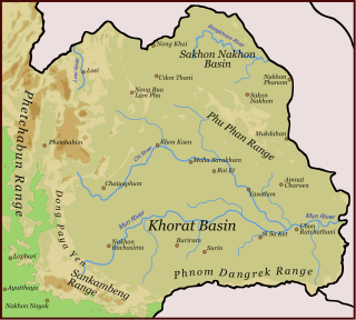
The Phu Phan mountains are a range of hills dividing the Khorat Plateau of the Isan region of Thailand into two basins: the northern Sakhon Nakhon Basin, and the southern Khorat Basin.
Dong Phaya Yen or Dong Phya Yen is a mountain range in Phetchabun, Chaiyaphum, Lopburi, Saraburi, and Nakhon Ratchasima Provinces, Thailand.

Phu Kradueng National Park, in the Si Than sub-district of Amphoe Phu Kradueng, Loei Province, is one of the best known national parks of Thailand. It has a high point of 1,316 m (4318 ft) elevation at Khok Moei. It was proclaimed a national park on 23 November 1962, making it the second national park of Thailand after Khao Yai National Park.

Thoeng is a district (amphoe) in the eastern part of Chiang Rai province, northern Thailand.
Doi Phu Kha National Park covers a part of 8 districts in the Luang Prabang Range, Nan Province, Northern Thailand and has rich natural resources. It is Northern Thailand's largest National park and rivers such as Nan River and Pua River, have their sources within the area of the range under the protection of the park limits. Khun Nan National Park is located north of the park area.

The Luang Prabang Range, named after Luang Prabang, is a mountain range straddling northwestern Laos and Northern Thailand. Most of the range is located in Sainyabuli Province (Laos), as well as Nan and Uttaradit Provinces (Thailand), with small parts in Phitsanulok and Loei Provinces. Several rivers such as the Nan, Pua and Wa rivers, have their sources in this range. Phu Fa waterfall, the biggest and the tallest waterfall in Nan Province, is also located in these mountains. This range is part of the Luang Prabang montane rain forests ecoregion.
Doi Mae Tho, also known as Doi Langka Luang (ดอยลังกาหลวง) or Doi Lang Ka (ดอยลังกา), is a mountain in Thailand, part of the Khun Tan Range.
Doi Phu Nang National Park is a national park in Dok Khamtai, Pong and Chiang Muan Districts, Phayao Province, Thailand.

The Phi Pan Nam Range, also Pee Pan Nam, is a 400 km (249 mi) long system of mountain ranges in the eastern half of the Thai highlands. It is mostly in Thailand, although a small section in the northeast is within Sainyabuli and Bokeo Provinces, Laos.
Phu Chi Fa, also Phu Chee Fah, is a mountain area and national forest park in Thailand. It is located at the northeastern end of the Phi Pan Nam Range, 12 km to the southwest of Doi Pha Tang at the eastern edge of Tap Tao in Thoeng District, Chiang Rai Province.

Tat Ton National Park is a national park in Chaiyaphum Province, Thailand. The park is in the Laen Kha mountain range. It features waterfalls and mountain highland scenery. On 31 December 1980, Tat Ton was designated Thailand's 23rd national park.

Khun Chae National Park is a national park in Chiang Rai Province, Thailand. This rugged park is home to high mountains and waterfalls.
Lam Nam Nan National Park is a national park in Thailand's Phrae and Uttaradit provinces. The national park covers an area of 999 square kilometres (386 sq mi) and was established in 1998, it is home to rugged mountains and the reservoir of the Sirikit Dam.

