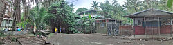
Bugandi

Last updated

Bugandi
Suburb
Atzurasettlementslshops.jpg
Typical business area off Mountain Crescent - Boundary / Atzera Settlements. Church to left, shops to right. Improvised pedestrian bridge over creek
1200px Lae suburban map of Papua New Guinea.png
Red pog.svg
Bugandi
Location in Lae
Coordinates: 6°42′50″S146°58′11″E / 6.71389°S 146.96972°E / -6.71389; 146.96972 Coordinates: 6°42′50″S146°58′11″E / 6.71389°S 146.96972°E / -6.71389; 146.96972
CountryFlag of Papua New Guinea.svg  Papua New Guinea
Province Morobe Province
District Lae District
Time zone UTC+10 (AEST)

Bugandi is a suburb of Lae in the Morobe Province, Papua New Guinea.

Contents

Location

Bugandi straddles the Highlands Highway and is located to the West and North of the Lae Golf Club, Eriku and North East of Lae central. According to the Lae Telephone Directory [lower-alpha 1] Atzera settlements are located to the North of the suburb and to the North West of Omili is the Timber Industry Training College.

BugandiHighPanorama.jpg
Bugandi High School Markham Road facing South West. Mount Shungol in background.

Bugandi High School

Bugandi High School was built in 1959 requiring ten acres of rainforest to be cleared so that two classrooms, a dormitory, two houses and a mess could be built. [2] Henry Robert Jack AMESBURY (Bugandi Jack) earned the nickname from his tireless work in establishing a boarding school amidst thick jungle in a swampy area called Bugandi, outside Lae in New Guinea. Carved from the jungle by students who cleared bush, installed drainage and established playing fields, food plots and cattle pens, Bugandi High School established a reputation for academic achievement and the quality of its rugby league players. Many Bugandi graduates went on to become political, business and professional leaders in Papua New Guinea. [3]

In January 1960 the first classes began and by 1968 the school farm grew peanuts, soybeans and pineapples and raised pigs and poultry [2]

In 1965 the school had become a full high school with 257 students but in 1966, Bugandi began enrolling students from all over the New Guinea mainland and forms 3 and 4 were begun [4]

In 1995, Trukai Industries started a rice farming project at Bugandi Secondary School with the aim to promote rice production through Bugandi students with assistance from Trukai Industries field officers. The project also involved a collaborative research work with Papua New Guinea University of Technology on rice pest. [5]

In 1998 the site hosted a trial to determine the potential of using dead cane toads (Bufus marinus) to control rice bug (Leptocorisa species) [6] and a trial to examine the balance between brown planthopper and selected natural enemies [7]

The project was handed over to the school on 17 March 1999 along with a donation of a hand tractor, farming implements, hand tools, fertiliser and chemicals for the next crop. [5] and in 2000 the site was used for food security trials. [8]

In September 2009 a Cholera outbreak affected students from Bugandi High School (and other schools) as a result of the sale of prepared food in the schoolyard markets. [9] In the same month the PNG Ports Corporation Limited announced that port pilots will be able to be trained in Papua New Guinea using simulators and actively recruiting "really bright Grade 12 school leavers" from Bugandi High School to be trained as pilots next year. [10]

In May 2013, students from Bugandi Secondary School and Lae Secondary School (Eriku) engaged in fighting resulting in one death and serious injury of another student [11]

Atzera Range

The Atzera Range starts at Bugandi and runs adjacent to the Markham River has an elevation of 280 meters above sea level. [12] [13]

Anticlines in the vicinity of Lae, such as the Atzera Range and hills near Situm, appear to indicate that the Ramu-Markham Fault (which follows the northern edge of the Markham Valley) changes dip close to the surface from a steep ramp to a shallow fault, breaching the surface south of Lae. [14]

The Lae Seismic Zone has been identified between the Atzera Range and Situm [15] which has the potential to generate shallow Mw~7.0 earthquakes and landslides around the Atzera Range. [14] The possibility of major landsides in this area has increased as a result of human modification to the natural vegetation cover through clearing and gardening. [16]

The 1983 floods remain the worst natural disaster since the establishment of the town in the late 1920s. Hundreds of people at the Five Mile settlement along the Highland Highway were also affected by mud-slides from the Atzera mountain ranges. [17] [18]

Atzera Range during World War II

Before the construction of the Highlands Highway, a road in the Atzera foothills connected Nadzab with Lae and a rough trail on the other side of the Atzeras paralleled this road from Lae to Yalu. Jensen's plantation was located in the Markham Valley and the location of battles between Japanese and Australian soldiers.

On 10 September the 25th Australian Infantry Brigade moved East from Nadzab towards Lae along the Atzera foothills while the 9th Division approached Lae from the East and on 16 September both units converged on Lae [19]

Atzera Hills Project

In 1978 the Human Ecology Programme of the Department of Minerals and Energy, assisted by the UNEP and Unesco (Man and the Biosphere MAB Project 11) and in cooperation with the Lae City Council, instigated the Atzera Hills Project, described as an ecologically sound management system to arrest the rapid deterioration and loss of productive capacity of 600 ha of Atzera Hills. [20]

The Atzera project folded after only three years despite efforts to train and raise awareness on the benefits of charcoal, the uptake in PNG households was minimal. [21]

Improvised bridge on Mountain Crescent AtzeraSettlementBridge.jpg
Improvised bridge on Mountain Crescent
Typical foot lanes. Note the WW2 parts used as fence post. Atzurasettlementslanes.jpg
Typical foot lanes. Note the WW2 parts used as fence post.
Seventh Day Adventist church AtzuraSettlementchurch.jpg
Seventh Day Adventist church

Heavy rains in 2005 resulted in the Morobe administration highlighting the vulnerability of the city to the weather and recommending that a major rehabilitation programme be started immediately to reforest the surrounding hills behind the city to prevent soil erosion. This problem has been exacerbated as a result of the increased number of squatter settlements. [22]

Atzera & Bumbu illegal settlements

Population pressures are produced by population drift which creates a need for land and food as well as squatter settlements, further aggravated by the extended family system particularly evident in the Atzera settlements. [23]

By 1963 there were 400 persons living in the Bumbu settlement (10 percent of the Lae population). By 1976 this same settlement had grown to over 3000 people and in 1980 the population was officially recorded at 4460 persons living in 847 self-help units. [24] In 1990 Bumbu settlement is the largest settlement in Papua New Guinea with 10,000 people spread over 40 hectares and 785 structures. [25]

More than 90 percent of the settlers had been living at Bumbu for more than ten years. [26] [27] Most of the settlers migrated here during the colonial days in search of an easy and better life with money. [28] Settlement buildings are usually made of wood, tin, cardboard and tar paper amongst other material representing a desperate effect to provide shelter. [29]

Notes

  1. Lae telephone directory is available in hard copy only from PNG Directories Limited. Map 3 coordinates I1 to C5. Few online maps adequately depict the relationship to the Atzera settlements and Bugandi. [1]

Related Research Articles

Lae is the capital of Morobe Province and is the second-largest city in Papua New Guinea. It is located near the delta of the Markham River and at the start of the Highlands Highway, which is the main land transport corridor between the Highlands Region and the coast. Lae is the largest cargo port of the country and is the industrial hub of Papua New Guinea. The city is known as the Garden City and home of the University of Technology.

Morobe Province Place in Papua New Guinea

Morobe Province is a province on the northern coast of Papua New Guinea. The provincial capital and largest city is Lae. The province covers 33,705 km2, with a population of 674,810, and since the division of Southern Highlands Province in May 2012 it is the most populous province. It includes the Huon Peninsula, the Markham River, and delta, and coastal territories along the Huon Gulf. The province has nine administrative districts. At least 101 languages are spoken, including Kâte and Yabem language. English and Tok Pisin are common languages in the urban areas, and in some areas pidgin forms of German are mixed with the native language.

Lae Nadzab Airport Domestic airport in Nadzab, Morobe Province, Papua New Guinea

Lae Nadzab Airport is a regional airport located at Nadzab 42 kilometres (26 mi) outside Lae, Morobe Province, Papua New Guinea along the Highlands Highway. It is served by both private and regional aircraft with domestic flights. The airport replaced the Lae Airfield in 1977.

Malahang Suburb in Lae District, Morobe Province, Papua New Guinea

Malahang is a suburb of Lae, Morobe Province in Papua New Guinea.

Nadzab Village is in the Markham Valley, Morobe Province, Papua New Guinea on the Highlands Highway. Administratively, it is located in Gabsongkeg ward of Wampar Rural LLG. The Nadzab Airport is located East of Nadzab Village and was the site of the only Allied paratrooper assault in New Guinea on 5 September 1943.
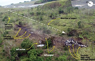
Lae Airfield

Lae Airfield is a former World War II airfield and later, civilian airport located at Lae, Morobe Province, Papua New Guinea. The airport was closed in the 1980s, in favour of Lae Nadzab Airport, which was able to accommodate larger jet aircraft. The airport was also known as Lae Drome or Lae Aerodrome.

Butibum Suburb in Lae District, Morobe Province, Papua New Guinea

Butibam is a village on the outskirts of Lae, Morobe Province in Papua New Guinea.

Taraka is a suburb of Lae in the Morobe Province, Papua New Guinea. The main campus for the Papua New Guinea University of Technology is located in Taraka.

Tent City is a suburb of Lae in the Morobe Province, Papua New Guinea. The main campus for the Papua New Guinea University of Technology is located 1 kilometre to the South of Tent City.

Bumayong is an outer suburb of Lae in the Morobe Province, Papua New Guinea.

Situm Ex-Servicemen Block in Morobe Province, Papua New Guinea

Situm is a government ex-servicemen block outside of Lae in Labuta Rural LLG, Morobe Province, Papua New Guinea.

Dowsett is a suburb of Lae in the Morobe Province, Papua New Guinea.

Bumneng is a suburb of Lae in the Morobe Province, Papua New Guinea.

Eriku is a suburb of Lae in the Morobe Province, Papua New Guinea.

The Lae Botanic Gardens are located in Bumneng, Eriku and Lae City in the Morobe Province, Papua New Guinea. Within this location is the Papua New Guinea Forest Research Unit, the Papua New Guinea National Herbarium and the Lae War Cemetery.

Yalu, Papua New Guinea Village in Morobe Province, Papua New Guinea

Yalu is a large village in Wampar Rural LLG, located in the Markham Valley of Morobe Province, Papua New Guinea. It lies along the Highlands Highway 21.5 kilometres (13.4 mi) north-west of Lae, 7 kilometres (4.3 mi) southeast of Nadzab. The landscape is typically lowland rainforest.

3 Mile, Lae Suburb in Lae District, Morobe Province, Papua New Guinea

3 Mile is a suburb of Lae in the Morobe Province, Papua New Guinea.

6 Mile is a suburb of Lae in the Morobe Province, Papua New Guinea.

9 Mile is a large village in the Markham Valley of Morobe Province, Papua New Guinea. It lies along the Highlands Highway 9 miles (14 km) from the center of Lae between the foothills of the Atzera Range and the Markham River. The Atzera Range starts at Bugandi and runs adjacent to the Markham River has an elevation of 280 meters above sea level. northwest of Lae, 7 kilometres (4.3 mi) southeast of Nadzab. The landscape is typically lowland rainforest.

History of Lae

As the township of Lae, in Morobe Province, Papua New Guinea is a relatively new entity, the history of the Lae environs is much older.

References

  1. "Papua New Guinea (PNG) White Pages - Telephone Directory". Archived from the original on 25 March 2014. Retrieved 28 February 2014. Papua New Guinea White Pages
  2. 1 2 MURRELL, DENIS (19 July 2010). "A boys school in the sixties – a Bugandi story". Keith Jackson & Friends: PNG ATTITUDE. Retrieved 28 February 2014.
  3. "Vale, September 2013". Papua New Guinea Association of Australia. September 2013. Retrieved 28 February 2014.
  4. NALU, MALUM (9 July 2010). "Remembering Bugandi the way it used to be" . Retrieved 28 February 2014.
  5. 1 2 Trukai Industries (June 1999). "BUGANDI PROJECT HAND OVER" (PDF). The Rice Relay. 4 (2). Archived from the original (PDF) on 3 March 2014. Retrieved 28 February 2014.
  6. "Dead Cane toads trial" (PDF). The Rice Relay. 4 (2). March 1999. Archived from the original (PDF) on 3 March 2014. Retrieved 28 February 2014.
  7. Trukai Industries (May 1998). "PLANTHOPPER & NATURAL ENEMY MONITORING" (PDF). The Rice Relay. 3 (5). Archived from the original (PDF) on 3 March 2014. Retrieved 28 February 2014.
  8. Bourke, Allen and Salisbury (26–30 June 2000). "Proceedings of the Papua New Guinea Food and Nutrition 2000 Conference, PNG University of Technology, Lae" (PDF). Retrieved 28 February 2014.
  9. GUMAR, PISAI (9 September 2009). "Lae schools shut down". The National. Retrieved 28 February 2014.
  10. "PNG Ports eyes more pilotage training". The National. 1 September 2009. Retrieved 28 February 2014.
  11. Lahoc, Gabriel (28 May 2013). "One Dead, Another Hospitalized After PNG School Fight". The National. Retrieved 27 February 2014.
  12. "Atzera Range". GeoView. Retrieved 28 February 2014.
  13. "Atzera Range". TravelsRadiate. Archived from the original on 4 March 2014. Retrieved 28 February 2014.
  14. 1 2 43rd Association of Surveyors PNG Congress, Lae; Richard Stanaway; Laura Wallace; Zebedee Sombo; Johnson Peter; Trevor Palusi; Ben Safomea; John Nathan (12–15 August 2009). "Lae, a City caught between two plates - 15 years of Deformation Measurements with GPS" (PDF). Focus On Challenges; Society-Space-Surveyors. Retrieved 28 February 2014.
  15. Kulig, Christopher; McCaffrey, Robert; Abers, Geoffrey A.; Letz, Horst (November 1993). "Shallow seismicity of arc-continent collision near Lae, Papua New Guinea". Tectonophysics. 1. 227 (1–4): 81–93. Bibcode:1993Tectp.227...81K. doi:10.1016/0040-1951(93)90088-2.
  16. Tau, Asigau. "Lae - Nabzad Development Plan Using Gis". Secretariat of the Pacific Community. Archived from the original on 5 March 2014. Retrieved 28 February 2014.
  17. dfdfd. "ttt". 20 (1).{{cite journal}}: Cite journal requires |journal= (help)
  18. KAITILLA, S & YAMBUI , A (1996). "Intervention in PNG: The Case of Lae" (PDF). Disaster Management and Government. 20 (1): 61–63. doi:10.1111/j.1467-7717.1996.tb00515.x. PMID   8867511. Archived from the original (PDF) on 4 March 2014. Retrieved 28 February 2014.
  19. Miller (jnr), John. "CHAPTER XI The Markham Valley and the Huon Peninsula". Hyperwar. Retrieved 28 February 2014.
  20. DUBE, V.N (1983). "Firewood Cropping, Food Cultivation, and Conservation Planting: A Three-Dimensional Strategy for Displaced Rural Communities: The Case of the Atzera Hills, Lae, Papua New Guinea" (PDF). Mountain Research and Development. Lae City Interim Authority. 3 (4): 422–428. doi:10.2307/3673051. JSTOR   3673051 . Retrieved 28 February 2014.
  21. Murphy, MEG (2009). What is free about fuelwood? A critique of the value of fuelwood in the rural and squatter settlement households in the Eastern Highlands of Papua New Guinea. PhD thesis, Southern Cross University.
  22. Editorial (7 September 2005). "PNG'S LAE IN NEED OF MAJOR REHABILITATION". Post Courier. Archived from the original on 4 March 2014. Retrieved 28 February 2014.
  23. Catalyst. Melanesian Institute for Pastoral & Socio-Economic Service. 1985. p. 34.
  24. In Search of a Home. editorips@usp.ac.fj. 1987. pp. 181–. ISBN   978-982-01-0016-9.
  25. Denis Murphy (1990). A Decent Place to Live: Urban Poor in Asia. Asian Coalition for Housing Rights, Habitat International Coalition-Asia. ISBN   978-971-501-400-7.
  26. KAITILLA, S (1994). "Post-occupancy evaluation in self-help housing schemes". Cities. Web of Science. 11 (5): 312–324. doi:10.1016/0264-2751(94)90084-1.
  27. John Connell (28 July 2005). Papua New Guinea: The Struggle for Development. Routledge. p. 244. ISBN   978-1-134-93831-5.
  28. Wiri Yakaipoko (2000). The Blue Logic: Something from the Dark Side of Port Moresby. University of Papua New Guinea Press. ISBN   978-9980-84-092-9.
  29. Guillaume Iyenda (30 December 2007). Households' livelihoods and survival strategies among Congolese urban poor: alternatives to Western approaches to development. Edwin Mellen Press. ISBN   978-0-7734-5269-5.