Malahang

Last updated
Malahang
Suburb
Ampo-St-Andrews-Lutheran-church.jpg
Panoramic photo St Andrews Lutheran Church, Evangelical Lutheran Church of Papua New Guinea Headquarters- Ampo
1200px Lae suburban map of Papua New Guinea.png
Red pog.svg
Malahang
Location in Lae
Coordinates: 6°43′10″S147°0′30″E / 6.71944°S 147.00833°E / -6.71944; 147.00833 Coordinates: 6°43′10″S147°0′30″E / 6.71944°S 147.00833°E / -6.71944; 147.00833
CountryFlag of Papua New Guinea.svg  Papua New Guinea
Province Morobe Province
District Lae District
Time zone UTC+10 (AEST)

Malahang is a suburb of Lae, Morobe Province in Papua New Guinea.

Contents

Location

Malahang is located North East of Lae, Morobe Province, Papua New Guinea on Busu Road across the Bumbu River.

Malahangbeachpanorama.jpg
Panoramic photo of Malahang beach. To the right is the remains of SS Myoko Maru (1939) a Japanese cargo ship. To the left is one of the Malahang community houses.

History

In the late 1800s the German New Guinea Company arrived on Neu Guinea (German New Guinea), [1] to select land for plantation development on the north-east coast of New Guinea and establish trading posts.

The Lutheran Malahang Mission Station was established around the same time as the various coconut plantations located opposite the Malahang Industrial Area.

Area around the old Malahang airstrip facing South East. The rebuilt Japanese runway was located to the left side of the photo where the Malahang Industrial estate is located MalahangairstripFacingSE.jpg
Area around the old Malahang airstrip facing South East. The rebuilt Japanese runway was located to the left side of the photo where the Malahang Industrial estate is located

On 8 March 1942 the Imperial Japanese landed at Malahang Beach as part of the Invasion of Lae-Salamaua during World War II. Malahang airfield was upgraded by the Japanese so the runway was 800 feet (240 m) long by 50 feet (15 m) wide and used as satellite of Lae Airport.

On 8 January 1943, the cargo ship Myoko Maru was damaged by an aerial attack by United States Army Air Forces aircraft during the Battle of Wau, and was subsequently beached and abandoned at Malahang Beach.

Malahang health complex, Possible location of Malahang Hospital Malahanghealth.jpg
Malahang health complex, Possible location of Malahang Hospital

The area was liberated by the Australian 9th Division on 14 September 1943. The airfield was subsequently abandoned.

In September 1943, the 2nd Australian Corps Signals (AIF)relieved Signals 1 Australian Corps. [2] In Australians At War, Signalman John Tesoriero writes;

"In September 1943, the unit moved to Lae, boarding their ships at Buna. While we collapsed absolutely exhausted onto the pebbles, a line of vehicles arrived out of the darkness. They were field ambulances carrying wounded men from the 9th Division assault on Lae just a matter of days ago. They were loaded onto one of the LSTs. We slept where we fell. Not even the light shower which fell onto our faces before dawn made any difference. We were a little north of the Lae township, at Malahang Beach. Just inland, overlooking the beach, we made out a big hill blasted by aerial bombing, which they said was honeycombed with caves containing Japanese supplies, big guns pointed out to sea, and a number of enemy troops. The effective bombing had sealed up many enemy in its shattered mess." [3]

During WW2, No. 41 Wing RAAF relocated the 332 radar station from Port Moresby to Lae and to the airfield. Sgt. Bill Humphries who provided the following account of the installation;

"We arrived at Lae two days after it was taken and found the place devastated and the stench nauseating. Open tunnels in the scarp were a mute reminder of where many Japanese chose to be entombed rather than surrender. The Americans moved in, sealed off the tunnels and generally cleared up the area. Australians were setting up a cemetery and we were able to service their technical equipment when required. The station was erected on top of the scarp, all gear being manhandled up".
"After six weeks operation a decision was made to move the station to the vicinity of the unused airstrip at Malahang where lack of local knowledge led to a disaster. The camp and radar were set up on a grassy plain which belied the fact that during the wet season it became a racing waterway. When the wet season arrived the camp was washed out". [4]

In 1992 the Veterans' Review Board (Australia) [lower-alpha 1] heard evidence where the applicant stated;

"I recall that on one occasion I had to visit Lae, on the north coast of New Guinea. Lae had just been recaptured from the Japanese. I had gone there to pay personnel. I recall that the odour of death was everywhere. The destruction was also horrific. I can still smell that odour to this day".

Malahang Airfield

The Malahang airfield was built by Martin Boerner to service the Malahang Mission. Boerner was manager of the Lutheran Mission Aviation Department between(1931-1940). The airfield was 3250 ft long with an excellent surface and the road to Pastor Schmutterer station at Ampo, which allowed Vacuum Oil trucks to carry fuel to the airstrip. [5] As a result of the Japanese occupation the airfield served as a satellite airfield to the Lae Airfield.

Malahang Gaol

The Malahang Gaol in Malahang is where many prisoners were hanged. [6]

Evangelical Lutheran Church of Papua New Guinea

The Evangelical Lutheran Church of Papua New Guinea Headquarters, St. Andrews Lutheran Church, Balob Teachers College (Butibam) and other Lutheran establishments are located at Malahang.

Following a dispute with the German New Guinea Company, Pastor Gottfried Schmutterer from the Neuendettelsau Mission Society was forced to relocate his original mission camp in July 1912 and was offered a location on the banks of the Bumbu known as Ampo. Several Lutheran churches, schools and headquarter buildings now occupy the surrounds. The Ampo Lutheran Churchmbuilt in 1937 and later used as a WW2 field hospital, is the oldest building in Lae. [7]

St Andrews Lutheran Church, Evangelical Lutheran Church of Papua New Guinea Headquarters- Ampo. Plaque on stone. StAndrewsPlaque.jpg
St Andrews Lutheran Church, Evangelical Lutheran Church of Papua New Guinea Headquarters- Ampo. Plaque on stone.

Malahang Hospital

After WW2 a hospital was set up, known as the Malahang Native Hospital. Following the Lae volcano eruption in January 1951, [8] as a result of the Red Cross in Brisbane supplying blood, 30 lives were saved out of 4000 eruption casualties. [9]

In the 1970s Victor Barnes worked at the Malahang Hospital under the direction of Dr Neville Henry and practiced hypnosis in place of General anaesthesia. In the Australian Journal of Clinical and Experimental Hypnosis he claims;

I first gave a demonstration of hypnosis to Dr Henry, using a house servant as the subject . He was impressed and suggested that we try hypnotic for the removal of tuberculous lymph glands . A ward full of patients requiring this operation had accumulated and we decided to operate on them the following day . The hypnotic anaesthesia worked spectacularly well in each case. [10]

Schools

Front gate to Malahang Technical High school, Busu Rd, Malahang. Malahang-technical-highs-school.jpg
Front gate to Malahang Technical High school, Busu Rd, Malahang.

Industry

An industrial area is constructed in the area with a K85 million (US$38 million) tuna processing facility operated by Majestic Seafood Ltd. [11]

Notable people

Malahang Industrial Area,Lae, Morobe Province MalahangIndustrialOppMissionStation.jpg
Malahang Industrial Area,Lae, Morobe Province

In 1953 and 1954, Professor Ian Maddocks AM , born 29 December 1931, was a medical student at the Malahang Hospital [12] and later became a specialised physician in Papua New Guinea for 14 years.

In 1971 he became Foundation Dean of the Faculty of Medicine at the University of Papua New Guinea and was also editor of the Papua New Guinea Medical Journal.

In 2013 Professor Maddocks was named Senior Australian of the Year.

Related Research Articles

Lae is the capital of Morobe Province and is the second-largest city in Papua New Guinea. It is located near the delta of the Markham River and at the start of the Highlands Highway, which is the main land transport corridor between the Highlands Region and the coast. Lae is the largest cargo port of the country and is the industrial hub of Papua New Guinea. The city is known as the Garden City and home of the University of Technology.

Morobe Province Place in Papua New Guinea

Morobe Province is a province on the northern coast of Papua New Guinea. The provincial capital and largest city is Lae. The province covers 33,705 km2, with a population of 674,810, and since the division of Southern Highlands Province in May 2012 it is the most populous province. It includes the Huon Peninsula, the Markham River, and delta, and coastal territories along the Huon Gulf. The province has nine administrative districts. At least 101 languages are spoken, including Kâte and Yabem language. English and Tok Pisin are common languages in the urban areas, and in some areas pidgin forms of German are mixed with the native language.
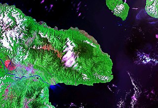
Lae Nadzab Airport Domestic airport in Nadzab, Morobe Province, Papua New Guinea

Lae Nadzab Airport is a regional airport located at Nadzab 42 kilometres (26 mi) outside Lae, Morobe Province, Papua New Guinea along the Highlands Highway. It is served by both private and regional aircraft with domestic flights. The airport replaced the Lae Airfield in 1977.

Finschhafen Place in Morobe Province, Papua New Guinea

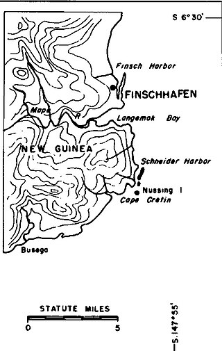
Finschhafen is a town 80 kilometers (50 mi) east of Lae on the Huon Peninsula in Morobe Province of Papua New Guinea. The town is commonly misspelt as Finschafen or Finschaven. During World War II, the town was also referred to as Fitch Haven in the logs of some U.S. Navy men.

Landing at Lae Amphibious landing of World War II

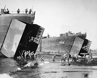
The Landing at Lae was an amphibious landing to the east of Lae and then the subsequent advance on the town during the Salamaua–Lae campaign of World War II. Part of Operation Postern, which was undertaken to capture the Japanese base at Lae, the landing was undertaken between 4 and 6 September 1943 by Australian troops from the 9th Division, supported by US naval forces from the VII Amphibious Force. The first major amphibious operation undertaken by the Australian Army since the failed Gallipoli Campaign, the Australians invested a significant amount of effort into planning the operation.

Nadzab Village is in the Markham Valley, Morobe Province, Papua New Guinea on the Highlands Highway. Administratively, it is located in Gabsongkeg ward of Wampar Rural LLG. The Nadzab Airport is located East of Nadzab Village and was the site of the only Allied paratrooper assault in New Guinea on 5 September 1943.

Lae Airfield

Lae Airfield is a former World War II airfield and later, civilian airport located at Lae, Morobe Province, Papua New Guinea. The airport was closed in the 1980s, in favour of Lae Nadzab Airport, which was able to accommodate larger jet aircraft. The airport was known as Lae Drome or Lae Aerodrome

Tsili Tsili (Tsile-Tsile) Airfield is a former World War II airfield in Morobe Province, Papua New Guinea. The airfield was constructed in secret, behind Japanese lines and played an important role in the allies establishing aerial supremacy ove New Guinea. The airfield was abandoned after the war and today has almost totally returned to its natural state.

Malahang Mission Station, Lae

The Malahang Mission Station is a Lutheran filial station situated in Malahang, Morobe Province in Papua New Guinea now under the auspices of the Evangelical Lutheran Church of Papua New Guinea. The Mission station is located on Busu Road, Malahang opposite the Malahang Industrial Area.

Butibum Suburb in Lae District, Morobe Province, Papua New Guinea

Butibam is a village on the outskirts of Lae, Morobe Province in Papua New Guinea.

Omili is a suburb of Lae in the Morobe Province, Papua New Guinea.

Bumayong is an outer suburb of Lae in the Morobe Province, Papua New Guinea.

Situm Ex-Servicemen Block in Morobe Province, Papua New Guinea

Situm is a government ex-servicemen block outside of Lae in Labuta Rural LLG, Morobe Province, Papua New Guinea.

Voco Point is a suburb of Lae in the Morobe Province, Papua New Guinea. Voco Point is one of the busiest coastal trading points in the country and coastal vessels from throughout the country, from Alotau to Manus, from Lihir to Vanimo line up at the wharves. The passenger boats ferry people to Finschhafen, the Siassi islands, Kimbe, Rabaul, New Ireland, Oro Bay, Alotau, Madang, and Wewak. The local Lae villages call the area around Voco Point Asiawi, which according to mythology, used to be a long point that went out much further but was eaten by the evil spirit Yaayaa.

Chinatown is a suburb of Lae in the Morobe Province, Papua New Guinea.

Bumneng is a suburb of Lae in the Morobe Province, Papua New Guinea.

Eriku is a suburb of Lae in the Morobe Province, Papua New Guinea.

History of Lae

As the township of Lae, in Morobe Province, Papua New Guinea is a relatively new entity, the history of the Lae environs is much older.

ANGAU General Hospital Hospital in Morobe, Papua New Guinea

ANGAU Memorial Hospital is a major hospital in Lae, Papua New Guinea. Named after an Australian Army unit that was responsible for the civil administration of the Territory of Papua and the Mandated Territory of New Guinea, the hospital provides in-patient and specialist medical services to people in the Sepik, Madang and Morobe provinces. In 2013–14, the Australian government announced that it would contribute to the hospital's redevelopment as part of a deal with the PNG government relating to the resettlement of asylum seekers.

The Hopoi Mission Station is a Lutheran filial station situated in Morobe Province in Papua New Guinea now under the auspice of the Evangelical Lutheran Church of Papua New Guinea.

References

  1. Linke, R 2006, The influence of German surveying on the development of New Guinea, Association of Surveyors of PNG. Accessed 25 January 2014.
  2. Short History of the “2" Australian Corps Signals (A I F)
  3. Tesoriero
  4. Simmonds and Smith 1995, Echoes over the Pacific. National Library of Australia ISBN   0 646 24323 3 accessed 31 January 2014
  5. Sinclair, J.P 1998, Golden gateway: Lae & the Province of MorobeCrawford House, ISBN   1863331492, 9781863331494 accessed 31 January 2014
  6. Strahan, L. 2005, Day of Reckoning Pandanus Books, Research School of Pacific and Asian Studies, Australian National University. ISBN   9781740761673
  7. Willis, Ian (1974). Lae, village and city (1. Aufl ed.). Carlton, Vic.: Melbourne University Press. ISBN   0522840760.
  8. The Argus 22 January 1951
  9. The Courier Mail 26 January 1951
  10. Barnes, Victor (May 1999). "Medical Hypnosis in New Guinea" (PDF). Australian Journal of Clinical and Experimental Hypnosis. 27 (1). Retrieved 30 January 2014.
  11. New K85 million tuna facility to open in PNG accessed 29 January 2014
  12. Radford, Anthony J. Singsings, sutures & sorcery. Challenge Books, Melbourne.

Notes

  1. see Mackey and Repatriation Commission [2001] AATA 742, Administrative Appeals Tribunal (Australia)

General coverage of compound - showing native boys leaving for work and variety of work on which they are engaged. N445254 Captain Alexander Morrison Sinclair, as he inspects Royal Papuan Constabulary, native squad. Grave of NX91950 Private Stewart Cruickshanks - 2/31 Infantry Battalion, on left. Grave of 116892 Leading Aircraftman Eric Charles Bertram - RAAF, on right.

Malahang beach is situation about seven miles from Lae, New Guinea and is the recognised beach resort for personnel in the Lae Nadzab area. .