Nadzab

Last updated

Nadzab
Village
1200px Lae village map Papua New Guinea.png
Red pog.svg
Nadzab
Location in the Lae area
Coordinates: 6°32′0″S146°40′0″E / 6.53333°S 146.66667°E / -6.53333; 146.66667
CountryFlag of Papua New Guinea.svg  Papua New Guinea
Province Morobe Province
District Huon District
LLG Wampar LLG
Time zone UTC+10 (AEST)

Nadzab Village is in the Markham Valley, Morobe Province, Papua New Guinea on the Highlands Highway. Administratively, it is located in Gabsongkeg ward of Wampar Rural LLG. [1] [2] The Nadzab Airport is located East of Nadzab Village and was the site of the only Allied paratrooper assault in New Guinea on 5 September 1943.

Contents

Location

Nadzab is located on the Erap River, 5 kilometres (3.1 mi) North of the Markham River and 42.5 kilometres (26.4 mi)42 km North West of Lae. The settlements of Gabmatsung/Gabmatzung and Gabsonkek are located on the East side of the airport. [3]

Grasslands

The present distribution of grasslands in New Guinea is a product of forest clearance and/or burning by man. Lane-Poole (1925), [4] [5] on surveying the forest of the lower Markham Valley near Yalu, hypothesised that;

"At one time forest of this type stretched all the way along the coast between the mountains inland and the sea, and all along the vast valleys of the Markham and Ramu Rivers. Today, artificially formed grasslands have taken the place of the forest on the best of the land, and, in the less fertile areas, a secondary weed growth has established itself"

History

German Colonial

In about 1910 the Gabmatsung/Gabmazung Lutheran mission station was established at Nadzab. [6] and established an airfield for use by small planes until the outbreak of the Pacific War when it became overgrown with dense kunai grass. [7]

The Admission Centre of the 2/4th Australian Field Ambulance Main Dressing Station, 7th Australian Division, formerly the Gabmatzung Lutheran Mission Church. GabmatzungLutheranMissionChurch.JPG
The Admission Centre of the 2/4th Australian Field Ambulance Main Dressing Station, 7th Australian Division, formerly the Gabmatzung Lutheran Mission Church.
Photo of Nadzab airport sign. Village in background Nadzabsign.jpg
Photo of Nadzab airport sign. Village in background

In the 1919 the Melbourne Argus newspaper ran this classified advertisement;

The following items, collected by on Official with the Aid of An Armed Force from Gabmatsung (and other districts) -carved figures, stone clubs, carved plates, bows and arrows, spears, native drum, clubs, horns, modlooms, native pillows, head dresses, bags, shells ornaments and butterflies. JW Styles and Son, Glenhuntly Rd, Caufield [8]

WW2

Between April 1943 and July 1943, the Allied Geographical Section of South West Pacific Area (command) conducted reconnaissance after the Japanese invasion. The Terrain Handbook states at page 18;

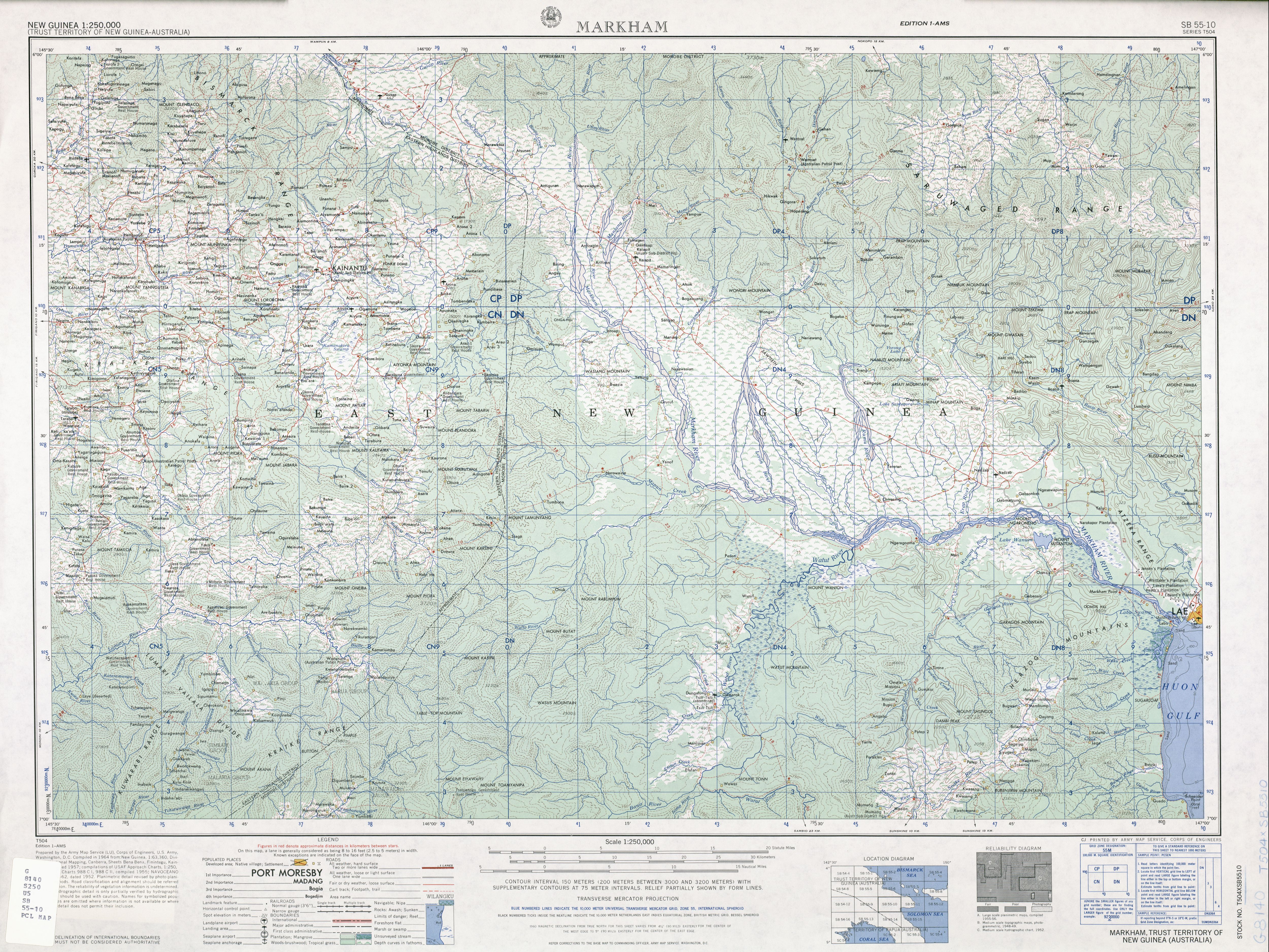
"Nazdab is located twenty-seven miles NW of Lae by road 900 yds by an indefinite width. Covered with Kunai grass. Good dispursal area. Emergency landing ground for heavy freight planes. Extension to 2000 yds thought possible". [9]

The Landing at Nadzab was the first parachute jump for the 503rd Parachute Regiment on 5 September 1943. In conjunction with the Amphibious Landing East of Malahang, it was to be the start of the liberation of Lae from Japanese Occupation. [6]

On 8 September 1943, MACARTHUR'S communique states;

more than 60,000 rounds of ammunition, silencing artillery positions and destroying installations at Gabsonkek (21 miles north-west of Lae), Munum (six miles east of Gabsonkek). Yalu, Nara kapor (14 miles North west of Lae), and Labu Island (60 miles south-west of Lae) [10]

After the landing, the 503rd Headquarters Company established themselves at the Gabonkek village and it was at this time that the descending wildcat logo became their official insignia, until the Battle of Philippines when the insignia was changed to the Rock Patch. [11]

On 19 September 1943 the Gabmatsung Lutheran Mission was converted into the 2/4th Australian Field Ambulance main dressing station for the 7th Australian Division [12]

Cemetery

During WW2, the United States Army established a cemetery used for the duration of the war. All burials were later exhumed and transported to the United States or Manila American Cemetery. [13]

Aerial spraying

In 1992 the Veterans' Review Board (Australia) [lower-alpha 1] heard evidence that chemical DDT aerial spraying and Pyrethrum bombs may have been used in and around Nadzab in November 1944. Number 9 Local Air Supply Unit located at Lae, carried out test air-spraying in an unspecified location in March 1945. The United States Army Air Service units at Nadzab carried out DDT air-spraying experiments locally up to at least November 1944, until about April 1945.

Related Research Articles

Lae is the capital of Morobe Province and is the second-largest city in Papua New Guinea. It is located near the delta of the Markham River and at the start of the Highlands Highway, which is the main land transport corridor between the Highlands Region and the coast. Lae is the largest cargo port of the country and is the industrial hub of Papua New Guinea. The city is known as the Garden City and home of the University of Technology.

<span class="mw-page-title-main">Morobe Province</span> Place in Papua New Guinea

Morobe Province is a province on the northern coast of Papua New Guinea. The provincial capital and largest city is Lae. The province covers 33,705 km2, with a population of 674,810, and since the division of Southern Highlands Province in May 2012 it is the most populous province. It includes the Huon Peninsula, the Markham River, and delta, and coastal territories along the Huon Gulf. The province has nine administrative districts. At least 101 languages are spoken, including Kâte and Yabem language. English and Tok Pisin are common languages in the urban areas, and in some areas pidgin forms of German are mixed with the native language.

The Markham languages form a family of the Huon Gulf languages. It consists of a dozen languages spoken in the Ramu Valley, Markham Valley and associated valley systems in the lowlands of the Madang and Morobe Provinces of Papua New Guinea. Unlike almost other Western Oceanic languages of New Guinea, which are spoken exclusively in coastal areas, many Markham languages are spoken in the mountainous interior of Morobe Province, Papua New Guinea, where they are in heavy contact with Trans-New Guinea languages.

<span class="mw-page-title-main">Lae Nadzab Airport</span> Domestic airport in Nadzab, Morobe Province, Papua New Guinea

Officially named Nadzab Tomodachi International Airport, Nadzab Airport is a regional airport located at Nadzab 42 kilometres (26 mi) outside Lae, Morobe Province, Papua New Guinea along the Highlands Highway. It is served by both private and regional aircraft with domestic flights. The airport replaced the Lae Airfield in 1977.

<span class="mw-page-title-main">Salamaua–Lae campaign</span> 1943 U.S. and Australian offensive during the New Guinea campaign of World War II

The Salamaua–Lae campaign was a series of actions in the New Guinea campaign of World War II. Australian and United States forces sought to capture two major Japanese bases, one in the town of Lae, and another one at Salamaua. The campaign to take the Salamaua and Lae area began after the successful defence of Wau in late January, which was followed up by an Australian advance towards Mubo as the Japanese troops that had attacked Wau withdrew to positions around Mubo. A series of actions followed over the course of several months as the Australian 3rd Division advanced north-east towards Salamaua. After an amphibious landing at Nassau Bay, the Australians were reinforced by a US regimental combat team, which subsequently advanced north up the coast.

<span class="mw-page-title-main">Battle of Kaiapit</span> 1943 engagement in New Guinea

The Battle of Kaiapit was an action fought in 1943 between Australian and Japanese forces in New Guinea during the Markham and Ramu Valley – Finisterre Range campaign of World War II. Following the landings at Nadzab and at Lae, the Allies attempted to exploit their success with an advance into the upper Markham Valley, starting with Kaiapit. The Japanese intended to use Kaiapit to threaten the Allied position at Nadzab, and to create a diversion to allow the Japanese garrison at Lae time to escape.

<span class="mw-page-title-main">Landing at Lae</span> Amphibious landing of World War II

The Landing at Lae was an amphibious landing to the east of Lae and then the subsequent advance on the town during the Salamaua–Lae campaign of World War II. Part of Operation Postern, which was undertaken to capture the Japanese base at Lae, the landing was undertaken between 4 and 6 September 1943 by Australian troops from the 9th Division, supported by US naval forces from the VII Amphibious Force. The first major amphibious operation undertaken by the Australian Army since the failed Gallipoli Campaign, the Australians invested a significant amount of effort into planning the operation.

<span class="mw-page-title-main">Malahang</span> Suburb in Lae District, Morobe Province, Papua New Guinea

Malahang is a suburb of Lae, Morobe Province in Papua New Guinea.

<span class="mw-page-title-main">Landing at Nadzab</span> WWII airborne landing of 1943

The Landing at Nadzab was an airborne landing on 5 September 1943 during the New Guinea campaign of World War II in conjunction with the landing at Lae. The Nadzab action began with a parachute drop at Lae Nadzab Airport, combined with an overland force.

<span class="mw-page-title-main">Lae Airfield</span>

Lae Airfield is a former World War II airfield and later, civilian airport located at Lae, Morobe Province, Papua New Guinea. The airport was closed in the 1980s, in favour of Lae Nadzab Airport, which was able to accommodate larger jet aircraft. The airport was also known as Lae Drome or Lae Aerodrome.

<span class="mw-page-title-main">Malahang Mission Station, Lae</span>

Bumayong is an outer suburb of Lae in the Morobe Province, Papua New Guinea.

<span class="mw-page-title-main">Situm</span> Ex-Servicemen Block in Morobe Province, Papua New Guinea

Situm is a government ex-servicemen block outside of Lae in Labuta Rural LLG, Morobe Province, Papua New Guinea.

Bugandi is a suburb of Lae in the Morobe Province, Papua New Guinea.

<span class="mw-page-title-main">Yalu, Papua New Guinea</span> Village in Morobe Province, Papua New Guinea

Yalu is a large village in Wampar Rural LLG, located in the Markham Valley of Morobe Province, Papua New Guinea. It lies along the Highlands Highway 21.5 kilometres (13.4 mi) north-west of Lae, 7 kilometres (4.3 mi) southeast of Nadzab. The landscape is typically lowland rainforest.

<span class="mw-page-title-main">3 Mile, Lae</span> Suburb in Lae District, Morobe Province, Papua New Guinea

3 Mile is a suburb of Lae in the Morobe Province, Papua New Guinea.

6 Mile is a suburb of Lae in the Morobe Province, Papua New Guinea.

9 Mile is a large village in the Markham Valley of Morobe Province, Papua New Guinea. It lies along the Highlands Highway 9 miles (14 km) from the center of Lae between the foothills of the Atzera Range and the Markham River. The Atzera Range starts at Bugandi and runs adjacent to the Markham River has an elevation of 280 meters above sea level. northwest of Lae, 7 kilometres (4.3 mi) southeast of Nadzab. The landscape is typically lowland rainforest.

<span class="mw-page-title-main">History of Lae</span>

As the township of Lae, in Morobe Province, Papua New Guinea is a relatively new entity, the history of the Lae environs is much older.

Wampar Rural LLG is a local-level government (LLG) located in the Markham Valley of Morobe Province, Papua New Guinea. The Wampar language is spoken in the LLG, along with Labu, Yalu (Aribwaung), Watut, and other Markham languages.

References

  1. United Nations in Papua New Guinea (2018). "Papua New Guinea Village Coordinates Lookup". Humanitarian Data Exchange. 1.31.9.
  2. "Census Figures by Wards – Momase Region". www.nso.gov.pg. 2011 National Population and Housing Census: Ward Population Profile. Port Moresby: National Statistical Office, Papua New Guinea. 2014.
  3. SB 55-10 Markham (5.4 MB). "Series T504, U.S. Army Map Service". Home > Finding Information > PCL Map Collection > New Guinea AMS Topographic Maps. University of Texas at Austin. Retrieved 4 March 2014.
  4. LANE-POOLE, C.E (1925). "The Forest Resources of the Territories of New Guinea and Papua". Australian Parliamentary Paper (73): 361.
  5. Garrett-Jones, Samuel Edward (October 1979). Evidence for changes in Holocene vegetation and lake sedimentation in the Markham Valley, Papua New Guinea (PhD thesis). Australian National University. doi:10.25911/5d7a2a119f250. hdl:1885/47079. ProQuest   28808777.
  6. 1 2 "Nadzab airborne operation". Official Website of the 503d Parachute RCT Association of WWII. Retrieved 28 February 2014.
  7. Malum Nalu (24 April 2009). "Nadzab Airport" . Retrieved 4 March 2014.
  8. 1919 Classified Advertising (18 June 1919). "Classified Advertising". The Argus (Melbourne, Vic1848 – 1957).
  9. Allied Geographical Section-Southwest Pacific Area-Terrain Handbook 4 (No.738). Lae and the Lower Markham Valley28 July "Archived copy" (PDF). Archived from the original (PDF) on 3 February 2014. Retrieved 30 January 2014.{{cite web}}: CS1 maint: archived copy as title (link) accessed 30 January 2014
  10. "Paratroop Landing Closes Ring Round Lae". The Mercury (Hobart) 1860–1954. National Library of Australia. 8 September 1943. Retrieved 4 March 2014.
  11. Bob Flynn & Paul Whitman. "The Cat Patch". 503d Parachute Infantry Regiment Heritage. Retrieved 4 March 2014.
  12. "Nadzab, New Guinea. 1943-09-19. The Admission Centre Of The 2/4th Australian Field Ambulance" . Retrieved 4 March 2014.[ permanent dead link ]
  13. Pacific Wrecks.Com. "Nadzab Morobe Province Papua New Guinea (PNG)" . Retrieved 4 March 2014.

Notes

  1. see Bessie Florence Mcmahon and Repatriation Commission [1992] AATA 241, Administrative Appeals Tribunal (Australia)

6°33′S146°42′E / 6.550°S 146.700°E / -6.550; 146.700