The Titan is a 6,112-foot-elevation (1,863-meter) pillar in Grand County, Utah, United States.

South Mountain is an 11,798-foot (3,596 m) peak in San Juan County, Utah in the United States, about 5 miles (8.0 km) north of La Sal, Utah. It is part of the La Sal Mountains. Precipitation runoff from this mountain drains into tributaries of the Colorado River. The nearest town is Moab, 20 mi (32 km) to the northwest, and the nearest higher neighbor is Mount Tukuhnikivatz, 2.64 mi (4.25 km) to the north.

The East Temple is a prominent 7,709 feet (2,350 m) summit composed of Navajo Sandstone in Zion National Park, in Washington County of southwest Utah, United States. It is one of the notable landmarks in the park. The nearest neighbor is Twin Brothers, one-half mile to the north, and the nearest higher peak is The West Temple, 3.85 miles (6.20 km) to the west-southwest. The mountain is situated 1.8 miles northeast of the park headquarters, at the confluence of Pine Creek and the North Fork Virgin River. This feature's name was applied by John Wesley Powell during his explorations in 1872, and was officially adopted in 1934 by the U.S. Board on Geographic Names. The first ascent was made in 1937 by Glen Dawson, Dick Jones, Homer Fuller, Wayland Gilbert, and Jo Momyer.

Mountain of the Sun is a 6,722-foot (2,049 m) elevation Navajo Sandstone summit located in Zion National Park, in Washington County of southwest Utah, United States. Mountain of the Sun is situated immediately east of Court of the Patriarchs, and south of Zion Lodge, towering 2,500 feet above the lodge and the floor of Zion Canyon. It is set on the east side of the North Fork of the Virgin River which drains precipitation runoff from this mountain. Its neighbors include The Sentinel, Mount Spry, The East Temple, and Mount Moroni. This feature's name was officially adopted in 1934 by the U.S. Board on Geographic Names.
Red Arch Mountain is a 5,930-foot (1,810 m) elevation Navajo Sandstone summit located in Zion National Park, in Washington County of southwest Utah, United States.

Ivins Mountain is a remote 7,019-foot (2,139 m) Navajo Sandstone summit located in Zion National Park, in Washington County of southwest Utah, United States.

The Sundial is a 7,590-foot (2,310-meter) elevation white Navajo Sandstone summit located in Zion National Park, in Washington County of southwest Utah, United States.

Mount Pennell is a prominent 11,413-foot elevation summit located in eastern Garfield County, Utah, United States. Mount Pennell is the second-highest mountain in the Henry Mountains, following Mount Ellen, 10.6 miles to the north. It is situated in a dry, rugged, and sparsely settled region east of Capitol Reef National Park, on primitive land administered by the Bureau of Land Management. Several deep canyons cut the sides of the mountain, which on the higher slopes supports oak, Ponderosa pine, subalpine fir, spruce, Douglas fir, and aspen. Precipitation runoff from this mountain drains into tributaries of the nearby Colorado River.

Mount Holmes is a 7,998-foot elevation summit located in eastern Garfield County, Utah, United States. Mount Holmes is part of the Henry Mountains. It is situated in a dry, rugged, and sparsely settled region west of Glen Canyon National Recreation Area, on primitive land administered by the Bureau of Land Management. Precipitation runoff from this mountain drains into tributaries of the nearby Colorado River, which here is Lake Powell six miles to the east of this mountain.

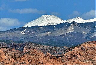
Mount Tukuhnikivatz is a 12,482-foot elevation summit located in San Juan County of Utah, United States. Mount Tukuhnikivatz is the third-highest peak of the La Sal Mountains, and is the premier ski mountaineering destination in the La Sals. It is situated in a dry, rugged, sparsely settled region, and set on land administered by Manti-La Sal National Forest. Precipitation runoff from this mountain drains into tributaries of the Colorado River. The nearest town is Moab, 19 mi (31 km) to the northwest, and the nearest higher neighbor is Mount Peale, 1.7 mi (2.7 km) to the east. The mountain's name is a Native American word that translates as "Where the sun sets last." Locals call it Mount Tuk for short. This mountain has a subsidiary peak unofficially called Little Tuk, approximately one-half mile to the north-northwest.

Mountain of Mystery is a 6,565-foot (2,001 m) Navajo Sandstone summit located in Zion National Park, in Washington County of southwest Utah, United States. Mountain of Mystery is situated above The Narrows, towering over 2,100 feet above the floor of Zion Canyon and the North Fork Virgin River which drains precipitation runoff from this mountain. This peak rises above Orderville Canyon on its north side, and Mystery Canyon on the south. Its neighbors include Mount Majestic, Cathedral Mountain, Observation Point, Cable Mountain, Angels Landing, and The Organ. This feature's name was officially adopted in 1934 by the U.S. Board on Geographic Names. The first ascent via the Northeast Buttress was made 15 September 2001, by Brian Cabe and Tom Jones.
Mount Mellenthin is a 12,645-foot elevation summit located in San Juan County of Utah, United States. Mount Mellenthin is the second-highest peak of the La Sal Mountains, and second-highest in the county. It is situated in a dry, rugged, sparsely settled region, and set on land administered by Manti-La Sal National Forest. Precipitation runoff from this mountain drains into tributaries of the Colorado River. The nearest town is Moab, 20 mi (32 km) to the northwest, and the nearest higher neighbor is Mount Peale, 1.7 mi (2.7 km) to the south. The mountain's name honors Rudolf E. Mellenthin (1884–1918), forest ranger of La Sal National Forest, who was shot to death near this peak on August 23, 1918, while attempting to apprehend two draft evaders. This geographical feature's toponym was officially adopted in 1932 by the U.S. Board on Geographic Names.

Mount Ellsworth is an 8,235-foot elevation summit located in Garfield County, Utah, United States. Mount Ellsworth is part of the Henry Mountains. It is situated in a dry, rugged, and sparsely settled region west of Glen Canyon National Recreation Area, on primitive land administered by the Bureau of Land Management. Precipitation runoff from this mountain drains into tributaries of the nearby Colorado River, which here is Lake Powell eight miles to the east of this mountain.

Pine Valley Peak is a 7,415-foot (2,260 m) mountain located in Zion National Park in Washington County, Utah, United States.

Deertrap Mountain is a 6,837-foot (2,084 m) mountain in Zion National Park in Washington County, Utah, United States.

The Sixshooter Peaks are two iconic sandstone summits located in Bears Ears National Monument in San Juan County, Utah, United States. The larger and higher North Sixshooter Peak rises to an elevation of 6,379 feet, whereas South Sixshooter Peak rises to 6,154 feet, with approximately 1.5 miles (2.4 km) separation between the two. These buttes tower nearly 1,400 feet above the surrounding terrain, and are historic landmarks visible from State Route 211 between Newspaper Rock and the Needles District of Canyonlands National Park. They are situated 1.5 mile outside the boundary of the park, and four miles northwest of Bridger Jack Butte. Variant names for the peaks include "North Six-Shooter Peak", "South Six-shooter Peak", "Six Shooter Peaks", and "Six-shooter Peak". They are so named because of their resemblance to a pair of revolvers pointing skyward.

Window Blind Peak is a 7,030-foot-elevation (2,143-meter) summit located in the San Rafael Swell of Emery County, Utah, U.S. Towering 1,800 feet above its surrounding terrain, it is the highest point of the Mexican Mountain Wilderness Study Area. Ownership is administered by the Bureau of Land Management. It is situated 2.1 miles (3.4 km) southeast of Bottleneck Peak, 1.52 miles (2.45 km) south of Assembly Hall Peak, and the nearest higher neighbor is Cedar Mountain, 8.95 miles (14.40 km) to the north-northeast. Precipitation runoff from this feature drains north into the nearby San Rafael River. The first ascent of this peak was made September 23, 1973, by Jim Langdon, Dale Black, and Dave Palmer via the West Face.

Smithsonian Butte is a 6,780-foot (2,070 m) elevation summit located in the Canaan Mountain Wilderness of Washington County in southwest Utah, United States.

Eagle Crags is a 6,380-foot (1,940 m) elevation summit located in the Canaan Mountain Wilderness of Washington County in southwest Utah, United States.

Assembly Hall Peak is a 6,395-foot-elevation (1,949-meter) summit in Emery County, Utah, United States.