
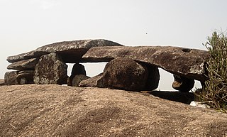
Vizianagaram district is one of the six districts in the Uttarandhra region of the Indian state of Andhra Pradesh with its headquarters located at Vizianagaram. The district was once the part of ancient Kalinga.Saripilli Dibbilingeswara temple, Jayathi Mallikarjuna Temple are the finest examples of ancient Eastern Ganga Dynasty built monuments in the district. The district is bounded on the east by the district of Srikakulam, north by Parvathipuram Manyam south by Visakhapatnam, Anakapalli, southeast by the Bay of Bengal, and west by Alluri Sitharama Raju district. It was formed on 1 June 1979, with some parts carved from the neighbouring districts of Srikakulam and Visakhapatnam. The district is named after the princely state of Vizianagaram. In 2011, it was the least populous district in Andhra Pradesh.

Srikakulam district is one of the twenty-six districts of the Indian state of Andhra Pradesh, located in the Uttarandhra region of the state, with its headquarters located at Srikakulam. It is one of the six districts, located in the extreme northeastern direction of the state. It was formerly known as Chicacole, and was under Ganjam district till 1936 April 1, then merged under Vizagapatam district. Srikakulam district forms the core area of Kalinga where most of its historical capitals like Kalinganagari, pithunda, Dantapuram are located.
Amadalavalasa is a town in Srikakulam district of the Indian state of Andhra Pradesh. It is a municipality and also the mandal headquarters of Amadalavalasa mandal. The town is spread over an area of 19.65 km2 (7.59 sq mi), which is under the jurisdiction of Visakhapatnam Metropolitan Region Development Authority. Srikakulam Road railway station is situated at Amadalavalasa.

Nelli-marla is a census town in Vizianagaram district of the Indian state of Andhra Pradesh. It is in Nellimarla mandal of Vizianagaram revenue division.

The River Nagavali also known as Langulya is one of the main rivers of Southern Odisha and Andhra States in India, between Rushikulya and Godavari basins.

Sangam is a village and a pilgrimage site in Vangara mandal in Srikakulam district in the state of Andhra Pradesh, India. Sangam is a village and a pilgrimage site in Vangara mandal in Srikakulam district in the state of Andhra Pradesh, India.

Gara is a village in Srikakulam district of the Indian state of Andhra Pradesh. It is also the mandal head quarters of Gara Mandal, Srikakulam District, AP.

Hiramandalam is a census town in Srikakulam district of the Indian state of Andhra Pradesh. It is also the mandal headquarters of Hiramandalam mandal in Palakonda revenue division. BRR Project Located at Hiramandalam town. It is located 49 km towards North from District headquarters Srikakulam.
Kotturu is a village in Srikakulam district of the Indian state of Andhra Pradesh. It is located in Kothuru mandal of Palakonda revenue division.

Palakonda is a town in Parvathipuram Manyam district of the Indian state of Andhra Pradesh. It is a nagar panchayat and the mandal headquarters of Palakonda mandal in Palakonda revenue division
Regidi Amadalavalasa is a village in Srikakulam district of the Indian state of Andhra Pradesh. It is located in Regidi Amadalavalasa mandal of Palakonda revenue division.
Sarubujjili is a village in Srikakulam district of the Indian state of Andhra Pradesh. Sarubujjili mandal is bordered by Burja, Seethampeta, Hiramandalam, Jalumuru and Narasannapeta mandals of Srikakulam district.
Dusi is a village and panchayat in Amadalavalasa mandal in Srikakulam district in the Indian state of Andhra Pradesh.
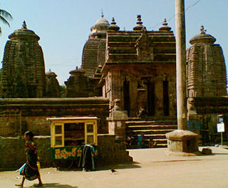
Mukhalingam, also known as Srimukhalingam or Mukhalinga, is a village panchayat in Jalumuru mandal of Srikakulam district in the Indian state of Andhra Pradesh. Historically known as Kalinganagari, Mukhalingam served as the capital of Eastern Ganga Dynasty from 6th century AD to 12th century AD. Emperor Sri Ananthavarma Chodaganga Devara conquered Utkala in 1122 AD and shifted the capital from Kalinganagari to Caudwara kataka
Andra is a village and panchayat in Mentada mandal, Vizianagaram district of Andhra Pradesh, India.

River Vamsadhara or River Banshadhara is an important east flowing river between Rushikulya and Godavari, in Odisha and Andhra Pradesh states in India.
Pedankalam or Peda Ankalam is a village and panchayat in Seethanagaram mandal of Vizianagaram district in Andhra Pradesh, India.
Battili is a town in Bhamini Mandal of Parvathipuram Manyam district in Andhra Pradesh, India.
Thotapalli Barrage is located in Garugubilli Mandal, Parvathipuram Manyam district of Andhra Pradesh State. It was named after the freedom fighter and Political leader Sardar Gouthu Latchanna. The project construction was in between 2003 and 2015. This Project was inaugurated by Andhra Pradesh Chief Minister Nara Chandra babu Naidu on 10 September 2015. The Project provides irrigation to 1,20,000 acres in Srikakulam and Parvathipuram Manyam districts.
Gorle Sriramulu Naidu is an Andhra Pradesh politician and Congress Party leader. He served in Srikakulam politics from 1956 to 1983.
