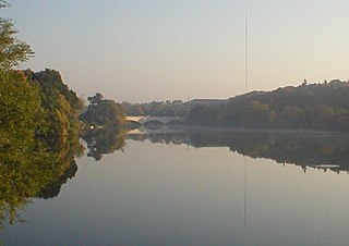
The Otonabee River is a river in Peterborough County in Central Ontario, Canada. The river flows from Katchewanooka Lake, at the north end of the community of Lakefield, through the city of Peterborough to Rice Lake. It is in the Great Lakes Basin and forms part of the Trent-Severn Waterway.

The Municipality of Trent Hills is a township municipality in Northumberland County in Central Ontario, Canada. It is on the Trent River and was created in 2001 through the amalgamation of the municipalities of Campbellford/Seymour, Percy Township and Hastings. Thereafter it was known in brief as Campbellford/Seymour, Percy, Hastings.

The Crowe River is a river in the counties of Haliburton, Hastings, Northumberland and Peterborough in southern Ontario, Canada. It is in the Lake Ontario drainage basin and is a tributary of the Trent River.

Warkworth is a community in the municipality of Trent Hills, Northumberland in Central Ontario, Canada. Originally known as Percy Mills, the village of Warkworth was incorporated in 1857, and became part of Trent Hills when the latter was formed in 2001. Warkworth is named after Warkworth, Northumberland.
Black Lake is a lake in the municipality of Minden Hills, Haliburton County in Central Ontario, Canada. It is part of the Great Lakes Basin and lies within geographic Lutterworth Township.

The Township of Alnwick/Haldimand is a township in central Ontario, Canada, in Northumberland County, situated between Lake Ontario and Rice Lake. It was formed in 2001 by the merger of Alnwick Township in the north and Haldimand Township in the south. Alderville First Nation is an autonomously governed First Nation contained within the township boundaries, in two non-contiguous sections along County Roads 45 and 18.

Jack Lake is a lake and reservoir in the municipalities of Havelock-Belmont-Methuen and North Kawartha, Peterborough County in Central Ontario, Canada, about 100 mi (160 km) directly northeast of Toronto and at the edge of the Canadian Shield in the northeastern portion of the Kawartha lakes region. The lake is in the Great Lakes Basin, and serves as a small headwater pond for the Trent-Severn Waterway. The Dispersed rural community of Jack Lake is on the northwest shore of the lake, reached by Peterborough County Road 52 / Jack Lake Road from the community of Apsley, about 5 kilometres (3.1 mi) to the north on Ontario Highway 28.
Rosedale is a Dispersed Rural Community and unincorporated place located in the city of Kawartha Lakes, Ontario, Canada, 29 kilometres (18 mi) north-west of Lindsay. It is partly in geographic Fenelon Township and partly in Somerville Township, and is on the Rosedale River, part of the Trent–Severn Waterway, where that river drains Balsam Lake on its way to Cameron Lake.
Salem is a Dispersed Rural Community and unincorporated place in the municipal township of Cramahe, Northhumberland County in southern Ontario, Canada. The community is on Northumberland County Road 2 about 4 kilometres (2.5 mi) east of Colborne and 9 kilometres (5.6 mi) west of Brighton.
Anstruther Lake is a lake in the municipality of North Kawartha, Peterborough County in Central Ontario, Canada, between the community of Apsley on Ontario Highway 28 8.5 kilometres (5.3 mi) to the east and the community of Catchacoma on County Road 507 8.5 kilometres (5.3 mi) to the west. Kawartha Highlands Provincial Park encompasses the lake, and the community of Anstruther Lake is on the southern shore. The lake flows out via Anstruther Creek, and the Mississaugua, Otonabee and Trent rivers into Lake Ontario.

Koshlong Lake is a lake in the municipalities of Highlands East and Dysart et al, Haliburton County in Central Ontario, Canada. It is part of the Great Lakes Basin.
Koshlong Creek is a river in geographic Glamorgan Township in the municipality of Highlands East, Haliburton County in Central Ontario, Canada. The river is in the Great Lakes Basin and is a left tributary of the Burnt River.

The Black River is a river in Hastings County in Central Ontario, Canada. It is part of the Great Lakes Basin, and is a left tributary of the Moira River.
Black Lake is a lake in the municipality of Dysart et al, Haliburton County in Central Ontario, Canada. It is part of the Great Lakes Basin and lies within geographic Dysart Township.
The Irondale River is a river in Haliburton County in Central Ontario, Canada. It is part of the Great Lakes Basin, and is a left tributary of the Burnt River.

Bowmanville Creek is a stream in the municipality of Clarington, Regional Municipality of Durham in south-central Ontario, Canada. It flows from the Oak Ridges Moraine to Lake Ontario at Bowmanville. The creek is under the auspices of the Central Lake Ontario Conservation Authority.
Percy Creek is a stream in the municipalities of Trent Hills and Alnwick/Haldimand, Northumberland County, in Central Ontario, Canada. It is in the Great Lakes Basin and is a right tributary of the Trent River. Percy Creek is named after Elizabeth Percy, Duchess of Northumberland.
Percy Creek is a stream in the western part of Sudbury District in Northeastern Ontario, Canada. It is in the Great Lakes Basin and is a right tributary of the Batchawana River.
The Staples River is a river in Kawartha Lakes in Central Ontario, Canada. It is in the Great Lakes Basin and is a tributary of Balsam Lake. The river is 18 kilometres (11 mi) long and has a watershed of 4,792 hectares.
Corben Creek is a stream in the municipality of Minden Hills, Haliburton County, and the unitary city of Kawartha Lakes in Central Ontario, Canada. It is in the Great Lakes Basin and is tributary of Balsam Lake.
