
Bagnolo in Piano is a comune (municipality) in the province of Reggio Emilia in the Italian region Emilia-Romagna, located about 60 kilometres (37 mi) northwest of Bologna and about 8 kilometres (5 mi) northeast of Reggio nell'Emilia.

Baiso is a comune (municipality) in the Province of Reggio Emilia in the Italian region Emilia-Romagna, located about 60 kilometres (37 mi) west of Bologna and about 20 kilometres (12 mi) south of Reggio Emilia.

Bibbiano is a comune (municipality) in the Province of Reggio Emilia in the Italian region Emilia-Romagna, located about 70 kilometres (43 mi) northwest of Bologna and about 14 kilometres (9 mi) southwest of Reggio Emilia.
Boretto is a comune (municipality) in the Province of Reggio Emilia in the Italian region Emilia-Romagna, located about 80 kilometres (50 mi) northwest of Bologna and about 25 kilometres (16 mi) northwest of Reggio Emilia. As of 31 December 2016, it had a population of 5,293 and an area of 19.2 square kilometres (7.4 sq mi).
Campagnola Emilia is a comune (municipality) in the Province of Reggio Emilia in the Italian region Emilia-Romagna, located about 60 kilometres (37 mi) northwest of Bologna and about 20 kilometres (12 mi) northeast of Reggio Emilia.

Campegine is a comune (municipality) in the Province of Reggio Emilia in the Italian region Emilia-Romagna, located about 70 kilometres (43 mi) northwest of Bologna and about 12 kilometres (7 mi) northwest of Reggio Emilia.
Carpineti is a comune (municipality) in the Province of Reggio Emilia in the Italian region Emilia-Romagna, located about 70 kilometres (43 mi) west of Bologna and about 30 kilometres (19 mi) southwest of Reggio Emilia.
Casalgrande is a comune (municipality) in the Province of Reggio Emilia in the Italian region Emilia-Romagna, located about 50 kilometres (31 mi) west of Bologna and about 15 kilometres (9 mi) southeast of Reggio Emilia. As of 8 January 2017, it had a population of 19,215 and an area of 37.7 square kilometres (14.6 sq mi).

Castellarano is a comune (municipality) in the Province of Reggio Emilia in the Italian region Emilia-Romagna, located about 45 kilometres (28 mi) west of Bologna and about 20 kilometres (12 mi) southeast of Reggio Emilia.
Castelnovo di Sotto is a comune (municipality) in the Province of Reggio Emilia in the Italian region Emilia-Romagna, located about 70 kilometres (43 mi) northwest of Bologna and about 14 kilometres (9 mi) northwest of Reggio Emilia.

Fabbrico is a comune (municipality) in the Province of Reggio Emilia in the Italian region Emilia-Romagna, located about 60 kilometres (37 mi) northwest of Bologna and about 25 kilometres (16 mi) northeast of Reggio Emilia.

Gattatico is a comune (municipality) in the Province of Reggio Emilia in the Italian region Emilia-Romagna, located about 80 kilometres (50 mi) northwest of Bologna and about 15 kilometres (9 mi) northwest of Reggio Emilia.

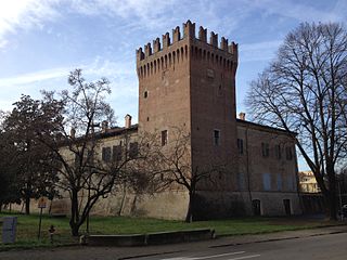
Gualtieri is a comune (municipality) in the Province of Reggio Emilia in the Italian region Emilia-Romagna, located about 70 kilometres (43 mi) northwest of Bologna and about 25 kilometres (16 mi) north of Reggio Emilia on the right bank of the Po River. Historically, it suffered numerous floods, the last occurring in 1951.

Poviglio is a comune (municipality) in the Province of Reggio Emilia in the Italian region Emilia-Romagna, located about 70 kilometres (43 mi) northwest of Bologna and about 20 kilometres (12 mi) northwest of Reggio Emilia.

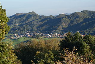
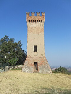
Quattro Castella is a comune (municipality) in the Province of Reggio Emilia in the Italian region Emilia-Romagna, located about 70 kilometres (43 mi) west of Bologna and about 15 kilometres (9 mi) southwest of Reggio Emilia.
Rio Saliceto is a comune (municipality) in the Province of Reggio Emilia in the Italian region Emilia-Romagna, located about 60 kilometres (37 mi) northwest of Bologna and about 20 kilometres (12 mi) northeast of Reggio Emilia.
San Martino in Rio is a comune (municipality) in the Province of Reggio Emilia in the Italian region Emilia-Romagna, located about 50 kilometres (31 mi) northwest of Bologna and about 12 kilometres (7 mi) northeast of Reggio Emilia.
Sant'Ilario d'Enza is a comune (municipality) in the Province of Reggio Emilia in the Italian region Emilia-Romagna, located about 80 kilometres (50 mi) northwest of Bologna and about 15 kilometres (9 mi) northwest of Reggio Emilia.
Toano is a comune (municipality) in the Province of Reggio Emilia in the Italian region Emilia-Romagna, located about 60 kilometres (37 mi) west of Bologna and about 35 kilometres (22 mi) south of Reggio Emilia.

Vezzano sul Crostolo is a comune (municipality) in the Province of Reggio Emilia in the Italian region Emilia-Romagna, located about 60 kilometres (37 mi) west of Bologna and about 13 kilometres (8 mi) southwest of Reggio Emilia.


