
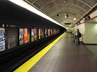
Waterfront is a major intermodal public transportation facility and the main transit terminus in Vancouver, British Columbia, Canada. It is located on West Cordova Street in Downtown Vancouver, between Granville and Seymour Street. The station is also accessible via two other street-level entrances, one on Howe Street to the west for direct access to the Expo Line and another on Granville Street to the south for direct access to the Canada Line.

The Second Narrows Rail Bridge is a vertical-lift railway bridge that crosses the Burrard Inlet and connects Vancouver with the North Shore. The bridge's south end connects directly to the Thornton Tunnel, which connects it to the main Canadian rail network. As the name suggests, it is located at the second narrowing of the Burrard Inlet.

Burrard Inlet is a relatively shallow-sided coastal fjord in southwestern British Columbia, Canada. Formed during the last Ice Age, it separates the City of Vancouver and the rest of the low-lying Burrard Peninsula from the slopes of the North Shore Mountains, home to the communities of West Vancouver and the City and District of North Vancouver.

The Burrard Peninsula is a peninsula in the Lower Mainland region of southwestern British Columbia, Canada, lying between Burrard Inlet to the north and the Fraser River to the south, and bounded by Georgia Strait on the west and the Pitt River on the east. The City of Vancouver occupies most of the western half of the peninsula.

False Creek is a short inlet in the heart of Vancouver. It separates downtown from the rest of the city. It was named by George Henry Richards during his Hydrographic survey of 1856-63. While traveling along the south side of the Burrard Inlet, he thought he was traversing a creek; upon discovering his error, he gave the waterway its modern name.

Canada Place is a building situated on the Burrard Inlet waterfront of Vancouver, British Columbia. It is the home of the Vancouver Convention Centre, the Pan Pacific Vancouver Hotel, Vancouver's World Trade Centre, and the virtual flight ride FlyOver Canada. The building's exterior is covered by fabric roofs resembling sails. It is also the main cruise ship passenger terminal for the region, where cruises to Alaska originate. The building was designed by architects Zeidler Roberts Partnership in joint venture with Musson Cattell Mackey Partnership and DA Architects + Planners.
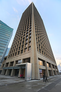
Granville Square is a prominent tower located at 200 Granville Street in Downtown Vancouver's Financial District. Completed in 1973, the building stands at 138.4 metres tall. The tower and its plaza are located atop the tracks of the Canadian Pacific Railway, and adjacent to Waterfront Station.
The Dunsmuir Tunnel is a subway tunnel below Dunsmuir Street in Vancouver, British Columbia, Canada. The tunnel is used by the Expo Line of Metro Vancouver's SkyTrain rapid transit system. It is located downtown and has Burrard and Granville stations built within the tunnel. The western tunnel portal is located midway between Waterfront and Burrard stations, while the eastern portal is adjacent to Stadium–Chinatown station.
The Port of Vancouver was the name of the largest port in Canada, the largest in the Pacific Northwest, and the largest port on the West Coast of North America by metric tons of total cargo, with 76.5 million metric tons. The port amalgamated with the Fraser River Port Authority and the North Fraser Port Authority in 2008 to form Port Metro Vancouver.

The history of Vancouver is one that extends back thousands of years, with its first inhabitants arriving in the area following the Last Glacial Period. Vancouver is situated in British Columbia, Canada; with its location near the mouth of the Fraser River and on the waterways of the Strait of Georgia, Howe Sound, Burrard Inlet, and their tributaries. Vancouver has, for thousands of years, been a place of meeting, trade, and settlement.

Fairview is a neighbourhood on the west side of the city of Vancouver, British Columbia, Canada. It runs from 16th Avenue in the south, to Burrard Street in the west, to Cambie Street in the east, and to False Creek in the north.
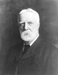
Henry John Cambie was a Canadian surveyor, civil engineer, and a notable figure in the completion of that country's transcontinental railway. He was also a notable pioneer resident of Vancouver.
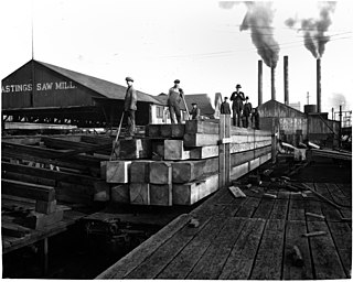
Hastings Mill was a sawmill on the south shore of Burrard Inlet and was the first commercial operation around which the settlement that would become Vancouver developed in British Columbia, Canada. Founded in 1865 by Edward Stamp, the sawmill operated until its closure in 1928.

Victoria Harbour is a harbour, seaport, and seaplane airport in the Canadian city of Victoria, British Columbia. It serves as a cruise ship and ferry destination for tourists and visitors to the city and Vancouver Island. It is both a port of entry and an airport of entry for general aviation. Historically it was a shipbuilding and commercial fishing centre. While the Inner Harbour is fully within the City of Victoria, separating the city's downtown on its east side from the Victoria West neighbourhood, the Upper Harbour serves as the boundary between the City of Victoria and the district municipality of Esquimalt. The inner reaches are also bordered by the district of Saanich and the town of View Royal. Victoria is a federal "public harbour" as defined by Transport Canada. Several port facilities in the harbour are overseen and developed by the Greater Victoria Harbour Authority, however the harbour master's position is with Transport Canada.

The Great Vancouver Fire was a conflagration that destroyed most of the newly incorporated city of Vancouver, British Columbia, Canada on June 13, 1886. It started as two land clearing fires to the west of the city. The first fire was further away from the city and was clearing land for the roundhouse of the terminus of the Canadian Pacific Railway. The second fire was clearing land to extend the city to the west. The Great Fire occurred shortly after the township of Granville was incorporated into the City of Vancouver.
The Canadian Pacific Railway is a Canadian Class I railway that stretches from Montreal, Quebec, to Vancouver, British Columbia. The British Columbia (BC) portion of the railway was constructed between 1881 and 1885, fulfilling a promise extended to BC when it entered Confederation in 1871. For decades, it was the only practical means of long–distance passenger transport in Canada.
This is a timeline of the history of Vancouver.
Ballantyne Pier is a commercial and passenger dock of the Port of Vancouver, Canada, located at 851 Centennial Road. It sits at the west side of Rogers Sugar across the Canadian Pacific Railway tracks from Powell Street. Passenger terminal access is via Clark Drive or McGill Street Overpass only.

Centerm is short for Centennial Terminals, a major dock in Vancouver's East Side. With the conversion to containerization and modular transport, the open pallet transport of goods that had prevailed on the waterfront was over. As such larger, newer facilities were needed by the late 1960s. With the shipping rules changed in 1968, container cranes and flat wharf space became paramount.

The Canadian Pacific Railway embarked on a series of expansions in the years 1910-15. These included new railway equipment, ships, yards and the Second Hotel Vancouver. With the CPR expanding its Canadian Pacific Navigation Company, and it fleets running both Coastally—to Seattle, Victoria, BC and Alaska—and Internationally—to Japan, China, and Hong Kong; the CPR needed more wharf space in Vancouver harbour.
