Cabo de Hornos National Park

Last updated
Cabo de Hornos National Park
CapeHorn ASTER 2005sep20.jpg
Satellite image of Hermite Islands
Relief Map of Chile.jpg
Red pog.svg
Location Tierra del Fuego, Chile
Nearest city Puerto Williams
Coordinates 55°49′59″S67°25′59″W / 55.833°S 67.433°W / -55.833; -67.433
Area63,093 ha (155,906 acres) [1]
EstablishedApril 26, 1945 (1945-04-26) [2]
Visitors10,407 [3] (in 2016)
Governing body Corporación Nacional Forestal

Cabo de Hornos National Park is a protected area in southern Chile that was designated a Biosphere Reserve by UNESCO in 2005, [4] along with Alberto de Agostini National Park. The world's southernmost national park, [5] it is located 12 hours by boat from Puerto Williams in the Cape Horn Archipelago, which belongs to the Commune of Cabo de Hornos in the Antártica Chilena Province of Magallanes y Antártica Chilena Region.

Contents

The park was created in 1945 [2] and includes the Wollaston Islands and the Hermite Islands. It covers 63,093 hectares (155,906 acres) [1] and is run by the Corporacion Nacional Forestal (CONAF), the Chilean body that governs all national parks in Chile. [6]

Origins

The region of Cabo de Hornos (Cape Horn) was discovered by the Dutch merchant Isaac Le Maire on January 29, 1616, and was named Hoorn after the Dutch city where the expedition came from. The national park was created on April 26, 1945, by the Chilean Ministry of Agriculture. [2]

Geography

The park covers an area of 63,093 hectares (155,906 acres), [1] at a general altitude of 220 meters, with the exception of two major peaks: Cerro Pirámide, which has an altitude of 406 meters, and Cerro Hyde, the highest point with an altitude of 670 meters. It comprises a series of the islands and islets that make up the archipelago, including the main landmasses of the Wollaston and Hermite Islands.The park is the southernmost piece of Chilean territory, except for the Chilean Antarctic Territory which is in dispute. [7]

Climate

The climate in the park is generally cool, owing to the southern latitude. There are no clearly distinct weather stations, but a study in 1882–1883 found an annual rainfall of 1,357 millimetres (53.4 in), with an average annual temperature of 5.2 °C (41.4 °F). Winds were reported to average 30 kilometres per hour (8.33 m/s; 18.64 mph), (5  Bf), with squalls of over 100 kilometres per hour (27.78 m/s; 62.14 mph), (10 Bf) occurring in all seasons. [8] There are 278 days of rainfall (70 days of snow) and 2000 mm of annual rainfall [9]

Cloud coverage is generally extensive, with averages from 5.2 eighths in May and July to 6.4 eighths in December and January. [10] [ unreliable source? ] Precipitation is high throughout the year: the weather station on the nearby Diego Ramirez Islands, 109 kilometres (68 miles) south-west in the Drake Passage, shows the greatest rainfall in March, averaging 137.4 millimetres (5.41 in); while October, which has the least rainfall, still averages 93.7 millimetres (3.69 in). [11] [ unreliable source? ] Wind conditions are generally severe, particularly in winter. In summer, the wind at Cape Horn is gale force up to 5% of the time, with generally good visibility; however, in winter, gale-force winds occur up to 30% of the time, often with poor visibility. [12]

Flora

The terrain is almost entirely treeless peat and its main characteristic is the presence of tuberous vegetable formations covered in low dense Poaceaes (Gramineae), lichen and mosses that are resistant to the low temperatures and harsh weather. In some parts, small wooded areas of Antarctic beech or nire, lenga, winter's bark or canelo, and Magellanic coigüe can be found. [13]

Fauna

As with the flora, fauna in the park is scarce and many of the species are endangered. The fauna is dominated by birds and maritime mammals. [14] Bird species found on the islands include: [15] Magellanic penguin (Spheniscus magellanicus), or red peek penguin, the southern giant petrel (Macronectes giganteus), kelp gull or Dominican gull (Larus dominicanus), red-legged cormorant ( Poikilocarbo gaimardi , also known as the red-legged shag, red-footed cormorant, red-footed shag, Gaimard's cormorant or grey cormorant), [16] and southern royal albatross (Diomedea epomophora). [17]

Mammal species found in the park include: marine otter (Lontra felina, known locally as chungungo), leopard seal (Hydrurga leptonyx), Chilean dolphin (Cephalorhynchus eutropia, also known as the black dolphin or tonina), Burmeister's porpoise (Phocoena spinipinnis), Peale's dolphin (Lagenorhynchus australis) and humpback whale (Megaptera novaeangliae).

See also

Related Research Articles

<span class="mw-page-title-main">Leopard seal</span> Macropredatory species of Antarctic seal

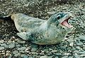
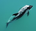
The leopard seal, also referred to as the sea leopard, is the second largest species of seal in the Antarctic. Its only natural predator is the orca. It feeds on a wide range of prey including cephalopods, other pinnipeds, krill, fish, and birds, particularly penguins. It is the only species in the genus Hydrurga. Its closest relatives are the Ross seal, the crabeater seal and the Weddell seal, which together are known as the tribe of Lobodontini seals. The name hydrurga means "water worker" and leptonyx is the Greek for "thin-clawed".

<span class="mw-page-title-main">Puerto Williams</span> City in Magallanes y Antártica Chilena Region, Chile

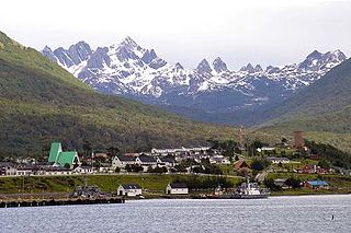
Puerto Williams is a city, port and naval base on Navarino Island in Chile, and is also the southernmost peopled settlement in the world. It faces the Beagle Channel. It is the capital of the Chilean Antarctic Province, one of four provinces in the Magellan and Chilean Antarctica Region, and administers the communes of Chilean Antarctic Territory and Cabo de Hornos. It has a population of 2,874, including both naval personnel and civilians. Puerto Williams claims the title of world's southernmost city. The settlement was founded in 1953, and was first named Puerto Luisa. The town was later named after John Williams Wilson, a British man who founded Fuerte Bulnes, the first settlement in the Strait of Magellan. It has served primarily as a naval base for Chile. The Chilean Navy runs the Guardiamarina Zañartu Airport and hospital, as well as nearby meteorological stations. Since the late 20th century, the number of navy personnel has decreased in Puerto Williams and the civilian population has increased. In that period, tourism and support of scientific research have contributed to an increase in economic activity.

<span class="mw-page-title-main">Beagle Channel</span> Strait in Tierra del Fuego

Beagle Channel is a strait in the Tierra del Fuego Archipelago, on the extreme southern tip of South America between Chile and Argentina. The channel separates the larger main island of Isla Grande de Tierra del Fuego from various smaller islands including the islands of Picton, Lennox and Nueva; Navarino; Hoste; Londonderry; and Stewart. The channel's eastern area forms part of the border between Chile and Argentina and the western area is entirely within Chile.

<span class="mw-page-title-main">Antártica Chilena Province</span> Province in Magallanes y Antártica Chilena, Chile

Antártica Chilena Province is the southernmost of the four provinces in Chile's southernmost region, Magallanes and Antártica Chilena Region (XII). The capital is Puerto Williams. The province comprises the extreme southern part of Isla Grande de Tierra del Fuego, the islands south and west of Isla Grande, and Chile's claims in Antarctica. The province is administratively divided into two communes (comunas): Cabo de Hornos, located at the southern tip of South America, and Antártica, a wedge-shaped claim of Antarctica, which is not internationally recognized. Its total area of 1,265,853.7 km2 (488,749 sq mi) makes it almost twice as large as all other provinces of Chile combined.

<span class="mw-page-title-main">Ildefonso Islands</span>

Islas Ildefonso are a group of islands in Chile. The islands belong to the Commune of Cabo de Hornos in Antártica Chilena Province of Magallanes and Antártica Chilena Region. They lie 96 km (60 mi) west of Isla Hermite, part of Tierra del Fuego, and 93 km (58 mi) NNW of Diego Ramirez Islands, but only 27 km (17 mi) south of Isla Hoste or 23 km (14 mi) to rocks near Isla Hoste.

<span class="mw-page-title-main">Cape Horn</span> Headland of the Tierra del Fuego archipelago located in Chile

Cape Horn is the southernmost headland of the Tierra del Fuego archipelago of southern Chile, and is located on the small Hornos Island. Although not the most southerly point of South America, Cape Horn marks the northern boundary of the Drake Passage and marks where the Atlantic and Pacific Oceans meet.

<span class="mw-page-title-main">Alberto de Agostini National Park</span>

Alberto de Agostini National Park is a protected area that was created on January 22, 1965, on land that was formerly part of the "Hollanda" forest reserve and "Hernando de Magallanes National Park". It covers 1,460,000 hectares and includes the Cordillera Darwin mountain range, which is the final land-based stretch of the Andes before it becomes a chain of mountains appearing as small islands that sink into the Pacific Ocean and the Beagle Channel.

<span class="mw-page-title-main">Archipiélago de Juan Fernández National Park</span>

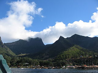
Archipiélago de Juan Fernández National Park is a national park located in the Pacific Ocean 665 kilometres west of Chile's mainland port of San Antonio, in the Juan Fernández Archipelago. The park covers 96 square kilometres and comprises the Santa Clara, Alejandro Selkirk and the most part of the Robinson Crusoe Island islands.

<span class="mw-page-title-main">Hornos Island</span> Subantarctic island of Chile, known for Cape Horn

Hornos Island is a Chilean island at the southern tip of South America. The island is mostly known for being the location of Cape Horn. It is generally considered South America's southernmost island, but the Diego Ramírez Islands are farther south. The island is one of the Hermite Islands, part of the Tierra del Fuego archipelago.

<span class="mw-page-title-main">Cabo de Hornos, Chile</span> Commune in Magallanes y Antártica Chilena, Chile

Cabo de Hornos is a Chilean commune located in the south of Tierra del Fuego archipelago, in Antártica Province, Magallanes Region. The municipality of Cabo de Hornos, located in the town of Puerto Williams, also administers the Antártica commune. It is named for Cabo de Hornos, or "Cape Horn", the southern tip of South America.

<span class="mw-page-title-main">Pingüino de Humboldt National Reserve</span>

Pingüino de Humboldt National Reserve is a nature reserve located a short distance off the coast of mainland Chile. It consists of three islands: Chañaral, Damas, and Choros. It is located about 100 km (62 mi) north of La Serena in the Coquimbo Region of Chile and has a total area of 859.3 hectares. Coastal communities of Caleta Chañaral, Chañaral de Aceituno, and Punta de Choros are nearby. The reserve is an important breeding site for the Humboldt penguin, for which it is named, and is a habitat for sea lions and bottlenose dolphins, chungungos, sea turtle, whale, albatross and cormorant. Aside from dolphins, local cetacean diversity includes migratory rorquals such as blue, fin, and humpback whales, and sperm whales.

<span class="mw-page-title-main">Southern Indian Ocean Islands tundra</span> Ecoregion of several subantarctic islands in the southern Indian Ocean

The Southern Indian Ocean Islands tundra is a tundra ecoregion that includes several subantarctic islands in the southern Indian Ocean.

The Cape Horn Biosphere Reserve is located in the extreme south of Chile and comprises marine areas, islands, fjords, channels, forests and moorland. It covers an area of approximately 49,000 km2 (19,000 sq mi). All biosphere reserves include core zones, buffer zones and transition zones. In the case of Cape Horn Biosphere Reserve, the core zone is constituted of Alberto de Agostini National Park and Cabo de Hornos National Park, which are strictly protected under Chilean law and under the biosphere reserve status cannot have infrastructure for lodging.

<span class="mw-page-title-main">Wildlife of Chile</span>

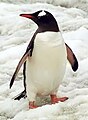
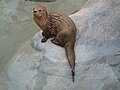
The wildlife of Chile is very diverse because of the country's slender and elongated shape, which spans a wide range of latitude, and altitude, ranging from the windswept coastline of the Pacific coast on the west to northern Andes to the sub-Antarctic, high Andes mountains in the east. There are many distinct ecosystems.

Cape Horn is the southernmost headland of Hornos Island at the Drake Passage, sometimes erroneously known as the southernmost point of South America.

References

  1. 1 2 3 "National Parks of Chile". CONAF. Retrieved 2 April 2017.
  2. 1 2 3 "Cabo de Hornos National Park". CONAF. Retrieved 2 April 2017.
  3. "Visitor Statistics" (PDF). National Forest Corporation (Chile). 31 January 2017. p. 3. Retrieved 2 April 2017.
  4. Cabo de Hornos UNESFO UNESCO 2009 - 2014, retrieved on December 16, 2014
  5. Cape Horn The Encyclopedia of Earth 2014, retrieved on December 16, 2014
  6. "Parque Nacional Cabo de Hornos". Corporacion Nacional Forestal. Archived from the original on 2012-08-07. Retrieved 2012-03-20.
  7. "Frozen empires : a history of the Antarctic sovereignty dispute between Britain, Argentina, and Chile, 1939-1959" Digital Repository, University of Texas 2005 - 2008, retrieved on December 15, 2014
  8. Opiliones from the Cape Horn Archipelago Archived 2007-09-30 at the Wayback Machine , James C. Cokendolpher and Dolly Lanfranco L.; from Texas Tech University, 1985. Retrieved February 5, 2006.
  9. Rescate en el Cabo de Hornos Archived 2014-11-14 at the Wayback Machine , REPORTAJE HISTÓRICO: RESCATE EN EL CABO DE HORNOS, retrieved on December 15, 2014
  10. Usuaia: Monthly Normals Archived 2018-11-06 at the Wayback Machine , from Weather Underground. Retrieved February 5, 2006.
  11. Isla Diego Ramirez: Monthly Normals Archived 2018-11-06 at the Wayback Machine , from Weather Underground. Retrieved February 5, 2006.
  12. U.S. Navy Marine Climatic Atlas of the World: Rounding Cape Horn, 1995. Retrieved February 5, 2006.
  13. Cabo de Hornos National Park Archived 2014-12-21 at the Wayback Machine 2012 Tourismchile.com retrieved on December 14, 2014
  14. La Patagonia: Especies en peligro (es) Archived 2014-12-21 at the Wayback Machine oceana.org 2014, Retrieved on December 16, 2014
  15. Cape Horn Biosphere Reserve Archived 2014-10-22 at the Wayback Machine A Challenge for Biodiversity Conservation, and Implementation of Sustainable Development in Southernmost South America, Ricardo Rozzi, Francisca Massardo, Andrés Mansilla, Christopher B. Anderson, Augustin Berghöfer, Miguel Mansilla, María Rosa Gallardo, Jordi Plana, Uta Berghöfer, Ximena Arango, Shaun Russell, Pedro Araya & Eduardo Barros
  16. Nelson, J. B. 2005. Cormorants and shags. Pages 512–14. In C. M. Perrins, W. J. Bock and J. Kikkawa, eds. Pelicans, Cormorants, and their Relatives. Oxford University Press, New York.
  17. Albatros real, pajaro carnero rutaschile.com 2014, Retrieved on December 16, 2014