
Tierra del Fuego is an archipelago off the southernmost tip of the South American mainland, across the Strait of Magellan.

The Strait of Magellan, also called the Straits of Magellan, is a navigable sea route in southern Chile separating mainland South America to the north and Tierra del Fuego to the south. The strait is considered the most important natural passage between the Atlantic and Pacific oceans. The strait is approximately 570 km long and 2 km wide at its narrowest point. In 1520, the Spanish expedition of the Portuguese navigator Ferdinand Magellan, after whom the strait is named, became the first Europeans to discover it.
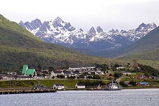
Puerto Williams is a city, port and naval base on Navarino Island in Chile, and is also the southernmost populated settlement in the world. It faces the Beagle Channel. It is the capital of the Chilean Antarctic Province, one of four provinces in the Magellan and Chilean Antarctica Region, and administers the communes of Chilean Antarctic Territory and Cabo de Hornos. It has a population of 2,874, including both naval personnel and civilians. Puerto Williams claims the title of world's southernmost city. The settlement was founded in 1953, and was first named Puerto Luisa. The town was later named after John Williams Wilson, a British man who founded Fuerte Bulnes, the first settlement in the Strait of Magellan. It has served primarily as a naval base for Chile. The Chilean Navy runs the Guardiamarina Zañartu Airport and hospital, as well as nearby meteorological stations. Since the late 20th century, the number of navy personnel has decreased in Puerto Williams and the civilian population has increased. In that period, tourism and support of scientific research have contributed to an increase in economic activity.

Beagle Channel is a strait in the Tierra del Fuego Archipelago, on the extreme southern tip of South America between Chile and Argentina. The channel separates the larger main island of Isla Grande de Tierra del Fuego from various smaller islands including the islands of Picton, Lennox and Nueva; Navarino; Hoste; Londonderry; and Stewart. The channel's eastern area forms part of the border between Chile and Argentina and the western area is entirely within Chile.

Antártica Chilena Province is the southernmost of the four provinces in Chile's southernmost region, Magallanes and Antártica Chilena Region (XII). The capital is Puerto Williams. The province comprises the extreme southern part of Isla Grande de Tierra del Fuego, the islands south and west of Isla Grande, and Chile's claims in Antarctica. The province is administratively divided into two communes (comunas): Cabo de Hornos, located at the southern tip of South America, and Antártica, a wedge-shaped claim of Antarctica, which is not internationally recognized. Its total area of 1,265,853.7 km2 (488,749 sq mi) makes it almost twice as large as all other provinces of Chile combined.

Hoste Island is one of the southernmost islands in Chile, lying south, across the Beagle Channel, from Isla Grande de Tierra del Fuego and west of Navarino Island, from which it is separated by the Murray Channel. It is named after William Hoste, one of Lord Nelson's protégés.

Picton, Lennox and Nueva form a group of three islands at the extreme southern tip of South America, in the Chilean commune of Cabo de Hornos in Antártica Chilena Province, Magallanes and Antártica Chilena Region. Located in the Tierra del Fuego archipelago, they lie east of Navarino Island and are separated from the Argentine part of Isla Grande in the north by the Beagle Channel. They have an area of 170.4 km2 (Lennox), 105.4 km2 (Picton), 120.0 km2 (Nueva).

The Yahgan are a group of indigenous peoples in the Southern Cone of South America. Their traditional territory includes the islands south of Isla Grande de Tierra del Fuego, extending their presence into Cape Horn, making them the world's southernmost indigenous human population.

False Cape Horn or Falso Cabo de Hornos is a headland at the south end of Hoste Island, 35 statute miles (56 km) northwest of Cape Horn, located at 55°43′37″S68°03′16″W. False Cape Horn is the southernmost point of the large islands of the Tierra del Fuego group, located close to the mainland of South America.

Cape Horn is the southernmost headland of the Tierra del Fuego archipelago of southern Chile, and is located on the small Hornos Island. Although not the most southerly point of South America, Cape Horn marks the northern boundary of the Drake Passage and marks where the Atlantic and Pacific Oceans meet.

The Hermite Islands are the islands Hermite, Herschel, Deceit and Hornos as well as the islets Maxwell, Jerdán, Arrecife, Chanticleer, Hall, Deceit (islet), and Hasse at almost the southernmost end of South America. The smallest and southernmost of the major islands is Hornos Island, the location of Cape Horn. The islands are located south of the Wollaston Islands and separated from them by the Franklin Channel. The islets Terhalten, Sesambre, Evout and Barnevelt are located easterly and are not considered part of the Hermite islands.

Navarino Island is a large Chilean island, with an area of 2,514 km2 (971 sq mi) and a coastline of 510 km (320 mi). It is located between Isla Grande de Tierra del Fuego, to the north, and Cape Horn, to the south. The island forms part of the Commune of Cabo de Hornos, the southernmost commune in Chile and in the world, belonging to Antártica Chilena Province in the XII Region of Magallanes and Chilean Antarctica. Its population is concentrated primarily in the communal capital, Puerto Williams, and in small settlements like Puerto Navarino, Río Guanaco and Puerto Toro. The highest point of the island is Pico Navarino at 1,195 m (3,921 ft). The island is a popular destination for fly-fishers.

Cabo de Hornos National Park is a protected area in southern Chile that was designated a Biosphere Reserve by UNESCO in 2005, along with Alberto de Agostini National Park. The world's southernmost national park, it is located 12 hours by boat from Puerto Williams in the Cape Horn Archipelago, which belongs to the Commune of Cabo de Hornos in the Antártica Chilena Province of Magallanes y Antártica Chilena Region.
The Murray Channel is a channel of Chile located in the Commune of Cabo de Hornos, in the Antártica Chilena Province of the Magallanes y la Antártica Chilena Region. It separates Hoste Island from Navarino Island and is bounded by the Beagle Channel to the north. The salinity of the Murray Channel is approximately 31.8 parts per thousand.
The region of the Beagle Channel, explored by Robert FitzRoy in the 1830s, was one of the last to be colonized by Chile and Argentina. The cold weather, the long distances from other inhabited regions, and the shortage of transport and subsistence, kept it far from the governmental task.
Cabo de Hornos is a Chilean commune located in the south of Tierra del Fuego archipelago, in Antártica Province, Magallanes Region. The municipality of Cabo de Hornos, located in the town of Puerto Williams, also administers the Antártica commune. It is named for Cabo de Hornos, or "Cape Horn", the southern tip of South America.
The Cape Horn Biosphere Reserve is located in the extreme south of Chile and comprises marine areas, islands, fjords, channels, forests and moorland. It covers an area of approximately 49,000 km2 (19,000 sq mi). All biosphere reserves include core zones, buffer zones and transition zones. In the case of Cape Horn Biosphere Reserve, the core zone is constituted of Alberto de Agostini National Park and Cabo de Hornos National Park, which are strictly protected under Chilean law and under the biosphere reserve status cannot have infrastructure for lodging.

Bahia Wulaia is a bay on the western shore of Isla Navarino along the Murray Channel in extreme southern Chile. The island and adjacent strait are part of the commune of Cabo de Hornos in the Antártica Chilena Province, which is part of the Magallanes and Antartica Chilena Region.

Herschel Island is an island belonging to Chile. The island is located just north of the Drake Passage and southeast of Tierra del Fuego. It is part of the Hermite Islands. The Franklin Channel on the north side of the island separates Herschel from the southernmost Wollaston Islands. Herschel Island is part of the Cabo de Hornos National Park.


