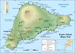
Rapa Nui National Park

Last updated
Rapa Nui National Park
Ahu-Akivi-1.JPG
Ahu Akivi moai that face the ocean
Location Easter Island, Chile
Nearest city Hanga Roa
Area6,800 hectares (17,000 acres)
Established1935
Visitors52,202 [1] (in 2012)
Governing bodyMa'u Henua Indigenous Community [2]
TypeCultural
Criteriai, iii, v
Designated1995 (19th session)
Reference no. 715
Region Latin America and the Caribbean

Rapa Nui National Park (Spanish : Parque nacional Rapa Nui) is a national park and UNESCO World Heritage Site located on Easter Island, Chile. Rapa Nui is the Polynesian name of Easter Island; its Spanish name is Isla de Pascua. The island is located in the southeastern Pacific Ocean, at the southeastern extremity of the Polynesian Triangle. The island was taken over by Chile in 1888. Its fame and World Heritage status arise from the 887 extant stone statues known by the name "moai", whose creation is attributed to the early Rapa Nui people who inhabited the island starting between 300 and 1200 AD. Much of the island has been declared as Rapa Nui National Park which, on 22 March 1996, UNESCO designated a World Heritage Site under cultural criteria (i), (iii), & (v). Rapa Nui National Park is now under the administrative control of the Ma´u Henua Polynesian Indigenous Community, which is the first autonomous institute on the island. The indigenous Rapa Nui people have regained authority over their ancestral lands and are in charge of the management, preservation and protection of their patrimony. On the first of December 2017, the ex-President Michelle Bachelet returned ancestral lands in the form of the Rapa Nui National Park to the indigenous people. For the first time in history, the revenue generated by the National Park is invested in the island and used to conserve the natural heritage.

Contents

Geography

Rapa Nui, showing the three main volcanoes Terevaka, Poike, Rano Kau, as well as Anakena beach, the islets including Motu Nui. Modern Hanga Roa and Mataveri International Airport, the ruins at Orongo and the quarry at Rano Raraku. It marks major ahus with moai. Easter Island map-en.svg
Rapa Nui, showing the three main volcanoes Terevaka, Poike, Rano Kau, as well as Anakena beach, the islets including Motu Nui. Modern Hanga Roa and Mataveri International Airport, the ruins at Orongo and the quarry at Rano Raraku. It marks major ahus with moai.

Geographically isolated, the island forms the eastern geographic and cultural boundary of Polynesia. [3] It is 3,700 kilometres (2,300 mi) west of Chile, about 2,200 km (1,400 mi) east of Pitcairn Island (the nearest human habitat) [4] and is the most remote inhabited spot on Earth. [3] The park is triangular in shape and has a length of 23 km (14 mi) and a width of 11 km (6.8 mi). [3] It is home to an extinct megalithic culture which is seen in the form of edifices of huge statues called "moai" made out of volcanic rocks. The topography includes volcanoes and a rugged coastline. [5] Its elevation varies from sea level to 300 m (980 ft). It has fresh water lakes, volcanic craters and a coastline which is subject to erosion.

Climate

The park experiences a warm sub-tropical climate [5] with southeast trade winds from October to April. The annual average rainfall is 1,250 millimetres (49 in), with rains occurring during the winter season. The average temperature varies from 19 °C (66 °F) in winter to 24 °C (75 °F) in summer. [3]

History

Moai at Rano Raraku, Easter Island. Moai Rano raraku.jpg
Moai at Rano Raraku, Easter Island.
Restored stone houses at Orongo Orongohaeuser.jpg
Restored stone houses at Orongo

The Rapa Nui people settled the island some time between 300 and 1200 CE. The park was created by the Chilean Government in 1935. The native people were confined to a reserve area just outside the capital city of Hanga Roa and the rest of the land was leased to sheep ranchers. The movement for independence was started in 1964 and following this the lease for sheep farming was terminated during the 1980s and the entire island was declared a historic park. The population of the island which was 2,770 in 1972 rose to 3,792 by 2002, mostly concentrated in the capital. [6]

The island was brought under the administrative control of Chile in 1888. Its fame and World Heritage status arise from the 887 extant stone statues known as "moai". Much of the island has been included in the Rapa Nui National Park. On 22 March 1996 UNESCO designated it a World Heritage Site of cultural significance under criteria (i), (iii), & (v). [7] [8]

In October 2022, a forest fire swept through the park whilst causing “irreparable” damage to wetlands and the moai statues within the archaeological site. [9]

Culture

The moai with headgear at Ahu Tahai, restored with coral eyes by the American archaeologist William Mullo. Ahu Tahai.jpg
The moai with headgear at Ahu Tahai, restored with coral eyes by the American archaeologist William Mullo.

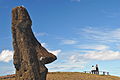
The moai in the park are of varying height from 2 to 20 metres (6 to 65 ft). The volcanic rock formations quarried for sculpting are a distinctive yellow-brown volcanic tuff found only at the Ranu Raraku on the southeast side of the island. Some of the moai were also carved from red scoria. [10] The ceremonial shrines where they are erected for offering worship are known as "ahu". Of impressive size and form, they are normally built close to the coast and parallel to it. Many unfinished moai are also found in the quarries. The production and transportation of the 887 statues are considered remarkable creative and physical feats. [7] [8] The moai have been under restoration since 1950. [11] The period between 1837 and 1864 was a critical time when, for reasons that remain unknown, all the standing statues were toppled (probably during the tribal wars), although with little damage. Subsequently they were retrieved and returned to their original positions during the period of restoration with international assistance. [12] The moai represented a clan's "most revered forebears who were believed to bestow ‘mana’ on living leaders". [12] The park also has a few petroglyphs and paintings. [12]

Rano Kau crater Rano-Kau-Crater-Gap-2013.jpg
Rano Kau crater

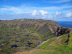
The Birdman cult which replaced the moai cult worship was concentrated in Orongo at a ceremonial site called Mata Ngarau. [7] The location is at an elevation of 250 metres (820 ft), on a narrow ridge between the ocean, and the deep crater of Rano Kau volcano, which last erupted about 150,000 to 210,000 years ago.

The earliest inhabitants of the island called it "Te Pito o TeHenua" (the navel/end of the world). The first European to discover the island was Dutch explorer Jacob Roggeveen on Easter day, 1722. As a result, he named it "Easter Island". He observed that the inhabitants were of three groups: "dark skinned, red skinned, and very pale skinned people with red hair". [13] In the 19th century, a Tahitian visitor who thought the island resembled Rapa but was bigger (nui means big), gave it the Polynesian name "Rapa Nui". In Chile, the island is called "Isla De Pascua" Spanish for Easter Island.

Ecology

As the island was isolated there are many endemic species of animals and plants. The park is under IUCN Management Category II in southeastern Polynesia. [5] Its biogeographic and ecological history has undergone a sea change from what existed in the ancient days when there were palm trees and a broad leaf forest. Before the Polynesians settled here in the 4th century, the island had an extensive forest cover of trees, shrubs, ferns, and grasses. The island is now almost completely grass-covered with only a few ornamental trees and shrubs scattered over the island. [3]

Flora

Of the 150 recorded plant species, 45 are endemic. However, the island is largely covered by grass with three endemic species. In ancient times the only species of tree found here were Sophora toromiro and Paschalococos . The toromiro tree is now extinct on the island and Paschalococos is a species that could be related to the Chilean palm, Jubaea chilensis . In the steppe areas of the island, the vegetation consists mostly of species of Austrostipa and Nassella . Other species recorded are of introduced varieties. Among the shrubs, the hau hau ( Triumfetta semitriloba ) is still present but Coprosma spp. , is not seen on the island. [3] [5] The wood of the now extinct Jubaea palm was used to make devices for transporting the huge stone moai statues. It has been established by carbon dating that this species of tree existed on the island till the 17th century. [3] Ferns are indigenous to Rapa Nui, and four of the 15 species noted are endemic: Doodia paschalis , Polystichum fuentesii , Elaphoglossum skottsbergii , and Thelypteris espinosae . Triumfetta semitriloba which was considered an extinct species on the island was located in 1988. According to a recent report (1991), apart from 166 introduced species of plants, 46 indigenous plant species including nine endemic species have been recorded. [3] Also noted in the lower level of the Rano Raraku crater are tall bulrushes like totora that were probably introduced by seafarers from South America. [3]

Fauna

The island's only mammals are rodents and carnivorans. The reptiles recorded are three species of marine turtles and two terrestrial lizards, Lepidodactylus lugubris and Ablepharus boutoui poecilopleurus . Four bird species – three terrestrial and one marine – are found on the island. These are: Fregata nubor , red-tailed tropicbird (Phaethon rubricauda), and Kermadec petrel. [5] Three micro-lepidopteran species are reported in the park which have no links to South American species; one of these is Asymphorodes trichogramma. [3]

Conservation

Invasive plants have been introduced for livestock grazing. Forest fires are a common feature, threatening the remaining native plant species. Archaeological investigations indicate the terrain is subject to damage from erosion and the influx of tourists. [3]

Though declared a national park in 1935, the first management plan (by CONAF) was not implemented until the 1980s. As a result of inadequate funding, conservation was initially at a low level leading international conservation agencies to provide financial and technical support. Chile responded by setting up a Rapa Nui Monuments Board which enabled actions to be taken independent of the government. The World Monument Fund started working here in 1968 with UNESCO later recognizing the site as a World Heritage site of cultural importance. With an airline operating (the airport built in 1965 was expanded in 1985 [4] ) between Chile and the island, more scientists have become interested in island's heritage, undertaking research on various aspects of its now defunct culture. [14]

The Rapa Nui National Park is now under the administrative control of the Ma´u Henua Polynesian Indigenous Community, which is the first autonomous institute on the island. The indigenous Rapa Nui people have regained authority over their ancestral lands and are in charge of the management, preservation and protection of their patrimony. On the first of December 2017, the ex-President Michelle Bachelet returned ancestral lands in the form of the Rapa Nui National Park to the indigenous people. For the first time in history, the revenue generated by the National Park is invested in the island and used to conserve the natural heritage.

Its conservation value is dictated by the archaeological investigations of the important intangible value of its cultural heritage. The management plan drawn by the park administration is oriented towards these archaeological investigations. Zoning of the park has been done accordingly under the classification of intangible zone, primitive zone, extensive use zone, service and CONAF (1976) zone and special use zone. [5] A harmonious blend of conservation activities in the reserve areas (including monoliths and structures) with agricultural activities, livestock grazing, orchards and traditional fishing sites has evolved in the integrated management plans for the island. [15]

Sister parks

Related Research Articles

<span class="mw-page-title-main">Easter Island</span> Chilean island in the Pacific

Easter Island is an island and special territory of Chile in the southeastern Pacific Ocean, at the southeasternmost point of the Polynesian Triangle in Oceania. The island is most famous for its nearly 1,000 extant monumental statues, called moai, which were created by the early Rapa Nui people. In 1995, UNESCO named Easter Island a World Heritage Site, with much of the island protected within Rapa Nui National Park.

<span class="mw-page-title-main">Hanga Roa</span> Main town of Easter Island, Chile

Hanga Roa is the main town, harbour and seat of Easter Island, a municipality of Chile. It is located in the southern part of the island's west coast, in the lowlands between the extinct volcanoes of Terevaka and Rano Kau.

<span class="mw-page-title-main">Moai</span> Monolithic human figures on Easter Island

Moai or moʻai are monolithic human figures carved by the Rapa Nui people on Rapa Nui in eastern Polynesia between the years 1250 and 1500. Nearly half are still at Rano Raraku, the main moai quarry, but hundreds were transported from there and set on stone platforms called ahu around the island's perimeter. Almost all moai have overly large heads, which comprise three-eighths the size of the whole statue. They have no legs. The moai are chiefly the living faces of deified ancestors. The statues still gazed inland across their clan lands when Europeans first visited the island in 1722, but all of them had fallen by the latter part of the 19th century. The moai were toppled in the late 18th and early 19th centuries, possibly as a result of European contact or internecine tribal wars.

<span class="mw-page-title-main">Rapa Nui people</span> Polynesian inhabitants of Easter Island

The Rapa Nui are the indigenous Polynesian peoples of Easter Island. The easternmost Polynesian culture, the descendants of the original people of Easter Island make up about 60% of the current Easter Island population and have a significant portion of their population residing in mainland Chile. They speak both the traditional Rapa Nui language and the primary language of Chile, Spanish. At the 2017 census there were 7,750 island inhabitants—almost all living in the village of Hanga Roa on the sheltered west coast.

<span class="mw-page-title-main">Rano Raraku</span> Volcanic crater in Easter Island

Rano Raraku is a volcanic crater formed of consolidated volcanic ash, or tuff, and located on the lower slopes of Terevaka in the Rapa Nui National Park on Easter Island in Chile. It was a quarry for about 500 years until the early eighteenth century, and supplied the stone from which about 95% of the island's known monolithic sculptures (moai) were carved. Rano Raraku is a visual record of moai design vocabulary and technological innovation, where 887 moai remain. Rano Raraku is in the World Heritage Site of Rapa Nui National Park and gives its name to one of the seven sections of the park.

<span class="mw-page-title-main">Katherine Routledge</span> British archaeologist

Katherine Maria Routledge was an English archaeologist and anthropologist who, in 1914, initiated and carried out much of the first true survey of Easter Island.

<i>Aku-Aku</i> Book by Thor Heyerdahl

Aku-Aku: the Secret of Easter Island is a 1957 book by Thor Heyerdahl published in Norwegian, Swedish, Danish and Finnish, and in French and English the following year. The book describes the 1955–1956 Norwegian Archaeological Expedition's investigations of Polynesian history and culture at Easter Island, the Austral Islands of Rapa Iti and Raivavae, and the Marquesas Islands of Nuku Hiva and Hiva Oa. Visits to Pitcairn Island, Mangareva and Tahiti are described as well.

<span class="mw-page-title-main">King of Easter Island</span> Polynesian kingdom ended in 1888

Easter Island was traditionally ruled by a monarchy, with a king as its leader.

<span class="mw-page-title-main">Orongo</span> Stone village and ceremonial center on Easter Island

Orongo is a stone village and ceremonial center at the southwestern tip of Rapa Nui. It consists of a collection of low, sod-covered, windowless, round-walled buildings with even lower doors positioned on the high south-westerly tip of the large volcanic caldera called Rano Kau. Below Orongo on one side a 300-meter barren cliff face drops down to the ocean; on the other, a more gentle but still very steep grassy slope leads down to a freshwater marsh inside the high caldera.

<span class="mw-page-title-main">Anakena</span>

Anakena is a white coral sand beach in Rapa Nui National Park on Rapa Nui, a Chilean island in the Pacific Ocean. Anakena has two ahus; Ahu-Ature has a single moai and Ahu Nao-Nao has seven, two of which have deteriorated. It also has a palm grove and a car park.

<span class="mw-page-title-main">Ahu Tongariki</span> Stone platform on Easter Island

Ahu Tongariki is the largest ahu on Easter Island. Its moais were toppled during the island's civil wars, and in the twentieth century the ahu was swept inland by a tsunami. It has since been restored and has fifteen moai, including one that weighs eighty-six tonnes, the heaviest ever erected on the island. Ahu Tongariki is one kilometer from Rano Raraku and Poike in the Hotu-iti area of Rapa Nui National Park. All the moai here face sunset during the winter solstice.

<span class="mw-page-title-main">Rano Kau</span> Dormant volcano in Easter Island

Rano Kau is a 324 m (1,063 ft) tall dormant volcano that forms the southwestern headland of Easter Island, a Chilean island in the Pacific Ocean. It was formed of basaltic lava flows in the Pleistocene with its youngest rocks dated at between 150,000 and 210,000 years ago.

<span class="mw-page-title-main">Terevaka</span> Extinct volcano in Easter Island

Ma'unga Terevaka is the largest, tallest and youngest of three main extinct volcanoes that form Easter Island. Several smaller volcanic cones and craters dot its slopes, including a crater hosting one of the island's three lakes, Rano Aroi.

<span class="mw-page-title-main">Ahu Akivi</span>

Ahu Akivi is a particular sacred place on the Chilean island of Rapa Nui, looking out towards the Pacific Ocean. The site has seven moai, all of equal shape and size, and is also known as a celestial observatory that was set up around the 16th century. The site is located inland, rather than along the coast. Moai statues were considered by the early people of Rapa Nui as their ancestors or Tupuna that were believed to be the reincarnation of important kings or leaders of their clans. The Moais were erected to protect and bring prosperity to their clan and village.

<span class="mw-page-title-main">Puna Pau</span> Prehistoric quarry in Easter Island

Maunga Puna Pau is a small crater or cinder cone and prehistoric quarry on the outskirts of Hanga Roa in the south west of Easter Island. Puna Pau gives its name to one of the seven regions of the Rapa Nui National Park.

<span class="mw-page-title-main">History of Easter Island</span>

Geologically one of the youngest inhabited territories on Earth, Easter Island, located in the mid-Pacific Ocean, was, for most of its history, one of the most isolated. Its inhabitants, the Rapa Nui, have endured famines, epidemics of disease, civil war, environmental collapse, slave raids, various colonial contacts, and have seen their population crash on more than one occasion. The ensuing cultural legacy has brought the island notoriety out of proportion to the number of its inhabitants.

<span class="mw-page-title-main">Tourism in Chile</span> Economy sector of Chile

Since the mid-1990s, tourism in Chile has become one of the main sources of income for the country, especially in its most extreme areas. In 2005, this sector grew by 13.6%, generating more than US$500 million, equivalent to 1.33% of the national GDP.

<span class="mw-page-title-main">Geography of Easter Island</span> Overview of the Geography of Easter Island

Easter Island is one of the world's most isolated inhabited islands. Its closest inhabited neighbours are the Chilean Juan Fernandez Islands, 1,850 km (1,150 mi) to the east, with approximately 850 inhabitants. The nearest continental point lies in central Chile near Concepción, at 3,512 kilometres (2,182 mi). Easter Island's latitude is similar to that of Caldera, Chile, and it lies 3,510 km (2,180 mi) west of continental Chile at its nearest point. Isla Salas y Gómez, 415 km (258 mi) to the east, is closer but is uninhabited. The Tristan da Cunha archipelago in the southern Atlantic competes for the title of the most remote island, lying 2,430 km (1,510 mi) from Saint Helena island and 2,816 km (1,750 mi) from the South African coast.

<span class="mw-page-title-main">Hotu-iti</span>

Hotu-iti is an area of southeastern Easter Island that takes its name from a local clan. Located in Rapa Nui National Park, the area includes Rano Raraku crater, the Ahu Tongariki site, and a small bay. In the 15th and 16th centuries, the Hotu-iti clan was one of two polities on Easter Island.

Gonzalo Figueroa Garcia Huidobro, often referred to simply as Gonzalo Figueroa, was an archaeologist and authority on the conservation of the archaeological heritage of Rapa Nui. Figueroa's work included participating in Thor Heyerdahl's Rapa Nui expedition, restoring Ahu Akivimoai with William Mulloy, and working generally for over four decades to conserve and, in some cases, restore the archaeological monuments of Rapa Nui for future generations.

References

  1. National Forest Corporation: Estadística Visitantes 2012, 11 January 2013
  2. "Bachelet firma traspaso de administración del Parque Nacional Rapa Nui".
  3. 1 2 3 4 5 6 7 8 9 10 11 "Rapa Nui subtropical broadleaf forests". World Wildlife Fund. Retrieved 4 August 2013.
  4. 1 2 "Easter Island Crib Sheet". Easter Island Primer. Retrieved 4 August 2013.
  5. 1 2 3 4 5 6 Session 1981, pp. 118–119.
  6. Haughton 2009, p. 88.
  7. 1 2 3 "Rapa Nui National Park – UNESCO World Heritage Centre". UNESCO Organization. Retrieved 3 August 2013.
  8. 1 2 "World Heritage List Rapa Nui NO 715" (PDF). UNESCO Organization. Retrieved 4 August 2013.
  9. "Easter Island fire causes 'irreparable' damage to famous moai statues". The Guardian. 7 October 2022. Retrieved 7 October 2022.
  10. SEAGER THOMAS, Mike (2014). "Stone use and avoidance on Easter Island: red scoria from the topknot quarry at Puna Pau and other sources". Archaeology in Oceania. 49 (2): 104–106.
  11. "UNESCO World Heritage Site #2: Rapa Nui National Park". Everything Everywhere.com. 12 December 2008. Retrieved 3 August 2013.
  12. 1 2 3 "Easter Island – The Statues and Rock Art of Rapa Nui". Bradshaw Foundation. Retrieved 4 August 2013.
  13. "Easter Island: stones, history. Easter Island". Lost Civilizations.net. 2 July 2007. Retrieved 13 August 2013.
  14. Stubbs & Makaš 2011, p. 665.
  15. "Planning National Parks for Ecodevelopment – Methods and Cases from Latin America". Peace Corps: Information collection and exchange. Retrieved 4 August 2013.
  16. Cooperación internacional entre parques nacionales Archived 2013-10-04 at the Wayback Machine

Bibliography

27°09′S109°27′W / 27.15°S 109.45°W / -27.15; -109.45