[[Santa Barbara County,California]]"},"coords":{"wt":"{{coord|34.5866555|-119.9809753|format=dms|region:US-CA_type:waterbody|display=inline,title}}"},"type":{"wt":"[[reservoir (water)|Reservoir]]"},"inflow":{"wt":"[[California Aqueduct]]
[[Santa Ynez River]]"},"outflow":{"wt":"[[Santa Ynez River]]"},"basin_countries":{"wt":"United States"},"length":{"wt":""},"width":{"wt":""},"area":{"wt":"{{convert|3100|acre|abbr=on}}"},"depth":{"wt":"{{convert|71|ft|m|abbr=on}}"},"max-depth":{"wt":"{{convert|150|ft|m|abbr=on}}"},"volume":{"wt":"{{nowrap|{{convert|205000|acre.ft|m3|abbr=on}}}}"},"shore":{"wt":"{{convert|22.44|mi|km|abbr=on}}"},"elevation":{"wt":"{{convert|753|ft|abbr=on}}\n"},"pushpin_map":{"wt":"California#USA"},"pushpin_label_position":{"wt":""},"pushpin_map_alt":{"wt":"Location of Lake Cachuma in California,USA."},"pushpin_map_caption":{"wt":""},"website":{"wt":""},"reference":{"wt":""}},"i":0}}]}" id="mwBw">.mw-parser-output .infobox-subbox{padding:0;border:none;margin:-3px;width:auto;min-width:100%;font-size:100%;clear:none;float:none;background-color:transparent}.mw-parser-output .infobox-3cols-child{margin:auto}.mw-parser-output .infobox .navbar{font-size:100%}body.skin-minerva .mw-parser-output .infobox-header,body.skin-minerva .mw-parser-output .infobox-subheader,body.skin-minerva .mw-parser-output .infobox-above,body.skin-minerva .mw-parser-output .infobox-title,body.skin-minerva .mw-parser-output .infobox-image,body.skin-minerva .mw-parser-output .infobox-full-data,body.skin-minerva .mw-parser-output .infobox-below{text-align:center}@media screen{html.skin-theme-clientpref-night .mw-parser-output .infobox-full-data:not(.notheme)>div:not(.notheme)[style]{background:#1f1f23!important;color:#f8f9fa}}@media screen and (prefers-color-scheme:dark){html.skin-theme-clientpref-os .mw-parser-output .infobox-full-data:not(.notheme) div:not(.notheme){background:#1f1f23!important;color:#f8f9fa}}@media(min-width:640px){body.skin--responsive .mw-parser-output .infobox-table{display:table!important}body.skin--responsive .mw-parser-output .infobox-table>caption{display:table-caption!important}body.skin--responsive .mw-parser-output .infobox-table>tbody{display:table-row-group}body.skin--responsive .mw-parser-output .infobox-table tr{display:table-row!important}body.skin--responsive .mw-parser-output .infobox-table th,body.skin--responsive .mw-parser-output .infobox-table td{padding-left:inherit;padding-right:inherit}}
Cachuma Lake | |
---|---|
![]() | |
Location | Los Padres National Forest Santa Barbara County, California |
Coordinates | 34°35′12″N119°58′52″W / 34.5866555°N 119.9809753°W |
Type | Reservoir |
Primary inflows | California Aqueduct Santa Ynez River |
Primary outflows | Santa Ynez River |
Basin countries | United States |
Surface area | 3,100 acres (1,300 ha) |
Average depth | 71 ft (22 m) |
Max. depth | 150 ft (46 m) |
Water volume | 205,000 acre⋅ft (253,000,000 m3) |
Shore length1 | 22.44 mi (36.11 km) |
Surface elevation | 753 ft (230 m) |
1 Shore length is not a well-defined measure. |
Cachuma Lake is a reservoir in the Santa Ynez Valley of central Santa Barbara County, California on the Santa Ynez River adjoining the north side of California State Route 154. The artificial lake was created by the construction of Bradbury Dam, a 201 ft (61 m) earth-fill structure built by the U.S. Bureau of Reclamation in 1953. Its surface area covers 3,100 acres (1,300 ha), with a maximum design capacity of 205,000 acre⋅ft (253,000,000 m3), but it is currently limited to 188,000 acre⋅ft (232,000,000 m3) due to sediment accumulation. [1] The late-December 2022 and early-January 2023 storms dramatically raised the water level in the lake, from an average of 33% full to 100% full for the first time in 12 years.
Built by the U.S. Bureau of Reclamation in 1953, the name "Cachuma" comes from a Chumash village that the Spanish spelled "Aquitsumu", from the Barbareño Chumash word aqitsu'm, meaning "sign". [2]
The U.S. Bureau of Reclamation oversees the lake’s operations and maintenance. Five agencies that stretch from Santa Ynez to Carpinteria take water from Cachuma. [3] The Central Coast Water Authority (CCWA) extension of the California Aqueduct completed in 1997, is a 30–39-inch diameter pipeline (76–99 cm) that travels 42 miles (68 km) from Vandenberg Space Force Base through Vandenberg Village, Lompoc, Buellton, and Solvang and terminates at Cachuma. [4]
The water levels of the lake are highly variable, spilling in some years and receding to less than 10% of capacity in dry years. [5] Drought conditions can cause shortage in water supplies, as did the 2011-17 drought. [3]
In October 2016, the lake approached low levels not seen since the construction of Bradbury Dam. The lake level reached a minimum of 646.42 ft (197.03 m) on October 14, more than 106 ft (32 m) below the spillway elevation. At this time, the storage volume was only 14,057 acre-feet (17,339,000 m3), approximately 7.3% of capacity. [5]
In January and February 2017, a series of frequent rains raised the water level substantially. On one day, February 17, 2017, the lake rose by 25 feet (7.6 m) during the storm alone, followed by further increases from storm runoff. [6] By the end of February 2017, the Lake had become 44.5% full, with a total volume of 85,979 acre-feet (106,054,000 m3). [7] The Lake's water level declined again during the 2017-18 water year, with the Lake receding to less than one-third of its capacity. [8] By March 28, 2019, above-normal precipitation had restored Lake Cachuma to 78.0% of its capacity. [9] [10]
Despite an abnormally dry January and February 2020, a wet March and April brought the lake to 77% of capacity as of April 7, 2020. [11]
Several consecutive atmospheric river storms coming in from the Pacific in late-December, 2022 and early-January, 2023 dramatically raised the water level in the lake, from an average of 33% full in late December, to nearly 100% full by January 15, 2023 for the first time in 12 years. [3] Further storms in February resulted in flood warnings for portions of Lompoc close to the river due to the water being released from the dam. [12]
Santa Barbara County Parks offers cabin and yurt rentals, as well as RV, tent, and group camping. Gasoline and groceries are available at the general store. [13] There is a full boat and kayak rental facility with a bait and tackle shop where fishing licenses can be purchased. The lake is stocked with rainbow trout throughout the winter season, and fishing is open all year from shore or boat. There are five miles of hiking trails within the park, and Los Padres National Forest trails close by.
A large campsite on the south shore of Cachuma Lake is administered by the Santa Barbara County Park's division of the Community Services Department.
The University of California, Santa Barbara rowing team regularly practices and races at Cachuma Lake and erected a permanent boathouse there just prior to the 1982-1983 school year. The lake is also a popular destination for viewing bald eagles from seasonal tour boats.
Body contact activities such as swimming, wading, or water skiing in Cachuma Lake have been restricted since the park opened in the 1950s, reasoning that the lake was a reservoir people depend upon for drinking water. In May 2011, the no body contact regulation was revised to allow human-powered recreational watercraft such as kayaks and canoes on the lake as well as allow dogs on boats and eliminate "incidental body contact" with the water as a punishable offense. [14]
Solvang, California is approximately 10.5 mi (16.9 km) to the west of Lake Cachuma. The town of Santa Ynez, California is approximately 7.25 mi (11.67 km) to the west of Bradbury Dam.
Santa Barbara County Parks offers a variety of natural programs including wildlife lake cruises, nature walks, junior ranger programs, campfire programs on summer weekends, and a family-oriented live animal event in the fall. School and community group environmental education field trips are available all year.
Located in Santa Barbara, the Neal Taylor Nature Center, formerly the Cachuma Lake Nature Center, features exhibits and hands-on displays about the area's cultural and natural history, including local plants, animals, birds and geology. The nature center is open year-round and admission is free. The center offers youth and adult workshops and lectures as well as school and youth nature education programs in partnership with the Santa Barbara County Parks natural history programs.
Lake Powell is a reservoir on the Colorado River in Utah and Arizona, United States. It is a major vacation destination visited by approximately two million people every year. It holds 24,322,000 acre-feet (3.0001×10¹⁰ m3) of water when full, second in the United States to only Lake Mead - though Lake Mead has fallen below Lake Powell in size several times during the 21st century in terms of volume of water, depth and surface area.
The Governor Edmund G. Brown California Aqueduct is a system of canals, tunnels, and pipelines that conveys water collected from the Sierra Nevada Mountains and valleys of Northern and Central California to Southern California. Named after California Governor Edmund Gerald "Pat" Brown Sr., the over 400-mile (640 km) aqueduct is the principal feature of the California State Water Project.
Lake Nacimiento is an 18-mile (29 km) long lake on the Nacimiento River in northern San Luis Obispo County, California. The lake contains many arms including Snake Creek and Dip Creek, nearer the dam, and the central Las Tablas and Franklin Creeks. Due to the dragon-like shape created by the positions of these arms, it is sometimes referred to as Dragon Lake.
Lake Oroville is a reservoir formed by the Oroville Dam impounding the Feather River, located in Butte County, northern California. The lake is situated 5 miles (8 km) northeast of the city of Oroville, within the Lake Oroville State Recreation Area, in the western foothills of the Sierra Nevada. Known as the second-largest reservoir in California, Lake Oroville is treated as a keystone facility within the California State Water Project by storing water, providing flood control, recreation, freshwater releases to assist in controlling the salinity intrusion into the Sacramento-San Joaquin Delta and protecting fish and wildlife.
New Melones Dam is an earth and rock filled embankment dam on the Stanislaus River, about 5 miles (8.0 km) west of Jamestown, California, United States, on the border of Calaveras County and Tuolumne County. The water impounded by the 625-foot-tall (191 m) dam forms New Melones Lake, California's fourth-largest reservoir, in the foothills of the Sierra Nevada east of the San Joaquin Valley. The dam serves mainly for irrigation water supply, and also provides hydropower generation, flood control, and recreation benefits.
San Luis Dam, also known as B.F. Sisk Dam, is a major earth-filled dam in Merced County, California, which forms San Luis Reservoir, the largest off-stream reservoir in the United States. The dam and reservoir are located in the Diablo Range to the east of Pacheco Pass and about 10 miles (16 km) west of Los Banos. San Luis Dam, a jointly-owned state and federal facility, stores more than 2 million acre feet (2.5 km3) of water for the California State Water Project and the federal Central Valley Project. Although the dam is located in the valley of San Luis Creek, the majority of its water comes from man-made aqueducts which are supplied from other rivers in Northern California.
The Santa Ynez River is one of the largest rivers on the Central Coast of California. It is 92 miles (148 km) long, flowing from east to west through the Santa Ynez Valley, reaching the Pacific Ocean at Surf, near Vandenberg Space Force Base and the city of Lompoc.
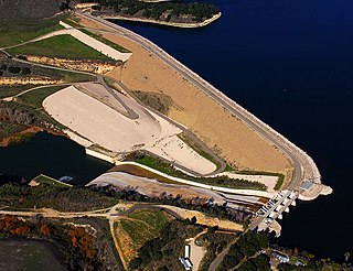
The San Luis Reservoir is an artificial lake on San Luis Creek in the eastern slopes of the Diablo Range of Merced County, California, approximately 12 mi (19 km) west of Los Banos on State Route 152, which crosses Pacheco Pass and runs along its north shore. It is the fifth largest reservoir in California. The reservoir stores water taken from the San Joaquin-Sacramento River Delta. Water is pumped uphill into the reservoir from the O'Neill Forebay which is fed by the California Aqueduct and is released back into the forebay to continue downstream along the aqueduct as needed for farm irrigation and other uses. Depending on water levels, the reservoir is approximately nine miles (14 km) long from north to south at its longest point, and five miles (8 km) wide. At the eastern end of the reservoir is the San Luis Dam, the fourth largest embankment dam in the United States, which allows for a total capacity of 2,041,000 acre-feet (2,518,000 dam3). Pacheco State Park lies along its western shores.
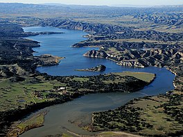
Lake Kaweah is a reservoir near Lemon Cove in Tulare County, California. The lake is formed by Terminus Dam on the Kaweah River. The river originates in the Sierra Nevada and drains about 560 sq mi (1,500 km2) into Lake Kaweah before flowing towards the San Joaquin Valley. From Lake Kaweah, the river flows toward the city of Visalia, splitting into the Kaweah River and St. Johns River as it flows west into the Tulare Lakebed. The lake has a capacity of 185,000 acre⋅ft (228,000,000 m3). A project to raise the lake 21 ft (6.4 m) was completed in 2004. The lake now impounds an additional 42,000 acre⋅ft (52,000,000 m3) and downstream flood protection to downstream communities and agricultural land has been increased.
The California State Water Project, commonly known as the SWP, is a state water management project in the U.S. state of California under the supervision of the California Department of Water Resources. The SWP is one of the largest public water and power utilities in the world, providing drinking water for more than 27 million people and generating an average of 6,500 GWh of hydroelectricity annually. However, as it is the largest single consumer of power in the state itself, it has a net usage of 5,100 GWh.
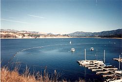
Lake Casitas is a reservoir in Ventura County, California, built by the United States Bureau of Reclamation and completed in 1959. The project provides drinking water and water for irrigation. A secondary benefit is flood control. It was the venue for canoeing and rowing at the 1984 Summer Olympics.
Twitchell Reservoir is a reservoir in southern San Luis Obispo County and northern Santa Barbara County in California. The reservoir has a capacity of 197,756 acre⋅ft (243,928,000 m3) and is formed by Twitchell Dam on the Cuyama River about 66 miles (106 km) from its headwaters in the Chumash Wilderness Area. About 7 miles (11 km) below the dam, outflow joins the Sisquoc River near Garey, CA to form the Santa Maria River.
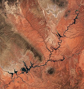
Lake McClure is a reservoir in the Sierra Nevada foothills of western Mariposa County, California, United States.
Folsom Lake is a reservoir on the American River in the Sierra Nevada foothills of California, United States. Folsom Lake with its surrounding Folsom Lake State Recreation Area is one of the most visited parks in the California park system.
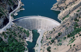
Monticello Dam is a 304-foot (93 m) high concrete arch dam in Napa County, California, United States, constructed between 1953 and 1957. The dam impounded Putah Creek to create Lake Berryessa in the Vaca Mountains.
Folsom Dam is a concrete gravity dam on the American River of Northern California in the United States, about 25 mi (40 km) northeast of Sacramento. The dam is 340 ft (100 m) high and 1,400 ft (430 m) long, flanked by earthen wing dams. It was completed in 1955, and officially opened the following year.
Sulphur Creek Dam is a dam across Sulphur Creek in Orange County, California. The dam creates Laguna Niguel Lake and is entirely within the city of Laguna Niguel. The reservoir is used for water reclamation storage and recreation, and is the main attraction of Laguna Niguel Regional Park, which surrounds it.
Bradbury Dam is an earthen dam across the Santa Ynez River in central Santa Barbara County, California. The dam forms Lake Cachuma, which provides the majority of water supplies within the county.
Gibraltar Dam is located on the Santa Ynez River, in southeastern Santa Barbara County, California, in the United States. Forming Gibraltar Reservoir, the dam is owned by the city of Santa Barbara. Originally constructed in 1920 and expanded in 1948, the dam and reservoir are located in a remote part of the Los Padres National Forest.
Salsipuedes Creek is a 9.9 miles (15.9 km) long stream, flowing north to join the Santa Ynez River just southeast of Lompoc in Santa Barbara County, California. Salsipuedes Creek, along with its major tributary, El Jaro Creek, is the largest tributary to the lower Santa Ynez River, shortly before the river reaches the Pacific Ocean.