Dinnington is a town and civil parish in the Metropolitan Borough of Rotherham in South Yorkshire, England. It is near to the towns of Worksop and Rotherham and cities of Sheffield and Doncaster.

Pitstone is a village and civil parish in east Buckinghamshire, England. It is at the foot of the central range of the Chiltern Hills, centred 6 miles (10 km) east of Aylesbury and 5 miles (8 km) south of Leighton Buzzard. It directly adjoins the village of Ivinghoe, and the two villages share some facilities.

Hatfield is a town and civil parish in the City of Doncaster in South Yorkshire, England. It had a population of 17,236 at the 2011 Census. The town is located on the A18 road between Doncaster and Scunthorpe, and to the west of the M18 motorway. It shares a railway station with Stainforth on the line between Goole and Scunthorpe, and Doncaster. Recorded history in the parish extends as far back as 730, when Bede wrote about the Northumbrian King, Edwin, being killed in battle in the area.
Tytherington is a village in the civil parish of Tytherington and Itchington, in the South Gloucestershire district, in the ceremonial county of Gloucestershire, England, situated 2 miles (3.2 km) south east of Thornbury. The parish population taken at the 2011 census was 666. On 1 April 2023 the parish was renamed from "Tytherington" to "Tytherington and Itchington".

Ashwell is a village and civil parish in the county of Rutland in the East Midlands of England. The population of the civil parish was 290 at the 2001 census falling to 269 at the 2011 census. It is located about 3 miles (5 km) north of Oakham.

Buxted is a village and civil parish in the Wealden district of East Sussex in England. The parish is situated on the Weald, north of Uckfield; the settlements of Five Ash Down, Heron's Ghyll and High Hurstwood are included within its boundaries. At one time its importance lay in the Wealden iron industry, and later it became commercially important in the poultry and egg industry.
Sprotbrough and Cusworth is a civil parish in the City of Doncaster in South Yorkshire, England, with most of its settlements on the western edge of the Doncaster built-up area. It lies between 1 mile (1.6 km) and 4 miles (6.4 km) to the west of Doncaster and is split by the A1(M) motorway. It had a population of 12,166 in 2001 and 12,134 at the 2011 Census. The parish covers some of Doncaster's outlying western suburbs and commuter belt including the villages of Sprotbrough, Cusworth, and a small part of Scawsby, in addition to several rural hamlets and farmsteads.

Bishop Monkton is a village and civil parish in the Harrogate district of North Yorkshire, England, about five miles south of Ripon. According to the 2001 census it had a population of 775, increasing slightly to 778 at the 2011 Census. In 2015, North Yorkshire County Council estimated the population to be 760.

Little Horsted is a village and civil parish in the Wealden district of East Sussex, England. It is located two miles (3.2 km) south of Uckfield, on the A26 road.

Edlington is a town and civil parish in the City of Doncaster, South Yorkshire, England, lying to the south west of Doncaster and Warmsworth. It has a population of 8,276. The original parish town of Edlington is now known as Old Edlington; adjacent, and to the north, is New Edlington. It is often referred to by locals as 'Edlo'. Since 1974 Edlington has been part of the Metropolitan Borough of Doncaster in the metropolitan county of South Yorkshire. It had, since 1894, formed part of Doncaster Rural District in the West Riding of Yorkshire.
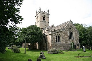
St James' Church, High Melton is a parish church of the Church of England in High Melton, South Yorkshire, England.

Melton is a village in the civil parish of Welton, East Riding of Yorkshire, England. It is situated about 8 miles (13 km) west of Kingston upon Hull city centre near to the Humber Estuary and about 0.6 miles (1 km) east of the village of Welton, with which it is nearly contiguous.

Bentley is a suburb of Doncaster in South Yorkshire, England two miles north of the city centre. The population of the ward within the City of Doncaster at the 2011 Census was 14,191. The Bentley built-up area subdivision had a population of 27,145.

Peckforton is a scattered settlement and civil parish in the unitary authority of Cheshire East and the ceremonial county of Cheshire, England. The settlement is located 6.5 miles (10.5 km) to the north east of Malpas and 7.5 miles (12.1 km) to the west of Nantwich. The civil parish covers 1,754 acres (710 ha), with an estimated total population of 150 in 2006. The area is predominantly agricultural. Nearby villages include Bulkeley to the south, Beeston to the north, Higher Burwardsley to the west, Spurstow to the east and Bunbury to the north east.
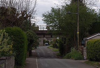
Hooton Levitt is a village and civil parish in the Metropolitan Borough of Rotherham in South Yorkshire, England; one of four villages in the county that carry the name of Hooton, meaning 'farmstead on a spur of land'. It has a population of 110, increasing to 132 at the 2011 Census.

King Sterndale is a village and civil parish in Derbyshire, England. It is located in the Peak District, 4 miles east of Buxton. It has a population of about 30, increasing to 133 at the 2011 Census. The two hamlets of Cowdale and Staden also lie within the parish.

Owston is a small village and civil parish in the City of Doncaster in rural South Yorkshire, England. Historically part of the West Riding of Yorkshire, the village is situated amongst mixed farmland and woodland 6 miles (9.7 km) north northwest of Doncaster, just west of the A19. It had a population of 170 in 2001, which fell to 145 according to the 2011 Census.

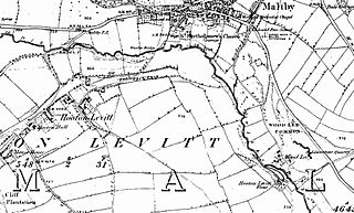
Levitt Hagg is an abandoned hamlet in South Yorkshire, located approximately two miles southwest of Doncaster and near Conisbrough Castle. Limestone began to be quarried at the site in ancient times. Levitt Hagg was also the site, along with nearby environs in the Don Gorge, of ancient woodlands rich in yew trees. The old settlement of Levitt Hagg was removed in the 1950s.

Wyham cum Cadeby is a depopulated civil parish in the East Lindsey district of Lincolnshire, England. The nearest village is Ludborough, about 1 mile (1.6 km) to the east on the A16 road, and the nearest town, Louth, 5 miles (8 km) to the south.

Warmsworth is a village and civil parish of Doncaster in the City of Doncaster in South Yorkshire, England. Its population was estimated at 3,908 in 2019. The village lies along the A1(M) Doncaster Bypass and the A630. The River Don is close to the village. Sprotbrough, Edlington, Conisbrough, Levitt Hagg and Balby surround Warmsworth. It lies 4 miles from Doncaster.


