Indonesia is an archipelagic country located in Southeast Asia and Oceania, lying between the Indian Ocean and the Pacific Ocean. It is located in a strategic location astride or along major sea lanes connecting East Asia, South Asia and Oceania. Indonesia is the largest archipelago in the world. Indonesia's various regional cultures have been shaped—although not specifically determined—by centuries of complex interactions with its physical environment.

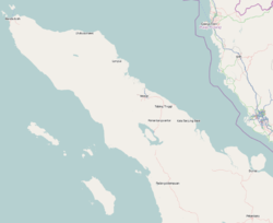
Sumatra is one of the Sunda Islands of western Indonesia. It is the largest island that is fully within Indonesian territory, as well as the sixth-largest island in the world at 482,286.55 km2 (182,812 mi.2), including adjacent islands such as the Simeulue, Nias, Mentawai, Enggano, Riau Islands, Bangka Belitung and Krakatoa archipelago.

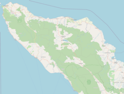
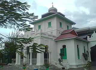
Aceh, officially the Province of Aceh, is the westernmost province of Indonesia. It is located on the northern end of Sumatra island, with Banda Aceh being its capital and largest city. It is bordered by the Indian Ocean to the west, Strait of Malacca to the northeast, as well bordering the province of North Sumatra to the east, its sole land border, and shares maritime borders with Malaysia and Thailand to the east, and Andaman and Nicobar Islands of India to the north. Granted a special autonomous status, Aceh is a religiously conservative territory and the only Indonesian province practicing Sharia law officially. There are ten indigenous ethnic groups in this region, the largest being the Acehnese people, accounting for approximately 70% of the region's population of about 5.5 million people in mid-2023. Its area is comparable to Croatia or Togo.

Banda Aceh is the capital and largest city in the province of Aceh, Indonesia. It is located on the island of Sumatra and has an elevation of 35 meters. The city covers an area of 61.36 square kilometers (23.69 sq mi) and had a population of 223,446 people at the 2010 Census, rising to 252,899 at the 2020 Census. The official estimate as at mid 2023 was 261,969.

On 26 December 2004, at 07:58:53 local time (UTC+7), a major earthquake with a magnitude of 9.2–9.3 struck with an epicentre off the west coast of northern Sumatra, Indonesia. The undersea megathrust earthquake, known by the scientific community as the Sumatra–Andaman earthquake, was caused by a rupture along the fault between the Burma plate and the Indian plate, and reached a Mercalli intensity up to IX in some areas.

Meulaboh is the capital of West Aceh Regency, Indonesia.

Leupung -- also spelled "Leupueng", is a district in Aceh Besar regency, close to the city of Banda Aceh, the capital of the special territory of Aceh, Indonesia, on the island of Sumatra. Leupung is located at 5'31" North latitude and 95'15" East longitude at an elevation of 33 m. The population in 2004 was approximately 10,000; the district has been obliterated by the tsunami resulting from the 2004 Indian Ocean earthquake, being one of the towns closest to the earthquake's epicenter.
Teunom, a town in the Aceh Jaya Regency of Aceh province on the island of Sumatra in Indonesia, with a population of about 12,000, was reported to have "vanished completely leaving only scattered shards of concrete" as a result of the tsunami produced by the 2004 Indian Ocean earthquake. Officials stated that 8,000 out of a population of 18,000 were killed.

Indonesia was the first country to be seriously affected by the earthquake and tsunami created by the 2004 Indian Ocean earthquake on 26 December 2004, swamping the northern and western coastal areas of Sumatra, and the smaller outlying islands off Sumatra. Nearly all the casualties and damage took place within the province of Aceh. The time of arrival of the tsunami was between 15 and 30 minutes after the deadly earthquake. According to the country's National Disaster Relief Coordination Agency, around 130,000 people were dead and 37,063 were missing. In addition, the UN estimated that 655,000 people were homeless and sheltering in scattered refugee camps across the province.

Aceh Jaya Regency is a regency of Aceh Province of Indonesia. It is located on the west side of the island of Sumatra, and was formed on 10 April 2002 from districts which had formerly been the northern part of West Aceh Regency. The regency covers an area of 3,872.23 square kilometres and had a population of 76,782 people at the 2010 census, 86,368 at the 2015 census and 93,159 at the 2020 Census, of whom 47,264 were male and 45,895 female; the official estimate as at mid 2023 was 99,717. The seat of the Regency is at Calang, in Krueng Sabee District. The main crops grown in the Regency are rice, rambutan, durian, orange, water melon, rubber, palm and coconut oil.
Gleebruk was a village in the district (Kabupaten/Kota) of Aceh Besar just to the southwest of Banda Aceh, the capital of the special territory of Aceh on the island of Sumatra, Indonesia. It was completely destroyed by the tsunamis resulting from the 2004 Indian Ocean earthquake.
The Indian Ocean Tsunami Warning System was set up to provide warning to inhabitants of nations bordering the Indian Ocean of approaching tsunamis. The tsunami warning system has been in use since the mid-2000s.

Weh Island is a small active volcanic island to the northwest of Sumatra in Indonesia, also known as Sabang after the city situated on the northeast end of the island, whose area of 122.13 square kilometres (47.15 sq mi) includes the whole island as well as several offshore islets. It had a population of 43,527 at the official mid-2023 estimate. It is 45 minutes by fast regular ship or 2 hours by ferry from the mainland port of Banda Aceh. It was originally connected to the Sumatran mainland and became separated by sea after the stratovolcano's last eruption in the Pleistocene era. The island is situated in the Andaman Sea.

Subulussalam is a city in the south of Aceh province of Indonesia. It is located inland on the island of Sumatra. On 2 January 2007, the provincial government of Aceh declared Subulussalam to be an independent city as a result of the administration being separated from that of Aceh Singkil Regency. of which it was formerly a part. It is located at 2°38′32″N98°00′15″E. It covers an area of 1,391 km2, and it had a population of 67,446 at the 2010 Census and of 90,751 at the 2020 Census; the official estimate as in mid 2023 was 97,770. As a result, Subulussalam is the most sparsely-populated city in Indonesia, with a population density of only 70.3 people per km2.

The Aceh River on the island of Sumatra in Indonesia flows from mountains that include the 2,780-metre high Mount Peuët Sagoë for some 200 kilometres northeastward to reach the junction of the Indian Ocean and the Andaman Sea at Banda Aceh, the capital of Indonesia's westernmost Aceh province. The river has a catchment area of some 1775 square kilometres.
Woyla River is a river in West Aceh Regency in northwestern Sumatra, Indonesia, about 1700 km northwest of the capital Jakarta.
Ulèë Lheuë is an area in Meuraxa sub-district, Banda Aceh, Indonesia. It was the former main seaport of Aceh. The town and seaport was heavily damaged and depopulated during the 2004 Indian Ocean earthquake and tsunami.

PLTD Apung 1 is a tourist attraction and former electric generator barge, stranded on dry land in Banda Aceh, Sumatra, Indonesia. The 2,600-ton vessel was at sea when the 2004 Indian Ocean earthquake and tsunami occurred, with the tsunami carrying it two to three kilometres inland. The Apung 1, then owned by the local power generating company, crashed into two homes when it was taken ashore, killing those inside.
The 2012 Indian Ocean earthquakes were magnitude 8.6 and 8.2 Mw undersea earthquakes that struck near the Indonesian province of Aceh on 11 April at 15:38 local time. Initially, authorities feared that the initial earthquake would cause a tsunami and warnings were issued across the Indian Ocean; however, these warnings were subsequently cancelled. These were unusually strong intraplate earthquakes and the largest strike-slip earthquake ever recorded.
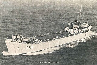
USS Solano County (LST-1128) was a LST-542-class tank landing ship in the United States Navy during World War II. She was transferred to the Indonesian Navy as KRI Teluk Langsa.