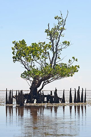
A mangrove is a shrub or tree that grows mainly in coastal saline or brackish water. Mangroves grow in an equatorial climate, typically along coastlines and tidal rivers. They have special adaptations to take in extra oxygen and to remove salt, which allow them to tolerate conditions that would kill most plants. The term is also used for tropical coastal vegetation consisting of such species. Mangroves are taxonomically diverse, as a result of convergent evolution in several plant families. They occur worldwide in the tropics and subtropics and even some temperate coastal areas, mainly between latitudes 30° N and 30° S, with the greatest mangrove area within 5° of the equator. Mangrove plant families first appeared during the Late Cretaceous to Paleocene epochs, and became widely distributed in part due to the movement of tectonic plates. The oldest known fossils of mangrove palm date to 75 million years ago.

An estuary is a partially enclosed coastal body of brackish water with one or more rivers or streams flowing into it, and with a free connection to the open sea. Estuaries form a transition zone between river environments and maritime environments and are an example of an ecotone. Estuaries are subject both to marine influences such as tides, waves, and the influx of saline water, and to fluvial influences such as flows of freshwater and sediment. The mixing of seawater and freshwater provides high levels of nutrients both in the water column and in sediment, making estuaries among the most productive natural habitats in the world.

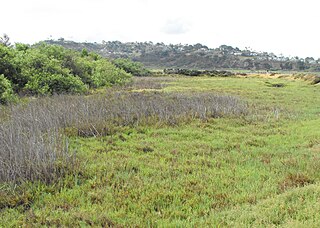
A marsh is — according to ecological definitions — a wetland that is dominated by herbaceous rather than woody plant species. More in general, the word can be used for any low-lying and seasonally waterlogged terrain. In Europe and in agricultural literature low-lying meadows that require draining and embanked polderlands are also referred to as marshes or marshland.

Long Island Sound is a marine sound and tidal estuary of the Atlantic Ocean. It lies predominantly between the U.S. state of Connecticut to the north and Long Island in New York to the south. From west to east, the sound stretches 110 mi (180 km) from the East River in New York City, along the North Shore of Long Island, to Block Island Sound. A mix of freshwater from tributaries, and saltwater from the Atlantic Ocean, Long Island Sound is 21 mi (34 km) at its widest point and varies in depth from 65 to 230 feet.

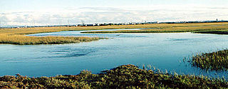
A salt marsh, saltmarsh or salting, also known as a coastal salt marsh or a tidal marsh, is a coastal ecosystem in the upper coastal intertidal zone between land and open saltwater or brackish water that is regularly flooded by the tides. It is dominated by dense stands of salt-tolerant plants such as herbs, grasses, or low shrubs. These plants are terrestrial in origin and are essential to the stability of the salt marsh in trapping and binding sediments. Salt marshes play a large role in the aquatic food web and the delivery of nutrients to coastal waters. They also support terrestrial animals and provide coastal protection.

Fitzgerald Marine Reserve is a marine reserve in California on the Pacific Ocean, located just north of Pillar Point Harbor and Mavericks in the San Mateo County community of Moss Beach. Moss Beach is located approximately 20 miles (32 km) south of San Francisco and 50 miles (80 km) north of Santa Cruz. The reserve is a 32-acre (0.13 km2) holding which extends from Montara light station at the north to Pillar Point on the south. The reserve consists of a three-mile stretch of beach, tidepool habitat, marsh, erosive bluffs, clifftop trail and cypress and eucalyptus forests. The property is owned by the State of California and managed by San Mateo County as a county park and nature preserve. The reserve is administratively assigned to be part of the Monterey Bay National Marine Sanctuary. Adjacent to and possibly within the reserve is an endangered species of butterfly, the San Bruno elfin butterfly.

A tidal marsh is a marsh found along rivers, coasts and estuaries which floods and drains by the tidal movement of the adjacent estuary, sea or ocean. Tidal marshes experience many overlapping persistent cycles, including diurnal and semi-diurnal tides, day-night temperature fluctuations, spring-neap tides, seasonal vegetation growth and decay, upland runoff, decadal climate variations, and centennial to millennial trends in sea level and climate.

Mangrove forests, also called mangrove swamps, mangrove thickets or mangals, are productive wetlands that occur in coastal intertidal zones. Mangrove forests grow mainly at tropical and subtropical latitudes because mangroves cannot withstand freezing temperatures. There are about 80 different species of mangroves, all of which grow in areas with low-oxygen soil, where slow-moving waters allow fine sediments to accumulate.

Seal Slough, also known as Marina Lagoon, is a narrow winding tidal channel through a tidal marsh in San Mateo and Foster City, California. This slough has been the object of a wetland restoration project in recent years to enhance habitat value. Dredging has been carried out in Seal Slough since at least 1954. When the original sewage treatment plant for the city of San Mateo was constructed in 1935, its discharge was directed to Seal Slough.
The Seal Beach National Wildlife Refuge is a wildlife refuge encompassing 965 acres (3.91 km2) located in the California coastal community of Seal Beach. Although it is located in Orange County it is included as part of the San Diego National Wildlife Refuge Complex. It was established in 1972.

Elkhorn Slough is a 7-mile-long (11 km) tidal slough and estuary on Monterey Bay in Monterey County, California. It is California's second largest estuary and the United States' first estuarine sanctuary. The community of Moss Landing and the Moss Landing Power Plant are located at the mouth of the slough on the bay.

Judith Shulman Weis is an American marine biologist. Her research and writing focuses on estuarine ecology and ecotoxicology, including the responses of salt marsh and brackish marsh organisms, populations and communities to stresses, particularly heavy metal contaminants, invasive species and parasites. She is also working to reduce the spread of microplastics in the environment and find solutions to protecting coastal marshes from sea level rise.
Brackish marshes develop from salt marshes where a significant freshwater influx dilutes the seawater to brackish levels of salinity. This commonly happens upstream from salt marshes by estuaries of coastal rivers or near the mouths of coastal rivers with heavy freshwater discharges in the conditions of low tidal ranges.

High marsh is a tidal marsh zone located above the Mean Highwater Mark (MHW) which, in contrast to the low marsh zone, is inundated infrequently during periods of extreme high tide and storm surge associated with coastal storms. This zone is impacted by spring tides, which is a bi-monthly lunar occurrence where the high marsh experiences higher inundation levels. The high marsh is the intermittent zone between the low marsh and the uplands, an entirely terrestrial area rarely flooded during events of extreme tidal action caused by severe coastal storms. The high marsh is distinguished from the low marsh by its sandy soil and higher elevation. The elevation of the high marsh allows this zone to be covered by the high tide for no more than an hour a day. With the soil exposed to air for long periods of time, evaporation occurs, leading to high salinity levels, up to four times that of sea water. Areas of extremely high salinity prohibit plant growth altogether. These barren sandy areas are known as "salt pans". Some cordgrass plants do survive here, but are stunted and do not reach their full size.
Low marsh is a tidal marsh zone located below the Mean Highwater Mark (MHM). Based on elevation, frequency of submersion, soil characteristics, vegetation, microbial community, and other metrics, salt marshes can be divided to into three distinct areas: low marsh, middle marsh/high marsh, and the upland zone. Low marsh is characterized as being flooded daily with each high tide, while remaining exposed during low tides.

Geukensia demissa is a species of mussel, a marine bivalve mollusk in the family Mytilidae, the true mussels. This species is native to the Atlantic coast of North America. The common names for this species include ribbed mussel, Atlantic ribbed marsh mussel and ribbed horsemussel. However, the common name ribbed mussel is also used for the Southern Hemisphere mussel Aulacomya atra. The appearance of the shell is grooved and oval in shape. The interior of this mussel is tinted purple
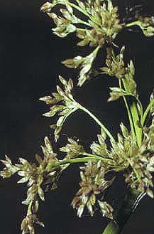
Juncus roemerianus is a species of flowering plant in the rush family known by the common names black rush, needlerush, and black needlerush. It is native to North America, where its main distribution lies along the coastline of the southeastern United States, including the Gulf Coast. It occurs from New Jersey to Texas, with outlying populations in Connecticut, New York, Mexico, and certain Caribbean islands.

Salt marsh die-off is a term that has been used in the US and UK to describe the death of salt marsh cordgrass leading to subsequent degradation of habitat, specifically in the low marsh zones of salt marshes on the coasts of the Western Atlantic. Cordgrass normally anchors sediment in salt marshes; its loss leads to decreased substrate hardness, increased erosion, and collapse of creek banks into the water, ultimately resulting in decreased marsh health and productivity.
The Kendall-Frost Mission Bay Marsh Reserve is a 20-acre University of California Natural Reserve System reserve on the northern shore of Mission Bay in San Diego County, California. Administered by UC San Diego, the site is owned by the University of California and managed for teaching and research.
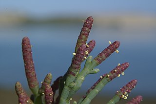
Salicornia pacifica, also known as pickleweed, sea asparagus, Pacific swampfire, or glasswort, is a species of low-growing perennial succulent halophyte in the genus Salicornia found in the Pacific coast of North America and California.

