Emu Plains is a suburb of Sydney in the state of New South Wales, Australia. It is 58 kilometres west of the Sydney central business district, in the local government area of the City of Penrith and is part of the Greater Western Sydney region.

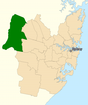
The Division of Lindsay is an Australian electoral division in the state of New South Wales.
Kingswood is a suburb in western Sydney, in the state of New South Wales in Australia. It is 52 kilometres west of the Sydney central business district, in the local government area of the City of Penrith. There are various other locations within the state of New South Wales that are also called Kingswood, and is often confused with the nearby suburb of Kingswood Park.
Werrington Downs is a suburb of Western Sydney. It is 52 kilometres (32 mi) west of the Sydney central business district, in the local government area of the City of Penrith and is part of the Greater Western Sydney region.

Werrington is a suburb of Sydney, in the state of New South Wales, Australia. It is 49.3 kilometres (30.6 mi) west of the Sydney central business district, in the local government area of the City of Penrith and is part of the Greater Western Sydney region.

St Marys is a suburb in western Sydney, in the state of New South Wales, Australia. It is 45 kilometres west of the Sydney central business district, in the local government area of the City of Penrith.

St Clair is a suburb of Sydney, in the state of New South Wales, Australia. It is 44 kilometres west of the Sydney central business district, in the local government area of the City of Penrith and is part of the Greater Western Sydney region. St Clair is within view of the Blue Mountains.

South Penrith is a suburb of Sydney, in the state of New South Wales, Australia. South Penrith is located 55 kilometres west of the Sydney central business district, in the local government area of the City of Penrith and is part of the Greater Western Sydney region.
Regentville is a suburb of Sydney, in the state of New South Wales, Australia. It is 56 kilometres west of the Sydney central business district, in the local government area of the City of Penrith, and is part of the Greater Western Sydney region. It is located on the eastern bank of the Nepean River, just south of Jamisontown.
Jamisontown is a suburb of Sydney, in the state of New South Wales, Australia. It is 56 kilometres west of the Sydney central business district, in the local government area of the City of Penrith, and is part of the Greater Western Sydney region. It is on the eastern side of the Nepean River, just south of Penrith and bears the name of Thomas Jamison, a pioneer landowner and First Fleet surgeon.
Kemps Creek is a suburb of Sydney, in the state of New South Wales, Australia. It is approximately 39 kilometres (24 mi) west of the Sydney central business district, in the local government areas of the City of Penrith and City of Liverpool. It is part of the Greater Western Sydney region.
Leonay is a suburb of Sydney, in the state of New South Wales, Australia 58 kilometres west of the Sydney central business district, in the local government area of the City of Penrith. It is part of the Greater Western Sydney region.
Llandilo is a suburb of Sydney, in the state of New South Wales, Australia 54 kilometres north-west of the Sydney central business district, in the local government area of the City of Penrith. It is part of the Greater Western Sydney region. Llandilo is a small semi-rural outcrop between two creeks.
Werrington County is a suburb of Sydney, in the state of New South Wales, Australia. It is 50 kilometres (31 mi) west of the Sydney central business district, in the local government area of the City of Penrith and is part of the Greater Western Sydney region. The suburb is entirely residential with a high proportion of individual separate dwellings.
Bringelly is a suburb of Sydney, in the state of New South Wales, Australia. It is located on the Northern Road between Penrith and Camden. It has a public school. Bringelly is also the name of a local hill.
Cambridge Park is a suburb of Sydney, in the state of New South Wales, Australia 53 kilometres west of the Sydney central business district, in the local government area of the City of Penrith. It is part of the Greater Western Sydney region.
Claremont Meadows is a suburb of Sydney, in the state of New South Wales, Australia. Claremont Meadows is located 45 kilometres west of the Sydney central business district, in the local government area of the City of Penrith and is part of the Greater Western Sydney region.

Glenmore Park is a suburb of Sydney, in the state of New South Wales, Australia. Glenmore Park is located 54 kilometres (34 mi) west of the Sydney central business district, in the local government area of the City of Penrith and is part of the Greater Western Sydney region.

North St Marys is a suburb in western Sydney, in the state of New South Wales Australia. North St Marys is located 47 kilometres west of the Sydney central business district, in the local government area of the City of Penrith. North St Marys is an extension of the adjoining suburb of St Marys.
Caddens is a suburb of Sydney, in the state of New South Wales in Australia. It is a new masterplanned residential neighborhood located 48 kilometres west of the Sydney central business district, in the local government area of the City of Penrith featuring views of the scenic Blue Mountains. The suburb's postcode is 2747.


