Piacenza d'Adige is a comune (municipality) in the Province of Padua in the Italian region Veneto, located about 70 kilometres (43 mi) southwest of Venice and about 40 kilometres (25 mi) southwest of Padua. As of 31 December 2004, it had a population of 1,371 and an area of 18.6 square kilometres (7.2 sq mi).

Ponso is a comune (municipality) in the Province of Padua in the Italian region Veneto, located about 60 kilometres (37 mi) southwest of Venice and about 35 kilometres (22 mi) southwest of Padua. As of 31 December 2004, it had a population of 2,435 and an area of 10.9 square kilometres (4.2 sq mi).
Besenzone is a comune (municipality) in the Province of Piacenza in the Italian region Emilia-Romagna, located about 120 kilometres (75 mi) northwest of Bologna and about 20 kilometres (12 mi) southeast of Piacenza.

Caorso is a comune (municipality) in the Province of Piacenza in the Italian region Emilia-Romagna, located about 130 kilometres (81 mi) northwest of Bologna and about 13 kilometres (8 mi) east of Piacenza.
Cerignale is a comune (municipality) in the Province of Piacenza in the Italian region Emilia-Romagna, located about 160 kilometres (99 mi) west of Bologna and about 50 kilometres (31 mi) southwest of Piacenza. As of 31 December 2004, it had a population of 197 and an area of 31.5 square kilometres (12.2 sq mi).

Corte Brugnatella is a comune (municipality) in the Province of Piacenza in the Italian region Emilia-Romagna, located about 160 kilometres (99 mi) west of Bologna and about 45 kilometres (28 mi) southwest of Piacenza.
Farini is a comune (municipality) in the Province of Piacenza in the Italian region Emilia-Romagna, located about 140 kilometres (87 mi) west of Bologna and about 40 kilometres (25 mi) southwest of Piacenza. As of 31 December 2004, it had a population of 1,744 and an area of 112.0 square kilometres (43.2 sq mi).
Gazzola is a comune (municipality) in the Province of Piacenza in the Italian region Emilia-Romagna, located about 150 kilometres (93 mi) northwest of Bologna and about 15 kilometres (9 mi) southwest of Piacenza. As of 31 December 2004, it had a population of 1,856 and an area of 44.1 square kilometres (17.0 sq mi).
Gossolengo is a comune (municipality) in the province of Piacenza in the Italian region Emilia-Romagna, located about 150 kilometres (93 mi) northwest of Bologna and about 9 kilometres (6 mi) southwest of Piacenza, in the valley of the Trebbia river.
Morfasso is a comune (municipality) in the Province of Piacenza in the Italian region Emilia-Romagna, located about 130 kilometres (81 mi) west of Bologna and about 35 kilometres (22 mi) south of Piacenza. As of 31 December 2011, it had a population of 1,090 and an area of 83.6 square kilometres (32.3 sq mi).
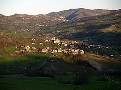
Ottone is a comune (municipality) in the Province of Piacenza in the Italian region Emilia-Romagna, located about 160 kilometres (99 mi) west of Bologna and about 60 kilometres (37 mi) southwest of Piacenza, in the upper Val Trebbia on the Ligurian Apennine. Ottone is the westernmost comune of Emilia-Romagna. The Mount Alfeo is located in its territory.
Pecorara is a town and former comune (municipality) in the Province of Piacenza in the Italian region Emilia-Romagna, located about 160 kilometres (99 mi) northwest of Bologna and about 30 kilometres (19 mi) southwest of Piacenza. Since 2018, it has been a frazione of the comune of Alta Val Tidone.

Pontenure is a comune (municipality) in the Province of Piacenza in the Italian region Emilia-Romagna, located about 140 kilometres (87 mi) northwest of Bologna and about 9 kilometres (6 mi) southeast of Piacenza.
Rivergaro is a comune (municipality) in the Province of Piacenza in the Italian region Emilia-Romagna, located about 150 kilometres (93 mi) northwest of Bologna and about 20 kilometres (12 mi) southwest of Piacenza. As of 31 December 2011, it had a population of 6,843 and an area of 43.8 square kilometres (16.9 sq mi).
Rottofreno is a comune (municipality) in the Province of Piacenza in the Italian region Emilia-Romagna, located about 160 kilometres (99 mi) northwest of Bologna and about 12 kilometres (7 mi) west of Piacenza.

Sarmato is a comune (municipality) in the Province of Piacenza in the Italian region Emilia-Romagna, located about 160 kilometres (99 mi) northwest of Bologna and about 15 kilometres (9 mi) west of Piacenza. As of 31 December 2004, it had a population of 2,714 and an area of 27.0 square kilometres (10.4 sq mi). Sarmato borders the following municipalities: Borgonovo Val Tidone, Castel San Giovanni, Monticelli Pavese, Pieve Porto Morone, Rottofreno.

Ziano Piacentino is a comune (municipality) in the Province of Piacenza in the Italian region Emilia-Romagna, located about 160 kilometres (99 mi) northwest of Bologna and about 25 kilometres (16 mi) west of Piacenza. Ziano Piacentino borders the following municipalities: Alta Val Tidone, Borgonovo Val Tidone, Castel San Giovanni, Rovescala, Santa Maria della Versa.

San Rocco al Porto is a comune (municipality) in the Province of Lodi in the Italian region Lombardy, located about 50 kilometres (31 mi) southeast of Milan and about 25 kilometres (16 mi) southeast of Lodi. As of 31 December 2004, it had a population of 3,383 and an area of 30.7 square kilometres (11.9 sq mi).

Alta Val Tidone is a new comune (municipality) in the Province of Piacenza in the Italian region Emilia-Romagna, located about 180 kilometres (110 mi) northwest of Bologna and about 30 kilometres (19 mi) southwest of Piacenza.