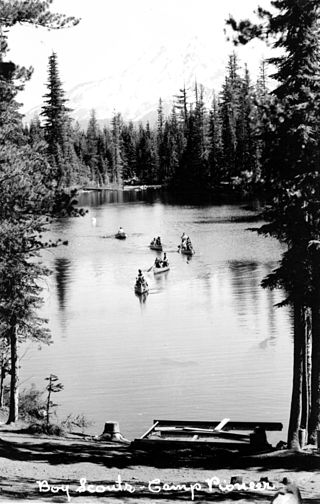
Scouting in the U.S. state of Oregon includes the Boy Scouts of America (BSA) and Girl Scouts (GSUSA) youth organizations, as well as newer organizations like the Baden-Powell Service Association.
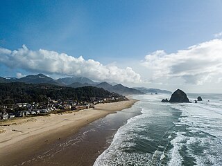
Cannon Beach is a city in Clatsop County, Oregon, United States. Its population was 1,690 at the 2010 census. It is a popular coastal Oregon tourist destination, famous for Haystack Rock, a 235 ft (72 m) sea stack that juts out along the coast. In 2013, National Geographic listed it as "one of the world's 100 most beautiful places."

Yachats is a small coastal city in the southernmost area of Lincoln County, Oregon, United States. According to Oregon Geographic Names, the name comes from the Siletz language and means "dark water at the foot of the mountain". There is a range of differing etymologies. William Bright says the name comes from the Alsea placename yáx̣ayky. At the 2020 census, the city's population was 994.
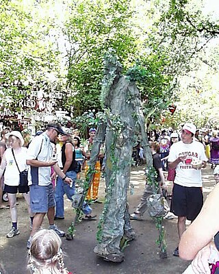
The Oregon Country Fair (OCF) is a nonprofit organization and an annual three-day art and music fair held outside the city limits of Veneta, Oregon, United States. Located in the Willamette Valley, the site is about 13 miles (21 km) west of Eugene along the Long Tom River near the unincorporated community of Elmira. Annual attendance is approximately 35,000, and the fair has around 960 craft and food booths each year. The event is known as an outgrowth of the counter-culture movement and for using environmentally-friendly practices during the fair.

The Oregon Coast is a coastal region of the U.S. state of Oregon. It is bordered by the Pacific Ocean to its west and the Oregon Coast Range to the east, and stretches approximately 362 miles (583 km) from the California state border in the south to the Columbia River in the north. The region is not a specific geological, environmental, or political entity, and includes the Columbia River Estuary.
The Klamath River flows 257 miles (414 km) through Oregon and northern California in the United States, emptying into the Pacific Ocean. By average discharge, the Klamath is the second largest river in California after the Sacramento River. Its nearly 16,000-square-mile (41,000 km2) watershed stretches from the high desert of south-central Oregon to the temperate rainforest of the North Coast. Unlike most rivers, the Klamath begins in a desert region and flows through the rugged Cascade Range and Klamath Mountains before reaching the ocean; National Geographic magazine has called the Klamath "a river upside down".

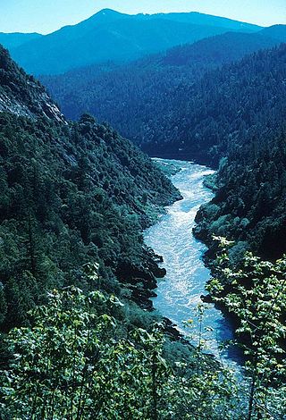
The Rogue River in southwestern Oregon in the United States flows about 215 miles (346 km) in a generally westward direction from the Cascade Range to the Pacific Ocean. Known for its salmon runs, whitewater rafting, and rugged scenery, it was one of the original eight rivers named in the Wild and Scenic Rivers Act of 1968. Beginning near Crater Lake, which occupies the caldera left by the explosive volcanic eruption and collapse of Mount Mazama, the river flows through the geologically young High Cascades and the older Western Cascades, another volcanic province. Further west, the river passes through multiple exotic terranes of the more ancient Klamath Mountains. In the Kalmiopsis Wilderness section of the Rogue basin are some of the world's best examples of rocks that form the Earth's mantle. Near the mouth of the river, the only dinosaur fragments ever discovered in Oregon were found in the Otter Point Formation, along the coast of Curry County.
Fort Hall was a fort in the Western United States that was built in 1834 as a fur trading post by Nathaniel Jarvis Wyeth. It was located on the Snake River in the eastern Oregon Country, now part of present-day Bannock County in southeastern Idaho. Wyeth was an inventor and businessman from Boston, Massachusetts, who also founded a post at Fort William, in present-day Portland, Oregon, as part of a plan for a new trading and fisheries company. In 1837, unable to compete with the powerful British Hudson's Bay Company, based at Fort Vancouver, Wyeth sold both posts to it. Great Britain and the United States both operated in the Oregon Country in these years.

The Oregon Dunes National Recreation Area is located on the Oregon Coast, stretching approximately 40 miles (64 km) north of the Coos River in North Bend to the Siuslaw River in Florence, and adjoining Honeyman State Park on the west. It is part of Siuslaw National Forest and is administered by the United States Forest Service.
The Golden Isles of Georgia consist of barrier islands, and the mainland port cities of Brunswick and Darien, on the 100-mile-long coast of the U.S. state of Georgia on the Atlantic Ocean. They include St. Simons Island, Sea Island, Jekyll Island, Little St. Simons Island, Sapelo Island, Blackbeard Island, Historic Darien and Historic Brunswick. The islands are part of a long chain of barrier islands known as the "Sea Islands", located along the coasts of South Carolina, Georgia and northern Florida.

Bronte Creek Provincial Park is located in Oakville, Ontario, Canada, and is part of the Ontario Parks system.

Oswald West State Park is part of the state park system of the U.S. state of Oregon. It is located about 10 miles (16 km) south of the city of Cannon Beach, adjacent to Arch Cape, on the Pacific Ocean. The park covers 2,448 acres (9.91 km2), with many miles of hiking trails both inside the park grounds and linking to other parks and landmarks beyond.

Hood To Coast is a long distance relay race that starts at Mount Hood and continues nearly 200 miles to the Oregon Coast. Known as "the mother of all relays", it is the largest running and walking relay in the world, with 12,600 runners in the Hood To Coast relay and 19,000 total participants, including events like the Portland To Coast Walk. Founded in 1982, Hood To Coast is extremely popular and has filled its team limit for the past 36 years, most of the time on opening day of the entrance lottery.
Scouting in British Columbia has a long history, from the 1900s to the present day, serving thousands of youth in programs that suit the environment in which they live.

Oxbow Regional Park is a 1,000-acre (4.0 km2) natural area park located ten miles (16 km) southeast of Troutdale along the Sandy River in the U.S. state of Oregon. Owned and operated by Metro regional government, it hosts a yearly festival celebrating salmon.

The Land Conservancy of San Luis Obispo County (LCSLO) is a non-profit land trust organization that has been operating in San Luis Obispo County, California since 1984. The LCSLO is dedicated to the voluntary and collaborative preservation and improvement of lands that hold significant scenic, agricultural, habitat, and cultural values. Their work aims to benefit both the local community and wildlife that depends on these lands.
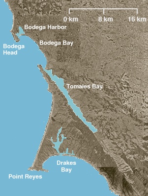
Point Reyes State Marine Reserve (SMR) and Point Reyes State Marine Conservation Area (SMCA) are two adjoining marine protected areas that extend offshore of Point Reyes Headlands and within Drakes Bay in Marin County on California’s north central coast. The combined area of these marine protected areas is 21.49 square miles, with 9.38 in the SMR, and 12.11 in the adjacent SMCA. Point Reyes SMR prohibits the take of all living marine resources. Point Reyes SMCA prohibits the take of all living marine resources, except the recreational and commercial take of Dungeness crab by pot and salmon by trolling.

Russian River State Marine Recreational Management Area (SMRMA) and Russian River State Marine Conservation Area (SMCA) are two adjoining marine protected areas in the Russian River estuary area in Sonoma County, California, on the north-central coast of the state. The combined area of these marine protected areas is 1.21 square miles (3.1 km2), with 0.35 square miles (0.91 km2) in the SMRMA and 0.86 square miles (2.2 km2) in the SMCA.
Randolph is an unincorporated community in Coos County, Oregon, United States. It is on the north bank the Coquille River about 7 miles (11 km) north of Bandon and about 3 miles east of the Pacific Ocean. Randolph was originally located about three miles to the northwest near the current Whiskey Run Beach, where it was a "black sand" gold mining boomtown in the 1850s. Today that boomtown is a ghost town because there are no significant structures left at the site, but the community on the Coquille River has several homes and a historic cemetery.
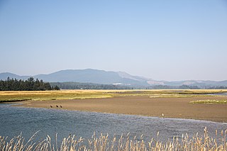
Sitka Sedge State Natural Area is an estuary and beach on the north coast of the U.S. state of Oregon in Tillamook County. Sitka Sedge consists of 357 acres (144 ha) of tidal marsh, mudflats, dunes, forested wetlands, and uplands at the south end of the Sand Lake estuary, north of Tierra Del Mar.
