Vermont Route 114 (VT 114) is a 53.094-mile-long (85.447 km) north–south state highway in northeastern Vermont in the United States. It runs northward from U.S. Route 5 (US 5) in Lyndon until nearing the Canada–United States border in the town of Norton; thereafter, the road continues east to the New Hampshire state line in Canaan. The vast majority of VT 114 is situated within Essex County; however, the route also passes through small, isolated portions of Caledonia and Orleans Counties.
Trout River is a border crossing connecting Elgin, Quebec to Constable, New York on the Canada–US border, most prominently featuring the Trout River Border Inspection Station. The crossing can be reached by New York State Route 30 on the American side and by Quebec Route 138 on the Canadian side.

Fort Covington–Dundee is a border crossing connecting Dundee, Quebec, in Canada to Fort Covington, New York, on the Canada–United States border. It can be reached by Quebec Route 132 on the Canadian side and by Dundee Road on the American side. The crossing is notable because the boundary line crosses through the now-defunct Taillon's International Hotel, where it was possible to order a drink in Canada and play pool in the United States. The hotel was built in 1820, prior to the Webster–Ashburton Treaty of 1842, which redefined this section of the international border.

The Chateaugay–Herdman Border Crossing connects the towns of Hinchinbrooke, Quebec to Chateaugay, New York on the Canada–US border. The crossing can be reached by New York State Route 374 on the American side, while Chemin Herdman connects it to Quebec Route 202 on the Canadian side. This crossing is open 24 Hours per day, 365 days per year. Border inspections at the crossing were established in 1933 in response to a surge in alcohol smuggling from Canada into the United States. The U.S. border station and inspector's residence built at that time are still in use, and were listed on the National Register of Historic Places in 2014.

The Mooers–Hemmingford Border Crossing connects the towns of Hemmingford, Quebec, to Mooers, New York, on the Canada–US border. It can be reached by Quebec Route 219 on the Canadian side and by Hemmingford Road on the American side. This crossing is open 24 hours per day, 365 days per year. The US government is still using the same border station it did when the crossing was first established in 1935. In 2014, the building was listed on the U.S. National Register of Historic Places.

The Overton Corners–Lacolle 221 Border Crossing connects the towns of Lacolle, Quebec to Champlain, New York on the Canada–United States border. This crossing is open 24 hours per day, 365 days per year. Because the village of Lacolle, Quebec has two border crossings, this one is called 221 to indicate it is the crossing on Quebec Route 221. The other crossing is the Rouses Point–Lacolle 223 Border Crossing immediately to the east. Conversely, the US Border station is sometimes called 276 because it is located on New York State Route 276.

The Rouses Point - Lacolle 223 Border Crossing connects the towns of Lacolle, Quebec and Rouses Point, New York on the Canada–US border. The crossing is open 24 hours per day, 365 days per year. Because the municipality of Lacolle, Quebec has two border crossings, CBSA calls this one 223 to indicate it is the crossing on Quebec Route 223. Historically, it was called Cantic, a local village name that is no longer used.

The Alburg Springs–Clarenceville Border Crossing connects the villages of Clarenceville, Quebec and Alburgh, Vermont on the Canada–United States border. The border crossing is open daily between 8:00 AM and 4:00 pm. Canada built a new border inspection station in 2005, while the US continues to use its Depression-era border station, listed on the National Register of Historic Places in 2014.
The West Berkshire–Frelighsburg Border Crossing connects the town of Frelighsburg, Quebec with the western portion of Berkshire, Vermont on the Canada–United States border. It is reached by Vermont Route 108 on the American side and by Quebec Route 237 on the Canadian side.

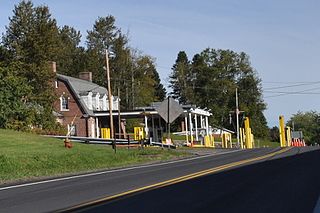
The Richford–Abercorn Border Crossing connects the town of Abercorn, Quebec with the town of Richford, Vermont on the Canada–US border. It is located at the meeting point of Quebec Route 139 and Vermont Route 139, roughly midway between the two village centers. A United States border station has existed here since at least 1926; the present 1935 station was listed on the US National Register of Historic Places in 2014. Both stations are open 24 hours per day, seven days per week.
The East Richford–Glen Sutton Border Crossing connects the towns of Sutton, Quebec and Richford, Vermont on the Canada–US border. During the early 20th century, this scenic road was a major east–west thoroughfare. In 1936, the United States built a large border station that is still in use today, and is listed on the National Register of Historic Places. By coincidence, the actual border crossing is on the Missisquoi River Bridge, built in 1929 and also listed on the US National Register. The original bridge, built in 1926, was destroyed only a year later in the Great Vermont Flood of 1927. The US and the Canadian stations are open daily from 8:00am to 4:00pm.

The North Troy–Highwater Border Crossing connects the town of Highwater, Quebec with North Troy, Vermont on the Canada–US border. It is located at the meeting point of Vermont Route 243 and Quebec Route 243. Both stations are open 24 hours per day for non-commercial traffic; the Canadian station is open to commercial traffic on weekdays during business hours. The former US station facilities, dating to the 1930s, are listed on the National Register of Historic Places.
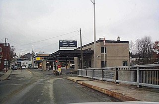
The Derby Line–Stanstead Border Crossing is a border crossing station on the Canada–United States border, connecting the towns of Stanstead, Quebec and Derby Line, Vermont. It connects Main Street in Derby Line with Quebec Route 143 in Stanstead. It is one of two local crossings between the two towns, which historically had many more. This was a major crossing point until the construction of Interstate 91 (I-91) and the Derby Line–Rock Island Border Crossing in 1965. The historic 1930s United States station facilities were listed on the National Register of Historic Places in 2014. Both stations are open 24 hours per day.

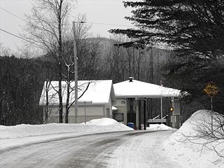
The Norton–Stanhope Border Crossing connects the towns of Stanhope, Quebec and Norton, Vermont on the Canada–US border. The crossing, at the meeting point of Quebec Route 147 and Vermont Route 147, is the only crossing between the two communities. The US border station, built in 1933, was listed on the National Register of Historic Places in 2014. Both stations are open 24 hours a day.
The Beecher Falls–East Hereford Border Crossing connects the towns of East Hereford, Quebec, and the village of Beecher Falls, Vermont, on the Canada–United States border. It is reached by Vermont Route 253 on the American side and by Quebec Route 253 on the Canadian side. Both the Canadian and the U.S. stations are open 24 hours a day. Whilst the Canadian station is open for commercial traffic, this is only on a more limited basis. The U.S. station facilities, built in the 1930s, was listed on the National Register of Historic Places in 2014.

The Coburn Gore–Woburn Border Crossing connects the towns of Woburn, Quebec, and Coburn Gore, Maine, along the Canada–United States border. It is a land crossing, located where Quebec Route 161 and Maine State Route 27 meet. The U.S. border station, built in 1931, is listed on the National Register of Historic Places.

The Limestone–Gillespie Portage Border Crossing is an international border crossing connecting the towns of Limestone, Maine, United States, and Grand-Sault, New Brunswick, Canada. The crossing is reached by Maine State Route 229 on the American side and by New Brunswick Route 375 on the Canadian side. The United States crossing facilities are the original facilities first built for this crossing in 1933, and were listed on the National Register of Historic Places in 2014.

The Fort Fairfield–Andover Border Crossing is an international border crossing between the towns of Fort Fairfield, Maine, United States, and Southern Victoria, Canada on the Canada–US border, joining Maine State Route 161 and New Brunswick Route 190. The United States border station was built in 1933, and was listed on the National Register of Historic Places in 2014. The Canada border station was built in 2007, replacing the previous facility that was built in 1954. This crossing was a historical flashpoint during the bloodless Aroostook War of the 1830s, in which the US and Great Britain disputed the border's location. That dispute was ended with the Webster-Ashburton Treaty in 1842.

The Orient–Fosterville Border Crossing is an international border crossing between the towns of Orient, Maine, United States and Fosterville, New Brunswick, Canada on the Canada–US border. At this crossing, the United States is still operating the original border station built in 1937, which was listed on the National Register of Historic Places in 2014. Canada built its current border station in 1986. This section of the border is a series of lakes and streams that supply the St Croix River. The original bridge connecting Orient with Fosterville was said to be the shortest international bridge between the US and Canada.

The Ferry Point Bridge Crossing connects the towns of Calais, Maine and St. Stephen, New Brunswick on the Canada–US border. This crossing is located at the Ferry Point International Bridge. Various bridges have existed at this location since 1826. In 1847, a more substantial covered toll bridge was completed. It was replaced by a steel bridge in 1895 that featured a streetcar line, and it no longer required payment of a toll. This bridge was for many years the principal crossing point between the two communities. In 2009, after the completion of the International Avenue Border Crossing, commercial trucks were prohibited from crossing the border at this location, significantly reducing the through truck traffic passing through the nearby downtown areas.
