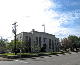
Polk County is a county located in the southeastern corner of the U.S. state of Tennessee. As of the 2020 United States census, its population was 17,544. Its county seat is Benton. The county was created on November 28, 1839, from parts of Bradley and McMinn counties, after final removal of most Cherokee from the region that year. The county was named after then-governor James K. Polk. Polk County is included in the Cleveland, Tennessee Metropolitan Area Statistical Area, which is also included in the Chattanooga–Cleveland–Dalton, TN–GA–AL Combined Statistical Area.
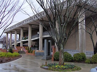
Bradley County is a county located in the southeastern portion of the U.S. state of Tennessee. As of the 2020 census, the population was 108,620, making it the thirteenth most populous county in Tennessee. Its county seat is Cleveland. It is named for Colonel Edward Bradley of Shelby County, Tennessee, who was colonel of Hale's Regiment in the American Revolution and the 15th Regiment of the Tennessee Volunteers in the War of 1812. Bradley County is included in the Cleveland, Tennessee Metropolitan Statistical Area, which is also included in the Chattanooga-Cleveland-Dalton, TN-GA-AL Combined Statistical Area.

Hayesville is a town in Clay County, North Carolina, United States. The population was 311 at the 2010 census. It is the county seat of Clay County.

Charleston is a city in Bradley County, Tennessee, United States. The population was 664 at the 2020 census. It is included in the Cleveland Metropolitan Statistical Area.

Cleveland is the county seat of and largest city in Bradley County, Tennessee, United States. The population was 47,356 at the 2020 census. It is the principal city of the Cleveland metropolitan area, Tennessee, which is included in the Chattanooga–Cleveland–Dalton, TN–GA–AL Combined Statistical Area.

The Hiwassee River has its headwaters on the north slope of Rocky Mountain in Towns County in the northern area of the State of Georgia. It flows northward into North Carolina before turning westward into Tennessee, flowing into the Tennessee River a few miles west of what is now State Route 58 in Meigs County, Tennessee. The river is about 147 miles (237 km) long.
Chatata, meaning "clear water", is the original Cherokee name of an area located in Bradley County, Tennessee. Today the name survives in references to a number of locations in Bradley County, most notably Chatata Valley in the northeastern part of the county. Chatata was also the original name of an unincorporated community in this region now known as Tasso.

Red Clay State Historic Park is a state park located in southern Bradley County, Tennessee, United States. The park was the site of the last capital of the Cherokee Nation in the eastern United States from 1832 to 1838 before the enforcement of the Indian Removal Act of 1830. This resulted in a forced migration of most of the Cherokee people to present-day Oklahoma known as the Cherokee removal. The site is considered sacred to the Cherokees, and includes the Blue Hole Spring, a large hydrological spring. It is also listed as an interpretive center along the Trail of Tears National Historic Trail.

Kituwa or giduwa (Cherokee:ᎩᏚᏩ) is an ancient Native American settlement near the upper Tuckasegee River, and is claimed by the Cherokee people as their original town. An earthwork platform mound, built about 1000 CE, marks a ceremonial site here. The historic Cherokee built a townhouse on top that was used for their communal gatherings and decisionmaking; they replaced it repeatedly over decades. They identify Kituwa as one of the "seven mother towns" in their traditional homeland of the American Southeast. This site is in modern Swain County, North Carolina, in the Great Smoky Mountains.
The Pisgah phase is an archaeological phase of the South Appalachian Mississippian culture in Southeast North America. It is associated with the Appalachian Summit area of southeastern Tennessee, Western North Carolina, and northwestern South Carolina in what is now the United States.

The Valley River is a tributary of the Hiwassee River. It arises as a pair of springs in the Snowbird Mountains of Cherokee County, North Carolina and descends 2,960 feet (900 m) in elevation in approximately forty miles (64 km) to enter the Hiwassee embayment at present-day Murphy, North Carolina.
The Dallas phase is an archaeological phase, within the Mississippian III period, in the South Appalachian Geologic province in North America.

APD-40 or APD 40 refers to a road composed of the U.S. Route 64 Bypass and a section of State Route 60 (SR 60) which forms a partial beltway around the business district of Cleveland, Tennessee. The route takes its name from its part of Corridor K of the Appalachian Development Highway System, and is sometimes called Appalachian Highway or simply the Cleveland Bypass. The route is also designated as Veterans Memorial Highway. The US 64 Byp. section of the road is also multiplexed with unsigned State Route 311 and US 74, and is also known as the US 74 Bypass. The road is a four-lane divided highway its entire length and parts are controlled-access. The bypass is an east-west route and the state route is a north-south.

The Spikebuck Town Mound and Village Site is a prehistoric and historic archaeological site on Town Creek near its confluence with the Hiwassee River within the boundaries of present-day Hayesville, North Carolina. The site encompasses the former area of the Cherokee village of Quanassee and associated farmsteads. The village was centered on what is known as Spikebuck Mound, an earthwork platform mound, likely built about 1,000 CE by ancestral indigenous peoples during the South Appalachian Mississippian culture period.

Too-Cowee, was an important historic Cherokee town located near the Little Tennessee River north of present-day Franklin, North Carolina. It also had a prehistoric platform mound and earlier village built by ancestral peoples. As their expression of public architecture, the Cherokee built a townhouse on top of the mound. It was the place for their community gatherings in their highly decentralized society. The name translates to "pig fat" in English. British traders and colonists referred to Cowee as one of the Cherokee Middle Towns along this river; they defined geographic groupings based in relation to their coastal settlements, such as Charlestown, South Carolina.
The C.S.M. Paul B. Huff Medal of Honor Memorial Parkway, more commonly known as Paul B. Huff Parkway or Paul Huff Parkway, is a major east–west thoroughfare which runs through northern Cleveland, Tennessee. While not a numbered highway, it serves as a connector between U.S. Route 11 (US 11) and State Route 60 (SR 60) as well as to Interstate 75 (I-75), is maintained by the Tennessee Department of Transportation (TDOT), and has come to be one of the most heavily traveled and widely used roads in the city, with many corporate and private businesses locating to it. In 2017 the parkway had an annual average daily traffic (AADT) volume of 26,762 vehicles. The road is named in honor of Paul B. Huff, a Cleveland-born recipient of the Medal of Honor for his actions in World War II.

State Route 30 is an east-west state highway in the central and eastern portions of the U.S. state of Tennessee. It runs generally west to east, connecting McMinnville in Warren County with Parksville along the Ocoee River in Polk County. It crosses several major geographic features in Tennessee, including the Cumberland Plateau, the Sequatchie Valley, the Tennessee River, and parts of the Cherokee National Forest.

State Route 308 is a secondary state route located in northern Bradley County, Tennessee that serves the city of Charleston. The route is 7.5 miles (12.1 km) long and is located entirely in Bradley County.
The Hiwassee River Heritage Center is a history museum located in Charleston, Tennessee which was established in 2013. The museum chronicles the region's Cherokee and Civil War history. It is a certified interpretive center on the Trail of Tears National Historic Trail.
Hiwassee Island, also known as Jollys Island and Benham Island, is located in Meigs County, Tennessee, at the confluence of the Tennessee and Hiwassee Rivers. It is about 35 mi (56 km) northeast of Chattanooga. The island was the second largest land mass on the Tennessee River at 781 acres before the Tennessee Valley Authority created the Chickamauga Lake as a part of the dam system on the Tennessee River in 1940. Much of the island is now submerged, leaving 400 acres above the waterline.
