Bradley County is a county located in the southeastern portion of the U.S. state of Tennessee. As of the 2020 census, the population was 108,620, making it the thirteenth most populous county in Tennessee. Its county seat is Cleveland. It is named for Colonel Edward Bradley of Shelby County, Tennessee, who was colonel of Hale's Regiment in the American Revolution and the 15th Regiment of the Tennessee Volunteers in the War of 1812. Bradley County is included in the Cleveland, Tennessee Metropolitan Statistical Area, which is also included in the Chattanooga-Cleveland-Dalton, TN-GA-AL Combined Statistical Area.

Strasburg is an unincorporated town located east of downtown Denver along the I-70 corridor. It is home to Strasburg School District 31-J, and there are several small businesses, medical clinics, and a post office. Strasburg is a census-designated place (CDP) located in and governed by Adams and Arapahoe counties, Colorado, United States. The CDP is a part of the Denver–Aurora–Lakewood, CO Metropolitan Statistical Area. The Strasburg post office has the ZIP Code 80136. At the United States Census 2020, the population of the Strasburg CDP was 3,307.

Sedalia is an unincorporated town, a post office, and a census-designated place (CDP) located in and governed by Douglas County, Colorado, United States. The CDP is a part of the Denver–Aurora–Lakewood, CO Metropolitan Statistical Area. The Sedalia post office has the ZIP Code 80135. At the United States Census 2020, the population of the Sedalia CDP was 177.

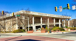
Cleveland is the county seat of, and largest city in, Bradley County, Tennessee. The population was 47,356 at the 2020 census. It is the principal city of the Cleveland metropolitan area, Tennessee, which is included in the Chattanooga–Cleveland–Dalton, TN–GA–AL Combined Statistical Area.

Channelview is a census-designated place (CDP) in the U.S. state of Texas on the east side of Houston in Harris County. Its population was 45,688 at the 2020 U.S. census.

Georgetown is an unincorporated community at the junction of Bradley, Hamilton, and Meigs counties, Tennessee. The community is located along State Route 60 near its intersection with State Route 58.
Oak Ridge is an unincorporated community and census-designated place (CDP) located along the border of West Milford Township in Passaic County and Jefferson Township in Morris County, in the U.S. state of New Jersey. The area is served as United States Postal Service ZIP Code 07438.

East Rochester is an unincorporated community and census-designated place in southern West Township, Columbiana County, Ohio, United States. The population was 224 as of the 2020 census. It lies along U.S. Route 30 about 20 miles (32 km) east of Canton, and has a post office with the ZIP code 44625.
Unionville is an unincorporated community and census-designated place (CDP) in Bedford County, Tennessee. Its population was 1,394 as of the 2020 census. Unionville has a post office with ZIP code 37180.
Conasauga is a CDP in southern Polk County, Tennessee, United States. It is located approximately 1.2 miles north of the Tennessee-Georgia state line and roughly 17 miles southeast of Cleveland. The Conasauga River Lumber Company is located at Conasauga.

Mooresburg is a census-designated place (CDP) and an unincorporated town in Hawkins County, Tennessee. Its population was 941 as of the 2010 census. It is located along U.S. Route 11W between Rogersville and Bean Station.

Christiana is an unincorporated community and census-designated place in Rutherford County, Tennessee, United States. It has a post office, with ZIP code 37037. Christiana Middle School is located in the community. Both U.S. Route 231 and Tennessee State Route 269 pass through the community.

Flintville is an unincorporated community in Lincoln County, Tennessee, United States. As of the 2010 census, its population was 627. Flintville is located approximately 10.5 miles (16.9 km) southeast of Fayetteville along Tennessee State Route 275 highway.

Pocahontas is an unincorporated community and census-designated place (CDP) in Hardeman and McNairy counties, Tennessee, United States. It is eighty-three miles southeast of Memphis.
Finley is an unincorporated community in Dyer County, Tennessee, United States. It is located roughly 5.5 miles west of downtown Dyersburg along Tennessee State Route 104. Tennessee State Route 182 also passes through the community, which connects it with Interstate 155 and Lenox to the north.
Lenox is an unincorporated community in Dyer County, Tennessee, United States. Its ZIP code is 38047.
Dellrose is an unincorporated community in Lincoln County, Tennessee, United States. It has a post office, with ZIP code 38453. It is located along Tennessee State Route 273 between Elkton and Fayetteville.

Grimsley is an unincorporated community and census-designated place (CDP) in Fentress County, Tennessee, United States. Its population was 1,167 as of the 2010 census. Its ZIP code is 38565.

Pelham is an unincorporated community and census-designated place (CDP) in Grundy County, Tennessee, United States. As of the 2010 census, its population was 403. Pelham is located at the junction of U.S. Route 41, State Route 2, and State Route 50 near the base of the Cumberland Plateau, 5.35 miles (8.61 km) north-northwest of Monteagle. Pelham has a post office with ZIP code 37366, which opened on April 4, 1832.

Sherwood is an unincorporated community in Franklin County, Tennessee, United States. It is located along Tennessee State Route 56 13.1 miles (21.1 km) southeast of Winchester, and just north of the Alabama state line. Sherwood has a post office with ZIP code 37376.