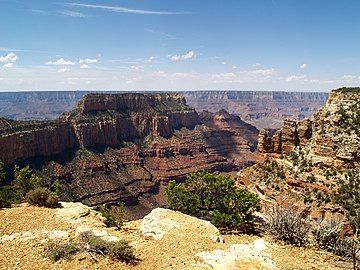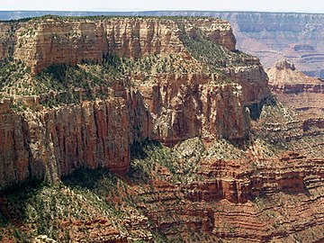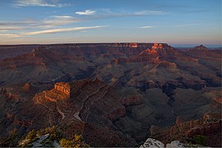
Newton Butte, in the Grand Canyon, Arizona, United States is a prominence below the South Rim, northwest of Grandview Point, and north on a ridgeline from Shoshone Point which is one mile east of Yaki Point, East Rim Drive. Shoshone Point and Yaki are both on access roads from East Rim Drive, with Yaki being the more advantageous to different viewing directions.

Temple Butte, in the Grand Canyon, Arizona, US is a prominence below the East Rim. The butte lies on the west bank of the south-flowing Colorado River. The outfall from the Little Colorado River, draining from the Painted Desert to the east and southeast, is about 2-mi upstream.

Isis Temple is a prominence in the Grand Canyon, Arizona, Southwestern United States. It is located below the North Rim and adjacent to Granite Gorge. The prominence lies north of the north bank of the west-flowing Colorado River and is just north of Granite Gorge. The Trinity Creek and canyon flow due south at its west border; its north, and northeast border/flank is formed by Phantom Creek and canyon, a west tributary of Bright Angel Creek; the creeks intersect about 3 mi (4.8 km) southeast, and 1.0 mi (1.6 km) north of Granite Gorge. The Isis Temple prominence, is only about 202 ft (62 m) lower than Grand Canyon Village, the main public center on Grand Canyon’s South Rim.
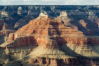
The Lower Permian Esplanade Sandstone is a cliff-forming, resistant sandstone, dark red, geologic unit found in the Grand Canyon. The rock unit forms a resistant shelf in the west Grand Canyon, south side of the Colorado River, at the east of the Toroweap Fault, down-dropped to west, southeast of Toroweap Overlook, and west of Havasupai. The red, sandstone shelf, The Esplanade is about 20-mi long. At Toroweap Overlook region, Toroweap Valley with Vulcan's Throne, Uinkaret volcanic field, the resistant Esplanade Sandstone is described in access routes exploring the Toroweap Lake area.

Zoroaster Temple is a 7,123-foot-elevation summit located in the Grand Canyon, in Coconino County of Arizona, USA. It is situated 5.5 miles northeast of the Yavapai Point overlook on the canyon's South Rim, from which it can be seen towering over 4,600 feet above the Colorado River and Granite Gorge. Its nearest higher neighbor is Brahma Temple, less than one mile to the north-northeast. Zoroaster Temple is named for Zoroaster, an ancient Iranian prophet. This name was used by George Wharton James and Clarence Dutton. Dutton began the tradition of naming geographical features in the Grand Canyon after mythological deities. This geographical feature's name was officially adopted in 1906 by the U.S. Board on Geographic Names.
The first ascent of the summit was made by Rick Tidrick and Dave Ganci in September 1958 via the NE Arete (class 5.9+). Other climbing routes include Screaming Sky Crack, and SE Face, a challenging class 5.11+ route that was first climbed in 2012. The 1958 Zoroaster ascent was the first technical climb in the Grand Canyon, transforming the Grand Canyon into a climbing mecca and setting off a rush to climb the many summits. According to the Köppen climate classification system, Zoroaster Temple is located in a Cold semi-arid climate zone.

Brahma Temple is a 7,551-foot-elevation summit located in the Grand Canyon, in Coconino County of Arizona, US. It is situated six miles (9.7 km) north-northeast of the Yavapai Point overlook on the canyon's South Rim, and 4.5 miles south of the North Rim's Bright Angel Point. It towers 5,000 feet above Phantom Ranch in Bright Angel Canyon. Its nearest higher neighbor is Oza Butte, four miles to the north-northwest. Other neighbors include Zoroaster Temple one mile to the south, and Deva Temple, 1.5 miles to the north. Brahma Temple is named for Brahma, the Hindu creator of the universe. This name was applied by Clarence Dutton who began the tradition of naming geographical features in the Grand Canyon after mythological deities. This geographical feature's name was officially adopted in 1906 by the U.S. Board on Geographic Names.
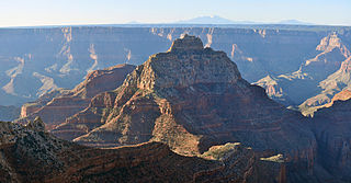
Vishnu Temple is a 7,533-foot-elevation (2,296 meter) summit located in the Grand Canyon, in Coconino County of Arizona, US. It is situated two miles south-southeast of the Cape Royal overlook on the canyon's North Rim, 1.5 mile south of Freya Castle, and two miles east-southeast of Wotans Throne, its nearest higher neighbor. It towers 4,900 feet (1,490 meters) above the Colorado River. According to explorer Frederick Samuel Dellenbaugh, Vishnu Temple is "without doubt the most stupendous mass of nature's carving in the known world."
Vishnu Temple is named for Vishnu, the Hindu deity, redeemer of the universe. This name was applied in 1880 by Clarence Dutton who thought this mountain resembled an oriental pagoda, and who began the tradition of naming geographical features in the Grand Canyon after mythological deities. This geographical feature's name was officially adopted in 1906 by the U.S. Board on Geographic Names. The first ascent of the summit was made by Merrel Clubb and his son on July 13, 1945. According to the Köppen climate classification system, Vishnu Temple is located in a cold semi-arid climate zone.

Wotans Throne is a 7,721-foot-elevation (2,353 meter) summit located in the Grand Canyon, in Coconino County of Arizona, US. It is situated one mile immediately southwest of the Cape Royal overlook on the canyon's North Rim, 1.7 mile west-southwest of Freya Castle, two miles west-northwest of Vishnu Temple, and five miles east of Zoroaster Temple. It rises 5,200 feet (1,585 meters) above the Colorado River.

Shiva Temple is a 7,646-foot-elevation (2,331 meter) summit located in the Grand Canyon, in Coconino County of Arizona, US. It is situated six miles north of Hopi Point overlook of the canyon's South Rim, about 2.5 miles southwest of North Rim’s Tiyo Point, and two miles northwest of Isis Temple, where it towers 5,200 feet (1,585 meters) above the Colorado River. Shiva Temple is named for Shiva, the Hindu deity, destroyer of the universe. This name was applied by Clarence Dutton who began the tradition of naming geographical features in the Grand Canyon after mythological deities. Dutton believed Shiva Temple was the largest, grandest, and most majestic of the Grand Canyon buttes, with a broad, level, forested top. This mountain's name was officially adopted in 1906 by the U.S. Board on Geographic Names.
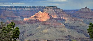
Angels Gate is a 6,761-foot (2,061 m)-elevation summit located in the Grand Canyon, in Coconino County of Arizona, United States. It is situated seven miles (11 km) due north of the Grandview Point overlook on the canyon's South Rim, three miles (4.8 km) west of Vishnu Temple, and three point five miles (5.6 km) southeast of Zoroaster Temple. Topographic relief is significant as it rises over 4,200 feet (1,300 m) above the Colorado River in three miles. Angels Gate is the place in Paiute mythology where the gods would return to earth by descending from the shadow world above. George Wharton James applied the "Angel Gate" name to this geographical feature in his book, In & Around the Grand Canyon, in 1900. This feature's name was officially adopted in 1906 by the U.S. Board on Geographic Names. Angels Gate has four peaks composed of Coconino Sandstone. The main highest summit and three spires are known as "Snoopy and his Doghouse" for a resemblance to Snoopy, and the first ascent was made April 1972 by Chuck Graf and Dave Ganci. According to the Köppen climate classification system, Angels Gate is located in a cold semi-arid climate zone.

Deva Temple is a 7,353-foot-elevation summit located in the Grand Canyon, in Coconino County of northern Arizona, USA. It is situated three miles south of the North Rim's Bright Angel Point, and towers 3,700 feet above Bright Angel Canyon. Its nearest higher neighbor is Brahma Temple, 1.5 mile to the south. Other neighbors include Zoroaster Temple 2.5 miles to the south-southwest, Manu Temple three miles to the west-northwest, and Buddha Temple, 3.5 miles to the west. Deva Temple was named by Henry Gannett, a geographer for Clarence Dutton, in following Dutton's practice of naming features in the Grand Canyon after mythological deities, in this case, Deva. This geographical feature's name was officially adopted in 1906 by the U.S. Board on Geographic Names. According to the Köppen climate classification system, Deva Temple is located in a Cold semi-arid climate zone.

Osiris Temple is a 6,613 ft elevation summit located in the Grand Canyon, in Coconino County of Arizona, US. This butte is situated approximately (2.27 mi) southwest of Shiva Temple, in the Upper Trinity Creek watershed, a north watershed into the Colorado River at Granite Gorge.
Osiris Temple is the highest prominence in a series of three connected landforms extending south to Granite Gorge, namely Osiris Temple, Horus Temple, and Tower of Set. The western flanks of the landforms drain into regions of Lower Ninetyfour Mile Creek & Canyon; the eastern flanks drainage is into Trinity Canyon. The headwaters of Trinity Canyon is the southern flank of Shiva Temple, the parent landform of Osiris Temple. The Shiva Temple is a heavily forested tableland-butte, one of two such remnants of the North Rim. The other tableland is Wotans Throne, adjacent Cape Royal viewpoint.

Freya Castle is a 7,288-foot-elevation summit located in the Grand Canyon, in Coconino County of northern Arizona, US. It is situated one mile southeast of the Cape Royal overlook on the canyon's North Rim, 1.5 mile north of Vishnu Temple, and 1.7 mile northeast of Wotans Throne. Topographic relief is significant as it rises 3,400 feet above the Unkar Valley in one mile.

Jupiter Temple is a 7,084-foot (2,159 m)-elevation summit located in the Grand Canyon, in Coconino County of northern Arizona, United States. It is situated one mile (1.6 km) southeast of Cape Final on the canyon's North Rim, one point five miles (2.4 km) north-northwest of Apollo Temple, and three miles (4.8 km) northeast of Freya Castle, which is the nearest higher peak. Topographic relief is significant as it rises 4,400 feet (1,300 m) above the Colorado River in less than four miles (6.4 km).
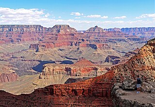
Dunn Butte, is a 5,714 foot-elevation-summit, a minor butte, along a line of three summits along the west drainage of Ninetyone Mile Canyon and Creek. From higher elevation-to-lower, they are Angels Gate, Dunn Butte, and Hawkins Butte. The bases of all three landforms are connected, and Dunn Butte is a south-southwest ridgeline, with the high point prominence at the northeast terminus.
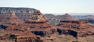
Rama Shrine is a 6,406-foot (1,953 m)-elevation platform-summit located in the eastern Grand Canyon, in Coconino County of northern Arizona, United States. The Shrine is named for Rama, the Hindu god of chivalry and virtue. The landform is attached at the southeast to the Vishnu Temple massif, about 1.0 mile (1.6 km) distant. Rama Shrine is about 3.0 miles (4.8 km) southeast of the Cape Royal overlook, Walhalla Plateau. A twin landform occupies the southwest of Vishnu Temple, the Krishna Shrine. Rama Shrine towers about 4,000 feet (1,200 m) above the Colorado River, about 2.0 miles (3.2 km) southeast. Drainages to the Colorado are east and southeast; between the two Shrines, is the south Asbestos Canyon drainage.
The Rama Shrine prominence is a rectangular platform of the Supai Group, the cliff-former, hard Esplanade Sandstone. Remainder debris of very-shallow slopes of burnt-red Hermit Shale cover the horizontal platform.

Krishna Shrine is a 6,131-foot-elevation summit located in the eastern Grand Canyon, in Coconino County of northern Arizona, US. The landform is attached at the southwest to the Vishnu Temple massif, about 1.0 mi distant. Krishna Shrine is about 3.0 mi south of the Cape Royal overlook, Walhalla Plateau. A twin landform occupies the southeast of Vishnu Temple, the Rama Shrine. Krishna Shrine towers about 4,000 ft above the Colorado River, about 2.0 miles south. Both Shrines, east and west, and Vishnu Temple, center, are at the headwater drainage of Asbestos Canyon. At the southwest of Krishna, on an extending arm of Redwall Limestone is a short unnamed drainage;. The west flank of Krishna Shrine drains into the long southwest-trending Vishnu Canyon and Creek, which comes from Freya Castle and the Walhalla Plateau, South Rim.

The Battleship is a 5,850-foot (1,780 m)-elevation summit located in central Grand Canyon, in Coconino County of northern Arizona, United States. The ridgeline, Battleship landform forms part of the western border of Garden Creek Canyon, which contains the Bright Angel Trail down to the Colorado River, and across it to Phantom Ranch. The east border of Garden Creek Canyon is the South Rim, with the overlooks of Grandeur Point and Yavapai Point. The Battleship is 1.5 miles (2.4 km) northwest of Yavapai Point, 1.5 miles due-north of Grand Canyon Village, and roughly 2.0 miles (3.2 km) southwest of the Colorado River.

Mather Point is a 7,119 foot (2,170 m)-cliff-elevation Point located in the central Grand Canyon, Coconino County of northern Arizona, United States. It was named in honor of Stephen Tyng Mather, an American industrialist and conservationist.

Cocopa Point is a 6,627 foot (2,020 m)-cliff-elevation Point located in the central,, Grand Canyon, Coconino County of northern Arizona, United States. Cocopa Point is 1.1 miles from its closest highest scenic viewpoint, Yuma Point (6,654 ft), located east at Eremita Mesa, at the northeast, overlooking Central Hermit Canyon.
Cocopa Point is in a region of points, at the headwaters of canyons, and landforms below the South Rim. Mimbreno Point lies ~1.7 miles west, and Hermit Canyon and Pima Point, at the west-terminus of West Rim Drive, are about 1.5 mi and 2.0 miles due-east. Cocopa Point is at the northwest of Eremita Mesa; Yuma Point is at the northeast; the mesa lies between Hermit Canyon, east, and Upper Boucher Canyon, west. Cocopa Point is a sheer-walled cliff, sitting at the northwest headwaters of short, Travertine Canyon. At the west of Lower Travertine Canyon, adjacent the Colorado River, sits Whites Butte, about 1.2 miles distant from Cocopa Point.


