Carlton Bank

Last updated

Carlton Bank
Carlton Bank view.jpg
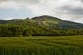
Carlton Bank as seen from the north
Highest point
Elevation 408 m (1,339 ft)
Listing (none)
Coordinates 54°24′57.84″N1°12′4.53″W / 54.4160667°N 1.2012583°W / 54.4160667; -1.2012583
Geography
Location North York Moors, England
Parent range Cleveland Hills
OS grid NZ519026 [1]
Topo map OS Explorer OL26

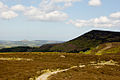
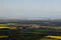
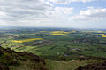
Carlton Bank is a hill in the Cleveland Hills, in north-east England. It is within Carlton Moor in the North York Moors and overlooks the villages of Carlton-in-Cleveland and Faceby. [2] The summit provides extensive views of Teesside including Middlesbrough and Redcar to the north as well as the surrounding moorland. Roseberry Topping can also be clearly seen from the summit in a north-easterly direction. [3] The bank was host to an alum works in the 18th century. [4]

The Cleveland Way National Trail crosses Carlton Bank and is part of Wainwright's Coast to Coast Walk. [5]

A gliding club aerodrome was once situated approximately 500 metres (1,640 ft) south of the summit. [6]

The rock band Mott the Hoople were photographed in the woods for the cover of their third album Wildlife in January 1971.

File:MottWildlife.jpg

Related Research Articles

<span class="mw-page-title-main">North Yorkshire</span> County of England

North Yorkshire is a ceremonial county in the Yorkshire and the Humber and North East regions of England. It borders County Durham to the north, the North Sea to the east, the East Riding of Yorkshire to the south-east, South Yorkshire to the south, West Yorkshire to the south-west, and Cumbria and Lancashire to the west. Northallerton is the county town.

<span class="mw-page-title-main">Guisborough</span> Market town in North Yorkshire, England

Guisborough is a market town and civil parish in the borough of Redcar and Cleveland, North Yorkshire, England. It lies north of the North York Moors National Park. Roseberry Topping, midway between the town and Great Ayton, is a landmark in the national park. At the 2011 census, the civil parish with outlying Upleatham, Dunsdale and Newton under Roseberry had a population of 17,777, of which 16,979 were in the town's built-up area. It was governed by an urban district and rural district in the North Riding of Yorkshire.

<span class="mw-page-title-main">Eston</span> Area of Redcar and Cleveland, North Yorkshire, England

Eston is an area of Redcar and Cleveland in North Yorkshire, England. The local authority ward covering the area had a population of 7,005 at the 2011 census. It is part of Greater Eston, which includes the outlying settlements of Grangetown, Normanby, South Bank, Teesville and part of Ormesby.

<span class="mw-page-title-main">Middlesbrough</span> Town in North Yorkshire, England

Middlesbrough is a town in the Middlesbrough unitary authority borough of North Yorkshire, England. The town lies near the mouth of the River Tees and north of the North York Moors National Park. The built-up area had a population of 148,215 at the 2021 UK census. It is the largest town of the wider urban Tees Valley area, which had a population of 678,400 in 2021.

<span class="mw-page-title-main">Coast to Coast Walk</span> Walk from the west coast to the east coast of Britain

The Coast to Coast Walk is a long-distance footpath between the west and east coasts of Northern England, nominally 190-mile (306 km) long. Devised by Alfred Wainwright, it passes through three contrasting national parks: the Lake District National Park, the Yorkshire Dales National Park, and the North York Moors National Park. The current actual measured distance is reported as 182-mile (293 km).

<span class="mw-page-title-main">Roseberry Topping</span> Prominent hill and landmark in North Yorkshire, England

Roseberry Topping is a distinctive hill in North Yorkshire, England. It is situated near Great Ayton and Newton under Roseberry. Its summit has a distinctive half-cone shape with a jagged cliff, which has led to many comparisons with the much higher Matterhorn in the Swiss-Italian Alps. It forms a symbolic image of the area and features in the logo for the nearby Teesside International Airport.

<span class="mw-page-title-main">Normanby, Redcar and Cleveland</span> Area of Redcar and Cleveland, North Yorkshire, England

Normanby is an area in the borough of Redcar and Cleveland, North Yorkshire, England. A ward covering the area had a population of 6,930 at the 2011 census. It is part of Greater Eston, which includes the area and the outlying settlements of Eston, Grangetown, South Bank, Teesville and part of Ormesby.

<span class="mw-page-title-main">Cringle Moor</span> Hill in Yorkshire, England

Cringle Moor, at 432 m (1,417 ft), is the third-highest hill in the North York Moors, England, and the highest point west of Clay Bank.

<span class="mw-page-title-main">Castleton, North Yorkshire</span> Village in North Yorkshire, England

Castleton is a village on the River Esk, part of the civil parish of Danby in the county of North Yorkshire in England. It can be found 7.1 miles (11.5 km) south-east of Guisborough, in the North York Moors. There was once a medieval castle sited on Castle Hill that is thought to have been abandoned when Danby Castle was constructed.

<span class="mw-page-title-main">Carlton in Cleveland</span> Village in North Yorkshire, England

Carlton in Cleveland is a village in the district of North Yorkshire, England, and on the edge of the North York Moors National Park. It is situated approximately 9 miles (14 km) south of Middlesbrough. The village is commonly known as Carlton, and is the only village in the civil parish of Carlton.

<span class="mw-page-title-main">Newton under Roseberry</span> Village in North Yorkshire, England

Newton under Roseberry is a village in the borough of Redcar and Cleveland and the ceremonial county of North Yorkshire, England. It is on the A173, between Great Ayton and Guisborough and is close to the base of Roseberry Topping.

<span class="mw-page-title-main">Cleveland Hills</span>

The Cleveland Hills are a range of hills on the north-west edge of the North York Moors in North Yorkshire, England, overlooking Cleveland and Teesside. They lie entirely within the boundaries of the North York Moors National Park. Part of the 110-mile (177 km) long Cleveland Way National Trail runs along the hills, and they are also crossed by a section of Wainwright's Coast to Coast Walk. The hills, which rise abruptly from the flat Tees Valley to the north, include distinctive landmarks such as the cone-shaped peak of Roseberry Topping, near the village of Great Ayton – childhood home of Captain James Cook.

<span class="mw-page-title-main">Cleveland Way</span> Long-distance footpath in England

The Cleveland Way is a National Trail in the historic area of Cleveland in North Yorkshire, Northern England. It runs 110 miles (177 km) between Helmsley and the Brigg at Filey, skirting the North York Moors National Park.

<span class="mw-page-title-main">White Rose Walk</span> Footpath in North Yorkshire, England

The White Rose Walk, a 35-mile (56 km) trail located in North Yorkshire, England, was devised in 1968 by the Yorkshire Wayfarers, It starts at the Kilburn White Horse and is completed by touching the trig point on top of Roseberry Topping. The walk whilst recognised by the Long Distance Walkers Association (LDWA) as a long distance walk in itself, mixes and crosses with several other long distance paths including the Cleveland Way, the Coast to Coast Walk, and the Lyke Wake Walk. The route takes in the highest peaks in the area such as Live Moor, Carlton Moor, Sutton Bank, Cold Moor, the Wainstones and Urra Moor. The walk also passes Captain Cooks Monument on Easby Moor.

<span class="mw-page-title-main">Eston Nab</span> Rocky outcrop in North Yorkshire, England

Eston Nab is a rocky outcrop hill in the town of Eston, Redcar and Cleveland, North Yorkshire, England.

<span class="mw-page-title-main">Hasty Bank</span>

Hasty Bank is a hill in the Cleveland Hills range of the North York Moors, in north-east England. The Cleveland Way National Trail crosses Hasty Bank and is part of Wainwright's Coast to Coast Walk. The north face of Hasty Bank has heavily eroded, possessing a vertical rocky face sloping steeply down to Broughton Bank. Roseberry Topping can be clearly seen from the summit which offers great views of the Tees Valley.

Cleveland Mountain Rescue Team is one of five search and rescue teams based in the North East region of England. The team is based in the village of Great Ayton in North Yorkshire. They were called out to 61 incidents in 2019, and 58 in 2020.

<span class="mw-page-title-main">Roseberry Mine</span> A former ironstone mine in Great Ayton, North Yorkshire, England

Roseberry Mine was an ironstone mine in the North Riding of Yorkshire, England, which operated between 1883 and 1924, with a break of 24 years. Both periods of mining used a form of tramway to transport the ironstone out, which connected with the railway line north of Great Ayton railway station. The mine was located on the south side of Roseberry Topping digging into the hillside. Of the three ironstone mines in the Great Ayton area, Roseberry was the largest.

<span class="mw-page-title-main">Ironstone mining in Cleveland and North Yorkshire</span> Ironstone mines and quarries in Cleveland and North Yorkshire, England

Ironstone mining in Cleveland and North Yorkshire occurred on a sizeable scale from the 1830s to the 1960s in present day eastern parts of North Yorkshire but has been recorded as far back as Roman times in mostly a small-scale and intended for local use. This Cleveland is not to be confused with a smaller area covered by the county of Cleveland from 1974-96.

<span class="mw-page-title-main">Slapewath</span> Hamlet in Redcar and Cleveland, England

Slapewath is a hamlet in the borough of Redcar and Cleveland and the ceremonial county of North Yorkshire, England. Whilst the name of the hamlet is recorded as far back as the 13th century, it was developed due to the alum and ironstone industries of the North-Eastern part of Yorkshire in the 16th and 19th centuries respectively. The hamlet lies on the A171 road.

References

  1. The Ordnance Survey gazetteer of Great Britain : all names from the 1:50, 000 landranger map series (3 ed.). London: Macmillan. 1992. p. 135. ISBN   0-333-57897-X.
  2. "Genuki: CARLTON IN CLEVELAND: Geographical and Historical information from the year 1890., Yorkshire (North Riding)". www.genuki.org.uk. Retrieved 28 April 2023.
  3. "Restaurant review: Lord Stones Country Park, Carlton Bank, Chop Gate, North Yorkshire". Yorkshire Post. 22 December 2013. Retrieved 28 April 2023.
  4. Chrystal, Paul (2017). The Place Names of Yorkshire; Cities, Towns, Villages, Rivers and Dales, some Pubs too, in Praise of Yorkshire Ales (1 ed.). Catrine: Stenlake. p. 22. ISBN   9781840337532.
  5. Smith, Jonathan (12 February 2023). "COUNTRY WALK: Taste of the North York Moors on one-way walk". Craven Herald. Retrieved 28 April 2023.
  6. Swabey, David (11 May 2012). "Ramble has fine views and lots of local history". Darlington and Stockton Times. Retrieved 28 April 2023.