Burleigh Head is a small national park at Burleigh Heads in the City of Gold Coast in South East Queensland, Australia.

The North York Moors is an upland area in north-eastern Yorkshire, England. It contains one of the largest expanses of heather moorland in the United Kingdom. The area was designated as a National Park in 1952, through the National Parks and Access to the Countryside Act 1949. Covering an area of 554 sq mi (1,430 km2), the National Park has a population of 23,380. It is administered by the North York Moors National Park Authority, which is based in Helmsley.

The Teton Range is a mountain range of the Rocky Mountains in North America. It extends for approximately 40 miles (64 km) in a north–south direction through the U.S. state of Wyoming, east of the Idaho state line. It is south of Yellowstone National Park, and most of the east side of the range is within Grand Teton National Park.

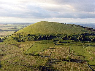
Roseberry Topping is a distinctive hill in North Yorkshire, England. It is situated near Great Ayton and Newton under Roseberry. Its summit has a distinctive half-cone shape with a jagged cliff, which has led to many comparisons with the much higher Matterhorn in the Swiss-Italian Alps. It forms a symbolic image of the area and features in the logo for the nearby Teesside International Airport.

Cross Fell is the highest mountain in the Pennines of Northern England and the highest point in England outside the Lake District. It is located in the North Pennines Area of Outstanding Natural Beauty. It lies within the county of Cumbria and the historic county boundaries of Cumberland.

Robinson is a fell in the English Lake District, its southern slopes descending to Buttermere, while its northern side is set in the Newlands Valley. Paths lead to the summit from the village of Buttermere, from the nearby summit Dale Head and from various locations in the valleys to the north.

Clough Head is a fell, or hill, in the English Lake District. It marks the northern end of the main ridge of the Helvellyn range and is often walked as part of the ridge walk. The fell stands south of the village of Threlkeld and the A66 road, and it forms the steep eastern side of the tranquil valley of St John's in the Vale.

Pike of Stickle, also known as Pike o’ Stickle, is a fell in the English Lake District. It reaches a height of 709 metres (2,326 ft) and is situated in the central part of the national park in the valley of Great Langdale. The fell is one of three fells which make up the picturesque Langdale Pikes, one of the best-known areas in Lakeland. A "stickle" is a hill with a steep prominent rocky top, while a "pike" is a hill with a peaked summit, the name being therefore partly tautological.
Great Mell Fell is an isolated hill or fell in the English Lake District, north of Ullswater and adjacent to the Eastern Fells. It rises from a level plain to a height of 537 m. Its top is a viewpoint for many of the surrounding higher fells. The fell is now owned and managed by the National Trust and offers a place of quiet refuge.

Stickle Pike is an outlying fell located in the southern Lake District near the small town of Broughton-in-Furness, with the summit situated between the lower Duddon Valley and the quiet smaller valley of Dunnerdale. Despite its low altitude the sharp, conical summit is prominent in views from the Broughton and high Furness areas. As with many of the Dunnerdale and Coniston fells, there are reminders of the area's former mining past in the form of many spoil heaps, disused levels and shafts. The fell is also notable for its wide-ranging views despite its low altitude, especially to the Scafells to the north and the sands of the Duddon Estuary to the south. A "stickle" is a hill with a prominent rocky top.

The Cleveland Hills are a range of hills on the north-west edge of the North York Moors in North Yorkshire, England, overlooking Cleveland and Teesside. They lie entirely within the boundaries of the North York Moors National Park. Part of the 110-mile (177 km) long Cleveland Way National Trail runs along the hills, and they are also crossed by a section of Wainwright's Coast to Coast Walk. The hills, which rise abruptly from the flat Tees Valley to the north, include distinctive landmarks such as the cone-shaped peak of Roseberry Topping, near the village of Great Ayton – childhood home of Captain James Cook.

The Cleveland Way is a National Trail in the historic area of Cleveland in North Yorkshire, Northern England. It runs 110 miles (177 km) between Helmsley and the Brigg at Filey, skirting the North York Moors National Park.
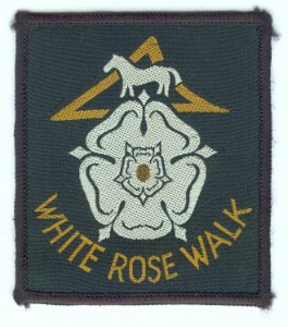
The White Rose Walk, a 35-mile (56 km) trail located in North Yorkshire, England, was devised in 1968 by the Yorkshire Wayfarers, It starts at the Kilburn White Horse and is completed by touching the trig point on top of Roseberry Topping. The walk whilst recognised by the Long Distance Walkers Association (LDWA) as a long distance walk in itself, mixes and crosses with several other long distance paths including the Cleveland Way, the Coast to Coast Walk, and the Lyke Wake Walk. The route takes in the highest peaks in the area such as Live Moor, Carlton Moor, Sutton Bank, Cold Moor, the Wainstones and Urra Moor. The walk also passes Captain Cooks Monument on Easby Moor.
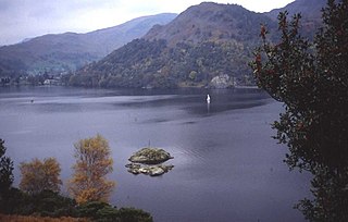
Glenridding Dodd is a small fell in the English Lake District, at the end of a ridge descending from the Helvellyn range in the Eastern Fells. It stands above the village of Glenridding and on the western shore of Ullswater. Although small and not of great elevation, its top is a fine viewpoint for Ullswater and for the fells clustered round the valleys above Patterdale.

Ben Tee is a Scottish mountain situated in the Lochaber area of the Highland council area, some 15 kilometres north of Spean Bridge. It is rated as one of the best of Scotland's smaller mountains with Hamish Brown saying:
Ben Tee is such a shapely cone that it is instantly recognisable from anywhere around the Great Glen or along the Garry. Its isolated situation makes it one of Scotland’s finest summit viewpoints.

Eston Nab is a rocky outcrop hill in the town of Eston, Redcar and Cleveland, North Yorkshire, England.

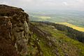
Carlton Bank is a hill in the Cleveland Hills, in north-east England. It is within Carlton Moor in the North York Moors and overlooks the villages of Carlton-in-Cleveland and Faceby. The summit provides extensive views of Teesside including Middlesbrough and Redcar to the north as well as the surrounding moorland. Roseberry Topping can also be clearly seen from the summit in a north-easterly direction. The bank was host to an alum works in the 18th century.

Roseberry Mine was an ironstone mine in the North Riding of Yorkshire, England, which operated between 1883 and 1924, with a break of 24 years. Both periods of mining used a form of tramway to transport the ironstone out, which connected with the railway line north of Great Ayton railway station. The mine was located on the south side of Roseberry Topping digging into the hillside. Of the three ironstone mines in the Great Ayton area, Roseberry was the largest.
The geology of the North York Moors National Park in northern England is provided largely by a thick southerly dipping sequence of sedimentary rocks deposited in the Cleveland Basin during the Jurassic Period. A series of ice ages during the Quaternary period has left a variety of glacial deposits, particularly around the margins of the National Park.

Freebrough Hill is a small peak south of the village of Moorsholm, in Redcar and Cleveland, England. The hill sits just south of the A171 road and when viewed against the landscape, it has a conical-shape effect akin to Roseberry Topping. Suggestions have been put forward the the hill is man-made, but geologists state that it is a natural hill despite its appearance.