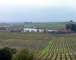
Wine Country is the region of California, in the northern Bay Area, known worldwide as a premium wine-growing region. The region is famed for its wineries, its cuisine,, Michelin star restaurants, boutique hotels, luxury resorts, historic architecture, and culture. Viticulture and wine-making have been practiced in the region since the Spanish missionaries from Mission San Francisco Solano established the first vineyards in 1812.

State Route 121 is a California state highway in the Wine Country that runs northerly from its junction with State Route 37 at Sears Point, past the Tolay Lake basin and across Tolay Creek near Infineon Raceway, veers east at a junction with State Route 116 and Bonneau Road at Schellville, runs eastward through the Carneros region of the southern Sonoma Valley and Napa Valley, then northeastward to end near Lake Berryessa in Napa County.

Oakville is a census-designated place (CDP) in the Napa Valley of Napa County, northern California.

Yountville Domaine Chandon is a winery located in Napa Valley in the town of Yountville, California. Established in 1973 by Moët et Chandon, by businessman John Wright and was the first French-owned sparkling wine producer in Napa Valley.

Ceja Vineyards is a family-owned winery in Napa founded by Mexican-American immigrants. The Ceja family have been growers in the Napa and Sonoma valleys in California for three generations. The wine production company was founded in 1999 and focuses on premium wines. The principals are; Amelia Moran Ceja, President; Martha Ceja, Vice President; Pedro Ceja, Secretary; and Armando Ceja, Treasurer. As of 2008 production is around 10,000 cases per year.

Los Carneros AVA is an American Viticultural Area which includes parts of both Sonoma and Napa counties in California, U.S.A.. It is located north of San Pablo Bay. The proximity to the cool fog and breezes from the bay makes the climate in Los Carneros cooler and more moderate than the wine regions further north in Napa Valley and Sonoma Valley. The cooler climate has made Los Carneros attractive for the cultivation of cooler climate varietals like Pinot noir and Chardonnay. Many of the grapes grown in Los Carneros are used for sparkling wine production. Receiving its AVA status in 1983, the Carneros area was the first wine region in California to be defined by its climate characteristics rather than political boundaries.

Stanley is an unincorporated community in Napa County, California. It lies at an elevation of 20 feet. Stanley is located on the Southern Pacific Railroad, 4.5 miles (7.2 km) north-northwest of Napa Junction.
Rancho Huichica was a 18,704-acre (75.69 km2) Mexican land grant in present day Napa County, California given in 1841 to Jacob P. Leese. Carneros Creek forms the northeast boundary of Rancho Huichica, and the grant contains the majority of the Carneros region in Napa Valley.
Rancho Entre Napa was a 7,000-acre (28 km2) Mexican land grant in present-day Napa County, California given in 1836 by Governor Mariano Chico to Nicholas Higuera. The grant extended along the west bank of the Napa River from present-day Napa south to Carneros Creek.

Collins was an unincorporated community in Napa County, California. It lies at an elevation of 49 feet. Collins is located on the Southern Pacific Railroad, 1.5 miles (2.4 km) south of Napa Junction. In 1992, the community was annexed and incorporated into American Canyon.

Cuttings Wharf is an unincorporated community in Napa County, California. It lies at an elevation of 7 feet. Cuttings Wharf is located on the Napa River, 4 miles (6.4 km) northwest of Napa Junction.

Imola is an unincorporated community in Napa County, California. It lies at an elevation of 7 feet. Imola is located on the Southern Pacific Railroad, 1.25 miles (2.0 km) south of Napa.

Shipyard Acres was an unincorporated community in Napa County, California. It lies at an elevation of 33 feet. Shipyard Acres is located 2.5 miles (4.0 km) south-southeast of Napa. This was a wartime neighborhood consisting of nearly 400 of plywood houses built to house worker families involved in the World War II effort building ships at Basalt Rock Company. It sprang up early in the war and was dismantled sometime in the mid-1950s. It was on the northwest corner of what is now Kaiser Road and Napa-Vallejo Highway. Some of the structures were moved a few miles west to the Cuttings Wharf area, resurrected, and are still in place near the marina.

Union was an unincorporated community in Napa County, California. It lay at an elevation of 79 feet. Union was located on the Southern Pacific Railroad, 2.25 miles (3.6 km) northwest of Napa.
Carneros Creek may refer to:

Carneros Creek is a south by southeastward flowing stream originating in the southernmost Mayacamas Mountains, in Napa County, California. It is the southernmost tributary to the Napa River, entering 2.5 miles (4.0 km) north of San Pablo Bay and 5 miles (8.0 km) south of the town of Napa.
Nicole Abiouness is an American female entrepreneur and winemaker. She owns and operates Abiouness Wines, in Mendocino County, Napa Valley, California where she makes Pinot Noir and Sangiovese wine.

Cakebread Cellars is a Napa Valley winery known for its Chardonnay and Sauvignon Blanc wines, which are internationally distributed. Founded in 1973 by Jack and Dolores Cakebread in Rutherford, California, the winery produces approximately 75,000 cases of wine per year.
Rene di Rosa was an American vintner and art collector.


